The only constant is change, and today we’re proud to announce further progress in our ongoing effort to build a map that can reflect the changes that occur in the real world. Just as we’ve started using map data from a wide range of authoritative sources in the US, Canada, and a number of other countries, we have now updated the base map data for France, Monaco and Luxembourg.
You'll notice improvements in all of our Google Maps products and services for those three countries, such as more comprehensive maps of cities and hillsides. Integrating specialized map data from highly respected organizations like the Institut Geographique National will help both locals and visitors more quickly and easily navigate these unique places.
What’s more, starting today you can share your direct feedback about the maps for France, Monaco and Luxembourg. When you’re zoomed in to any of these regions, you’ll now see the "Report a Problem" tool in the lower right corner of the map. So if you want to tell us about any updates you think need to be made - like a street becoming one-way, or a new housing development in your area - let us know and we’ll do our best to update the map quickly, often within just a few days.
Posted by Ashesh Bakshi, Software Engineer
Tuesday, May 31, 2011
Updated Help Center for Google Map Maker
As part of our ongoing effort to answer your questions about Google Map Maker, we’re introducing a newly designed Help Center. In the new Help Center, you can find clearly documented policies and information about how to make edits and review others’ edits.
This Help Center, available in 20 languages thus far, includes tips and tricks to help ensure that your edits get approved quickly. Where possible, we also provide a rationale for why you’re asked to fill certain attributes or make edits in a particular way.
In addition, we’ve organized the Help Center into five guides, each addressing a key aspect of Map Maker:
- Getting Started - Become familiar with the basic usage and functionality of Map Maker.
- Points: businesses, landmarks, and more - Learn how to add and edit places marked as points on Map Maker.
- Lines: roads, trails, railways, and more - Learn about adding and editing roads, trails and other line features.
- Shapes: buildings and boundaries - Discover how you can map locations such as your campus, buildings and other places as shapes.
- Reviewing options - Find out how you can become a Reviewer and keep track of the changes happening in and around your region.
Please let us know if you have feedback about the new Help Center on the Map Your World forum, as that will help form our next round of improvements. Your tips and best practices for Map Maker are also most welcome.
You can get to the new help center via the Help link at the top right corner of Map Maker or visit http://www.google.com/support/mapmaker.
Friday, May 27, 2011
Google Map Maker Visits Chicago
(Cross-posted from the Google Student Blog)
The Google Map Maker campus tour recently visited the Windy City to talk to students about how they can use Map Maker to map their campuses and make updates to places they care about on Google Maps. While in town, we also hosted a Map Maker event at the Google Chicago office to share the tool with folks working in the public sector. We had a great time meeting so many enthusiastic mappers from the area, and look forward to seeing how they put Chicago on the map.
Our first stop was the University of Chicago campus, a beautifully historic area with architectural gems galore. Students who attended this event were excited to map not only their campus, but neighborhoods near the university, showing the diversity and development of the population and culture.
Our second stop was Northwestern University, where a packed room of students learned about mapping while sampling some traditional Chicago style deep dish pizza. Delicious! Students were particularly interested in adding details to their campus, naming the buildings, adding locations of the sororities and fraternities, and marking the building outlines or footprints of their favorite restaurants and stores nearby.

Our Google Map Maker team loved partnering with Google Student Ambassadors from these campuses, who creatively and passionately helped plan these events. You guys did an amazing job! The Google Student Ambassadors from Northwestern University had this to say about the Map Maker visit:
“Our event brought together over 120 Northwestern students who were eager and excited to learn about how they could make an impact by adding to Google Maps using Map Maker … Map Maker was a welcome product that put the power to shape the map in our hands. All in all, it was an incredibly fun and engaging experience!”
-Sourya and Minjae, Google Student Ambassadors at Northwestern University
The last event—a meeting with public sector officials at the Google office in Chicago—gave us some great insights about how Map Maker can be used for large metropolitan areas. University educators, Department of Transportation employees, Census Bureau representatives, Chicago Health Department folks, and many more shared how they would like to see Map Maker applied to what they do. We really appreciate all their feedback and suggestions, as well as their enthusiasm for how this tool can help them share their work with each other and the public.
Chicago and the surrounding areas were such enjoyable places to visit, full of vibrant and passionate people. We look forward to visiting other campuses in the fall, but don’t wait until then to leave your mark on your campus!
Wednesday, May 25, 2011
Congratulations to Tine Valencic, the 2011 National Geographic Bee Champion
After preparing for months and working their way through a field of several million participating students, the top 10 geographic student masters, met in Washington D.C. today at National Geographic headquarters to compete in the National Geographic Bee. After 124 questions (including the championship round), Tine Valencic from Texas answered this one correctly to take the championship crown:
Question: Thousands of mountain climbers and trekkers rely on Sherpas to aid their ascent of Mount Everest. The southern part of Mount Everest is located in which Nepalese national park?
Answer: Sagarmatha National Park
Google is proud to support National Geographic Bee, for the 3rd year in a row. National Geographic and Google share the same passion for inspiring and encouraging our future generation of leaders and innovators to learn about and explore the world around them. Being geographically literate and understanding the world is a vital skill for students of all ages. Technology, like Google Earth, has helped make the world a more accessible place and students need geographic skills to be prepared for a global future.

The first-place winner, Tine Valencic, won a $25,000 college scholarship, a lifetime membership in the National Geographic Society, and a trip to the Galápagos Islands. The second-place winner and recipient of a $15,000 college scholarship was Georgia's Nilai Sarda and third place and a $10,000 college scholarship went to Kansas' Stefan Petrović. The seven other finalists, who won $500, were Andrew Hull, of Alaska: Luke Hellum, of Arizona; Tuvya Bergson-Michelson, of California; Kevin Mi, of Indiana; Karthik Karnik, of Massachusetts; Alex Kimn, of South Dakota; and Anthony Cheng, of Utah.

Congratulations to Tine Valencic and to all of the students who participated in this year’s National Geographic Bee. We look forward to following all of you as you continue to explore the world and we expect to see some of you at Google after you have earned your degrees.
Check-ins and rating places get easier with Google Maps 5.5 for Android
(Cross posted from Google Mobile Blog)
We’ve made it easier to check in and out of places, rate various locations, and get transit information with Google Maps 5.5 for Android. This release adds ‘check in’ and ‘rate and review’ buttons to Place pages, the option to edit your home/work address for Latitude, and redesigned transit station pages.
Read below for more details about the new features, which we hope will improve your user experience, a topic we take very seriously as there are now more than 200 million users of Google Maps for mobile across platforms and devices worldwide.
New check-in and rating buttons added to Place pages
Now when you open a Place page from your mobile device, you can check in to places with Google Latitude or submit a rating or review by clicking on two new buttons at the top of the listing.
This past week I had the chance to explore the Computer History Museum during my visit to San Francisco from across the pond in London. Once nearby, I could quickly open the museum’s Place page and check in.
 When I was ready to leave and head to lunch, in a few seconds I could go back to the Place page and rate the museum – which certainly earned the 5 star rating it received from me.
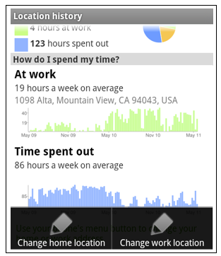
Update home and work address for your Latitude Location History
Last month we released the Location History dashboard for Latitude which estimates how much time you spend at home, work, and everywhere else. If your home or work address changes, or you’d rather set a different address to represent ‘home’ and ‘work,’ you can now edit these addresses within Latitude.
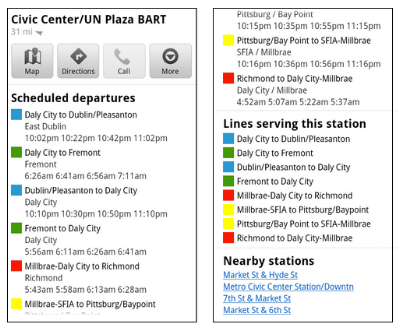
View the redesigned transit station pages
It’s been about two years since we added transit directions in Google Maps for Android. Since then, we’ve increased the coverage from 250 cities to more than 440 and counting - the most recent being Washington, D.C. To make it easier to plan your transit route, we updated the transit station pages in this release to better organize the information you need.
Each page now includes a list of upcoming scheduled departures for different lines, all the transit lines serving the station, and links to nearby transit stations.
Download Google Maps 5.5 for Android here to try out the new check-in and rating buttons, update your Latitude Location History home/work address, check out a transit station in a nearby city, or just make sure you have the latest version of Google Maps for Android. This update requires an Android OS 1.6+ device anywhere Google Maps is currently available. Learn more in our help center.
We’ve made it easier to check in and out of places, rate various locations, and get transit information with Google Maps 5.5 for Android. This release adds ‘check in’ and ‘rate and review’ buttons to Place pages, the option to edit your home/work address for Latitude, and redesigned transit station pages.
Read below for more details about the new features, which we hope will improve your user experience, a topic we take very seriously as there are now more than 200 million users of Google Maps for mobile across platforms and devices worldwide.
New check-in and rating buttons added to Place pages
Now when you open a Place page from your mobile device, you can check in to places with Google Latitude or submit a rating or review by clicking on two new buttons at the top of the listing.
This past week I had the chance to explore the Computer History Museum during my visit to San Francisco from across the pond in London. Once nearby, I could quickly open the museum’s Place page and check in.
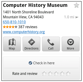 When I was ready to leave and head to lunch, in a few seconds I could go back to the Place page and rate the museum – which certainly earned the 5 star rating it received from me.
Update home and work address for your Latitude Location History
Last month we released the Location History dashboard for Latitude which estimates how much time you spend at home, work, and everywhere else. If your home or work address changes, or you’d rather set a different address to represent ‘home’ and ‘work,’ you can now edit these addresses within Latitude.

Change home/work location from Location History dashboard
View the redesigned transit station pages
It’s been about two years since we added transit directions in Google Maps for Android. Since then, we’ve increased the coverage from 250 cities to more than 440 and counting - the most recent being Washington, D.C. To make it easier to plan your transit route, we updated the transit station pages in this release to better organize the information you need.
Each page now includes a list of upcoming scheduled departures for different lines, all the transit lines serving the station, and links to nearby transit stations.

Download Google Maps 5.5 for Android here to try out the new check-in and rating buttons, update your Latitude Location History home/work address, check out a transit station in a nearby city, or just make sure you have the latest version of Google Maps for Android. This update requires an Android OS 1.6+ device anywhere Google Maps is currently available. Learn more in our help center.
Friday, May 20, 2011
Imagery Update - Week of May 16th
The Google Earth and Google Maps Imagery Team has just published its latest batch of satellite and aerial imagery, and as always, there are all kinds of fascinating sites and features to check out.
It’s mid-May and summer is just around the corner. That means vacation! And since many of us like to head to the water for our leisure time, we’ve compiled examples of a few coastal areas that have received updated imagery in our latest release.
In the States, premiere beach vacation spots include the coral-sand beaches that line Miami, Florida. Below is a stretch of the world-famous South Beach within the City of Miami Beach’s City Center district. This high-resolution aerial image was taken this past March, during Spring Break.

If hot, crowded beaches aren’t your thing, there are many cooler places (literally) you could spend your leisure time exploring. Below is a high-resolution aerial image from this past April of Bear Glacier in the Kenai Fjords National Park, Alaska. In this image, you can see the glacier toe as well as the ice, meltwater, and debris it deposits. This valley outflow glacier is sourced from the Harding Icefield, the largest icefield contained entirely within the United States. If you’re viewing this in Google Earth, be sure to use the Historical Imagery time slider to view how the glacier’s size has changed over time.


As always, these are but a few examples of the types of features that can be seen and discovered in our latest batch of published imagery. Happy exploring!
High Resolution Aerial Updates:
USA: Myrtle Beach, Miami, Palm Beach, Lake City, Lynchburg, Lenoir, Dallas, Grand Rapids, Anchorage, Kenai, Tyonek
Countries/Regions receiving High Resolution Satellite Updates:
Albania, Algeria, Angola, Antarctica, Argentina, Australia, Austria, Azerbaijan, Bahamas, Bangladesh, Belarus, Belize, Benin, Bhutan, Bolivia, Bosnia and Herzegovina, Botswana, Brazil, Bulgaria, Burkina Faso, Canada, Cape Verde, Chad, Chile, China, Colombia, Costa Rica, Croatia, Cuba, Cyprus, Côte d'Ivoire, Democratic Republic of the Congo, Djibouti, Dominican Republic, Ecuador, Egypt, El Salvador, Eritrea, Estonia, Ethiopia, Fiji, Finland, France, French Guiana, Gambia, Germany, Greece, Grenada, Guam, Guatemala, Haiti, Hong Kong, Hungary, Iceland, India, Indonesia, Iran, Ireland, Israel, Italy, Jan Mayen, Japan, Jordan, Kazakhstan, Kenya, Kuwait, Laos, Latvia, Lebanon, Lesotho, Lithuania, Madagascar, Malawi, Malaysia, Mali, Mauritania, Mexico, Moldova, Mongolia, Morocco, Mozambique, Myanmar, Namibia, Nepal, Netherlands, New Caledonia, New Zealand, Niger, Nigeria, North Korea, Norway, Pakistan, Palmyra Atoll, Panama, Papua New Guinea, Paraguay, Peru, Philippines, Poland, Portugal, Qatar, Romania, Russia, Samoa, Saudi Arabia, Senegal, Serbia, Slovakia, Slovenia, Somalia, South Africa, Spain, Sri Lanka, St. Helena, St. Vincent and the Grenadines, Sudan, Suriname, Svalbard, Swaziland, Sweden, Switzerland, Syria, São Tomé and Príncipe, Taiwan, Tanzania, Thailand, Trinidad and Tobago, Tunisia, Turkey, Uganda, Ukraine, United Arab Emirates, United Kingdom, United States, Uruguay, Venezuela, Vietnam, West Bank, Western Sahara, Yemen, Zambia, Zimbabwe
These updates are now available in both Google Maps and Google Earth. To get a complete picture of where we updated imagery, download this KML for viewing in Google Earth.
Google Maps on your mobile browser
(Cross-posted from the Google Mobile Blog)
With 40% of Google Maps usage on mobile devices, we want you to have a consistent Google Maps experience wherever you use it. So, today we’re announcing our updated Google Maps experience for mobile browsers on Android and iOS.
Now, when you visit maps.google.com on your phone or tablet’s browser and opt-in to share your location, you can use many of the same Google Maps features you’re used to from the desktop. This will allow you to: This past weekend, I was at a team off-site at a ropes course and needed to find a good deli spot to grab lunch. I opened Google Maps on my mobile browser and searched to locate a popular deli nearby. A few finger taps later, I had viewed photos and reviews on the deli’s Place page and found the quickest way to get there using driving directions- all from my mobile browser.

Google Maps for mobile browsers is platform independent - you will always get a consistent experience and the latest features without needing to install any updates, no matter what phone you use.
To get started exploring Google Maps in your mobile browser, go to http://maps.google.com or any domain where Google Maps is available. Learn more in our help center.
With 40% of Google Maps usage on mobile devices, we want you to have a consistent Google Maps experience wherever you use it. So, today we’re announcing our updated Google Maps experience for mobile browsers on Android and iOS.
Now, when you visit maps.google.com on your phone or tablet’s browser and opt-in to share your location, you can use many of the same Google Maps features you’re used to from the desktop. This will allow you to:
- See your current location
- Search for what’s nearby with suggest and auto complete
- Have clickable icons of popular businesses and transit stations
- Get driving, transit, biking, and walking directions
- Turn on satellite, transit, traffic, biking, and other layers
- View Place pages with photos, ratings, hours, and more
- When signed into your Google account, access your starred locations and My Maps
 This past weekend, I was at a team off-site at a ropes course and needed to find a good deli spot to grab lunch. I opened Google Maps on my mobile browser and searched to locate a popular deli nearby. A few finger taps later, I had viewed photos and reviews on the deli’s Place page and found the quickest way to get there using driving directions- all from my mobile browser.
To get started exploring Google Maps in your mobile browser, go to http://maps.google.com or any domain where Google Maps is available. Learn more in our help center.
Wednesday, May 18, 2011
Better access to your content is, well, better
(Cross-posted from the Google Places Blog.)
Google Places makes it quick and easy for you to tell your friends, and the world, what you think about the places you visit.
And since your reviews are your reviews, we figured giving you access to all this content in one convenient way might be helpful. Now, when you visit your profile on Google Places (to find it, click on your picture in the upper left of the screen), you’ll find a link along the left that points to an Atom feed of all the place ratings and reviews you’ve created on Google. The feed address is known only to you, but you are free to share it however you want. So, go on, enjoy your data.
In addition to taking your Google Places ratings and reviews with you, we also thought it’d be useful if you could more easily rate and review on Google the places you’ve found elsewhere in your travels or on the web.
To do that, just find the URL of a public GeoRSS/Atom feed that contains place information you care about. This could be anything from a feed of your Foursquare check-ins to a My Map you may have created years ago. Paste the URL into the search box on Google Places. We’ll show you place cards that line up, as best as we’re able to determine, with the places in the public geo feed. Then, you can rate to your heart’s content.
By making it easier for you take your opinions with you and rate familiar places quickly, we hope you’ll find more places you love, no matter where you may have discovered them.
Posted by Juan Silveira, Software Engineer
Mississippi floods: images and data
Emerging as one of the worst flooding events along the U.S. waterway in the past century, the Mississippi River floods of April and May 2011 have caused widespread destruction along the 2,300 mile river system. Historically high water levels from heavy rains and springtime snowmelt have provided no shortage of dramatic scenes -- levees breached, downtown areas completely submerged, spillways opened, and more.
The Google Crisis Response team has assembled a collection of flood data including satellite imagery for impacted cities along the river from GeoEye, flood extent and crest data forecasts from the US Army Corps of Engineers (kml) and NOAA’s National Weather Service (kml), and shelter locations from the American Red Cross (kml).

Opened floodgate in Morganza spillway in Louisiana on May 15, 2011. View full-size.

Cairo, Illinois on May 8, 2011. View full-size.
Monday, May 16, 2011
Exploring space with Google
Cross-posted from the Google Students Blog
Update: The live interview with the crew of the Endeavour will stream at 6 AM Eastern time on Thursday at youtube.com/pbsnewshour. That's 11 AM in London, 12 PM for much of Europe, and 3 AM on the West Coast of the United States. Don't worry, it'll be up soon after for later viewing.
At Google, we’re never afraid to think big, and our mission to organize the world's information and make it universally accessible and useful doesn't stop at our exosphere. The universe is full of information, and as we push the boundaries of exploration, our job will be to organize it and make it searchable.
It shouldn’t come as a surprise to anyone out there that we have a passion for space. Google’s culture of innovation stems from our pioneering quest for knowledge; each one of us is empowered to think differently, break the limits, and take intelligent risks. Googlers are scientists, engineers, technologists, space enthusiasts; I have yet to meet a Googler who didn’t share the spirit of exploration.
In partnership with NASA, and PBS, YouTube and Google Moderator will pose your questions to the crew of STS-134, the final mission of the space Shuttle Endeavour, in a live interview emceed by stellar talent (another space joke!) Miles O'Brien.
To mark the occasion, we put together this video to celebrate our love for space, told with the help of products we pour our hearts into every day. You’ll see everything from historical sky maps featured in Google Earth, to 3D buildings at Kennedy Space Center, and our salute to both the astounding achievement of the Apollo era and the Google Lunar X PRIZE, a new space race of entrepreneurial leadership.
With our main campus less than a mile away from the NASA Ames Research Center, it seemed natural that our organizations should strike up a relationship and find ways to work together. Over the years, we have collaborated with our NASA colleagues on some amazing projects, and are very proud of the joint work and collaboration that have contributed to our space products, such as Moon and Mars in Google Earth. Most importantly, the longstanding friendship between our organizations means we can use our skills to complement each other, and bring people together around the globe. Literally. When we say around the globe, we mean....around the globe. With an altitude of roughly 200 miles, and orbiting at about 17,500 miles per hour! (I crack myself up with my space jokes.)
We hope you love the video as much as we do; it's our way of making space exploration open and accessible to everyone. Happy viewing, and keep exploring!
Google Map Maker on Campus
As part of the recent US Map Maker launch, the Map Maker Community team has begun a series of campus visits across the US.
Our first stop was the University of California at Berkeley, where we gave students and faculty a chance to learn about Google Map Maker and work with Map Maker team members in person to map their campus.

Even though the map of Berkeley and the UC Berkeley Campus on Google Maps were already well mapped, students still identified many opportunities to add their local knowledge to the map. Edits included moving location markers, tracing building boundaries, and adding names of campus dorms. The Google Map Maker community team was on site to guide these new mappers and note their thoughtful feedback.

Participants were excited about making corrections and contributions to the map in their area, particularly the U.C. Berkeley campus, and seeing the edits they made appear on the monitor that had been set up on the big screen at the front of the room to show real-time mapping.
Everyone has local knowledge they can add to the map. Help us make your school look even better! Check out your college campus at mapmaker.google.com and leave your mark on the map by drawing walking paths, adding details to your school's buildings, and more.
For more information on how to get started and to connect with other mappers, check out the Google Map Maker community forum. You can also reach out to the Map Maker community team at mapping@google.com.
Happy Mapping!
Thursday, May 12, 2011
Google Transit goes to Washington
[Cross-posted from the Official Google Blog]
Every day, many thousands of commuters, locals, and tourists ride public transit in Washington, D.C. To help all of these transit riders find their way around the metro area, today we’re making comprehensive information about D.C.’s public transportation available on Google Transit.
In partnership with the Washington Metropolitan Area Transit Authority (WMATA), we’re adding all of D.C.’s Metro and bus stations, stops and routes, as well as connections to other transit systems in nearby cities. You can find this information on Google Maps as well as Google Maps for mobile—no matter where you are, you can get to where you’re going. With Google Transit, D.C. metro-area commuters—including those in Baltimore, Montgomery and Jefferson counties—may discover a quicker route to work, while visitors can easily make their way from Reagan National Airport straight to the Smithsonian.

Public transportation is a vital part of city infrastructure and can help alleviate congestion and reduce emissions. But planning your trip on public transit can be challenging, especially when there are multiple transit agencies and you need to use information from multiple sources to figure out the best route. With mapping tools like the transit feature, we’re working to make that easier.
Directions are also available on Google Maps for mobile—so if you’re graduating from GWU and want to meet some friends in Adams Morgan to celebrate, it’s as easy as pulling out your phone. If you’re using an Android device, for example, search for [Adams Morgan] in Google Maps, click on the Places result and select “Directions.” Switch to Transit in the upper-left corner and find out which bus gets you there fastest.

Wherever your journey takes you, whether using public transit, driving, biking or walking, we hope Google Transit directions in D.C. make finding your way a little easier.
Every day, many thousands of commuters, locals, and tourists ride public transit in Washington, D.C. To help all of these transit riders find their way around the metro area, today we’re making comprehensive information about D.C.’s public transportation available on Google Transit.
In partnership with the Washington Metropolitan Area Transit Authority (WMATA), we’re adding all of D.C.’s Metro and bus stations, stops and routes, as well as connections to other transit systems in nearby cities. You can find this information on Google Maps as well as Google Maps for mobile—no matter where you are, you can get to where you’re going. With Google Transit, D.C. metro-area commuters—including those in Baltimore, Montgomery and Jefferson counties—may discover a quicker route to work, while visitors can easily make their way from Reagan National Airport straight to the Smithsonian.
Public transportation is a vital part of city infrastructure and can help alleviate congestion and reduce emissions. But planning your trip on public transit can be challenging, especially when there are multiple transit agencies and you need to use information from multiple sources to figure out the best route. With mapping tools like the transit feature, we’re working to make that easier.
Directions are also available on Google Maps for mobile—so if you’re graduating from GWU and want to meet some friends in Adams Morgan to celebrate, it’s as easy as pulling out your phone. If you’re using an Android device, for example, search for [Adams Morgan] in Google Maps, click on the Places result and select “Directions.” Switch to Transit in the upper-left corner and find out which bus gets you there fastest.
Wherever your journey takes you, whether using public transit, driving, biking or walking, we hope Google Transit directions in D.C. make finding your way a little easier.
Showcase your business with a 360-degree perspective
When I’m looking for a restaurant in San Francisco, I always browse photos to see if the ambiance is right for the occasion. With our Business Photos pilot, we’ve been photographing businesses, with their permission, to highlight the qualities that make their locations stand out. In addition to the photos that business owners can upload directly through Google Places, these photos help potential customers get a better view of the decor, merchandise, food, and more on each business’ Place page.

Gruhn Guitars Inc. in Nashville, Tennessee, United States
We’ve also been taking 360-degree photography to help businesses owners showcase their locations further, and starting today you can experience that panoramic perspective for select businesses in the United States, Japan, Australia, and New Zealand.
This experience, using Street View technology, includes 360-degree imagery of the business interior and storefront. With this immersive imagery, potential customers can easily imagine themselves at the business and decide if they want to visit in person.

Tenkai, Kyoto, Japan
We’re now starting to make these images available through the Place pages of select businesses we’ve photographed. When 360-degree imagery of a business is available, you’ll see an arrow appear over the thumbnail Street View image on that business’ Place page. Press the arrow to preview the storefront or interior, then click on the thumbnail to see the image in Street View.

Storefront thumbnail for Susan Avery Flowers and Event Styling in Australia
With this pilot, you'll begin to see additional photo experiences on the Place pages of a growing number of businesses. As additional imagery becomes available for more locations in the coming months, you’ll also be able to enter the interior perspective of businesses directly from the Street View images of nearby roads on Google Maps.
We’re continuing this program with businesses in select cities in the United States, Japan, Australia, New Zealand, UK, South Korea, and France. If you would like to highlight your business to Google Maps users, please visit the Business Photos site to learn more and apply.
Posted by Gadi Royz, Product Manager, Google Maps
Wednesday, May 11, 2011
Sign up for the Geo Teachers Institute
This fall, we will host two Google Geo Teachers Institutes: September 23 and 24, 2011 in Washington DC at National Geographic Headquarters and September 26 and 27, 2011 at the University of Southern Maine Lewiston-Auburn College in Lewiston, Maine.
This event is a free professional development experience designed to help educators get the most from Google's geo products and technologies. The Geo Teachers Institute is an intensive, two-day event where participants get hands-on experience using Google Earth, Google Maps, and Google SketchUp, including a focus on features like Ocean, Mars, Moon and Sky in Google Earth.
Attendees will learn about innovative instructional strategies and receive resources to share with colleagues. The Google Geo Education team hopes this event will empower educators to bring the world's geographic information to students in a compelling, fresh, and fun way.
If you are interested, please complete this application. You will be notified if you are selected by August 15, 2011. Even if you can’t make it to this event, we have many online resources available for Google Earth and SketchUp and encourage you to check them out.
Thursday, May 5, 2011
Using the power of mapping to support South Sudan
[Cross-posted from the Official Google Blog]
Last Thursday, the Google Map Maker team, along with the World Bank and UNITAR/UNOSAT, held a unique event at the World Bank Headquarters in Washington, D.C., and a satellite event in Nairobi at the same time. More than 70 members of the Sudanese diaspora, along with regional experts from the World Bank, Sudan Institute, Voices for Sudan, The Enough Project and other organizations gathered together to map what is expected to become the world’s newest country later this year: the Republic of South Sudan. UN Secretary-General Ban Ki-moon has asked the international community “to assist all Sudanese towards greater stability and development” during and beyond this period of transition.
South Sudan is a large but under-mapped region, and there are very few high-quality maps that display essential features like roads, hospitals and schools. Up-to-date maps are particularly important to humanitarian aid groups, as they help responders target their efforts and mobilize their resources of equipment, personnel and supplies. More generally, maps are an important foundation for the development of the infrastructure and economy of the country and region.
The Map Maker community—a wide-ranging group of volunteers that help build more comprehensive maps of the world using our online mapping tool, Google Map Maker—has been contributing to the mapping effort for Sudan since the referendum on January 9. To aid their work, we’ve published updated satellite imagery of the region, covering 125,000 square kilometers and 40 percent of the U.N.’s priority areas, to Google Earth and Maps.
The goal of last week’s event was to engage and train members of the Sudanese diaspora in the United States, and others who have lived and worked in the region, to use Google Map Maker so they could contribute their local knowledge of the region to the ongoing mapping effort, particularly in the area of social infrastructure. Our hope is that this event and others like it will help build a self-sufficient mapping community that will contribute their local expertise and remain engaged in Sudan over time.
We were inspired by the group’s enthusiasm. One attendee told us: “I used to live in this small village that before today did not exist on any maps that I know of...a place unknown to the world. Now I can show to my kids, my friends, my community, where I used to live and better tell the story of my people.”

The group worked together to make several hundred edits to the map of Sudan in four hours. As those edits are approved, they’ll appear live in Google Maps, available for all the world to see. But this wasn’t just a one-day undertaking—attendees will now return to their home communities armed with new tools and ready to teach their friends and family how to join the effort. We look forward to seeing the Southern Sudanese mapping community grow and flourish.
Last Thursday, the Google Map Maker team, along with the World Bank and UNITAR/UNOSAT, held a unique event at the World Bank Headquarters in Washington, D.C., and a satellite event in Nairobi at the same time. More than 70 members of the Sudanese diaspora, along with regional experts from the World Bank, Sudan Institute, Voices for Sudan, The Enough Project and other organizations gathered together to map what is expected to become the world’s newest country later this year: the Republic of South Sudan. UN Secretary-General Ban Ki-moon has asked the international community “to assist all Sudanese towards greater stability and development” during and beyond this period of transition.
South Sudan is a large but under-mapped region, and there are very few high-quality maps that display essential features like roads, hospitals and schools. Up-to-date maps are particularly important to humanitarian aid groups, as they help responders target their efforts and mobilize their resources of equipment, personnel and supplies. More generally, maps are an important foundation for the development of the infrastructure and economy of the country and region.
The Map Maker community—a wide-ranging group of volunteers that help build more comprehensive maps of the world using our online mapping tool, Google Map Maker—has been contributing to the mapping effort for Sudan since the referendum on January 9. To aid their work, we’ve published updated satellite imagery of the region, covering 125,000 square kilometers and 40 percent of the U.N.’s priority areas, to Google Earth and Maps.
We were inspired by the group’s enthusiasm. One attendee told us: “I used to live in this small village that before today did not exist on any maps that I know of...a place unknown to the world. Now I can show to my kids, my friends, my community, where I used to live and better tell the story of my people.”

Google Earth optimized for Android-powered tablets
Cross-posted from the Official Google Blog
When we launched Google Earth in 2005, most of us were still using flip phones. At the time, the thought of being able to cart around 197 million square miles of Earth in your pocket was still a distant dream. Last year, that dream came to fruition for Android users when we released Google Earth for Android. With the recent release of tablets based on Android 3.0, we wanted to take full advantage of the large screens and powerful processors that this exciting new breed of tablets had to offer.
Today’s update to Google Earth for Android makes Earth look better than ever on your tablet. We’ve added support for fully textured 3D buildings, so your tour through the streets of Manhattan will look more realistic than ever. There’s also a new action bar up top, enabling easier access to search, the option to “fly to your location” and layers such as Places, Panoramio photos, Wikipedia and 3D buildings.
Moving from a mobile phone to a tablet was like going from a regular movie theatre to IMAX. We took advantage of the larger screen size, including features like content pop-ups appearing within Earth view, so you can see more information without switching back and forth between pages.
One of my favorite buildings to fly around in Google Earth has always been the Colosseum in Rome, Italy:

With the larger tablet screen, I can fly around the 3D Colosseum while also browsing user photos from Panoramio. The photos pop up within the imagery so I can interact with them without losing sight of the Colosseum and its surroundings. Also, by clicking on the layer button on the action bar, I can choose which layers I want to browse.
This version is available for devices with Android 2.1 and above. The new tablet design is available for devices with Android 3.0 (Honeycomb) and above. Please visit the Google Earth help center for more information.
To download or update Google Earth, head to m.google.com/earth in your device’s browser or visit Android Market. Enjoy a whole new world of Google Earth for tablets!
Tuesday, May 3, 2011
Announcing the Google Earth Outreach Developer Grants Program
(Cross-posted from the Official Google.org Blog)
Over the years, the Google Earth Outreach team has seen hundreds of maps that nonprofits are using to change the world for the better. We’ve also talked to just as many nonprofits who have a great idea for a map they want to create, but don’t have people on their team with enough technical skills to create it.
Today, we’re excited to announce the Google Earth Outreach Developer Grants program, supporting selected projects from eligible nonprofit organizations that are using Google’s mapping technologies in novel, innovative ways to make the world a better place.
Through this program, non-profit organizations from all over the world will have an opportunity to receive up to $20,000 that will help turn their mapping ideas to support their causes into a reality. Numerous nonprofits have already used Google Earth to raise awareness about an issue or cause that demonstrate innovation and creativity. The US Holocaust Memorial Museum and partners created the Crisis in Darfur Google Earth layer, which utilized Google Earth’s high-resolution satellite imagery to document the burning of villages, destruction of communities and livelihoods as a result of the genocide in Sudan. The presentation of refugee stories and testimonials in a map visualization brought 26 times the usual number of visitors to the USHMM’s “How Can I Help?” section of the website.
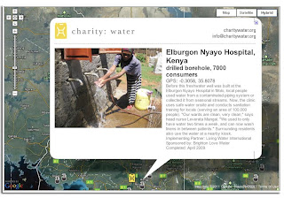
Charity:Water uses the Google Maps API to show donors precisely where the money they contributed was allocated. After donating, donors receive geographic coordinates to view the location of a well to which they’ve contributed, and they can also view pictures of people accessing clean drinking water as a result of their contribution.
Applications to the Google Earth Outreach Developer Grants program will be accepted until May 26, 2011. More details of the program, project requirements and eligibility can be found on the Google Earth Outreach Developer Grants page. Apply today!
Over the years, the Google Earth Outreach team has seen hundreds of maps that nonprofits are using to change the world for the better. We’ve also talked to just as many nonprofits who have a great idea for a map they want to create, but don’t have people on their team with enough technical skills to create it.
Today, we’re excited to announce the Google Earth Outreach Developer Grants program, supporting selected projects from eligible nonprofit organizations that are using Google’s mapping technologies in novel, innovative ways to make the world a better place.
Through this program, non-profit organizations from all over the world will have an opportunity to receive up to $20,000 that will help turn their mapping ideas to support their causes into a reality. Numerous nonprofits have already used Google Earth to raise awareness about an issue or cause that demonstrate innovation and creativity. The US Holocaust Memorial Museum and partners created the Crisis in Darfur Google Earth layer, which utilized Google Earth’s high-resolution satellite imagery to document the burning of villages, destruction of communities and livelihoods as a result of the genocide in Sudan. The presentation of refugee stories and testimonials in a map visualization brought 26 times the usual number of visitors to the USHMM’s “How Can I Help?” section of the website.
Charity:Water uses the Google Maps API to show donors precisely where the money they contributed was allocated. After donating, donors receive geographic coordinates to view the location of a well to which they’ve contributed, and they can also view pictures of people accessing clean drinking water as a result of their contribution.
Charity:Water connects donors to well sites all over the globe.
Applications to the Google Earth Outreach Developer Grants program will be accepted until May 26, 2011. More details of the program, project requirements and eligibility can be found on the Google Earth Outreach Developer Grants page. Apply today!
Imagery Update - Week of May 2nd
Update (May 3, 2011): This imagery update is now live in Google Earth and will be live soon in Google Maps. To see the places around the world that we've updated this time around, please download this KML.
The Google Earth and Google Maps Imagery Team will be publishing the latest batch of imagery in our next update, and as always, there are numerous fascinating and notable areas around the world.
One of the areas that was already slated for this regular update is Abbottabad, Pakistan, which is of particular interest given yesterday’s news. The imagery of this area that is currently available in Google Earth and Maps is from 2005. Higher resolution imagery taken in May 2010 has been prepared for our next imagery update release. However, given the number of inquiries we have received about this area, and to help users better understand recent events, we’ve published an advanced preview KML of the new imagery for viewing in Google Earth. This imagery will be pushed live in Google Earth and Maps as part of our next periodic imagery update.
In addition, as part of our continued effort to provide up-to-date imagery, we’ve worked with our provider again to obtain even fresher satellite imagery of Abbottabad, Pakistan from this morning local time. We have provided this imagery, which is of lower resolution than the scheduled update, to the media. This imagery will be accessible in the near future through the Historical Imagery feature of Google Earth.

This round of imagery also includes many other interesting sites, a few of which are shown below.
Here’s an image of the Harris County Court House of 1910, located in downtown Houston, Texas. Here you can see the ongoing restoration of the building, returning to glory its halls of justice. It is one of the most important historical buildings in Houston, and is often considered one of the best examples of historic courthouses in Texas.

Below is an image of part of Milwaukee, Wisconsin. In it you can see two industries that are part of the might of Milwaukee: the Harley Davidson factory (right hand side of image) and the Miller Brewing Company (left hand side of image).

Now here’s a colorful sight: the Clipsal 500 Adelaide race, a four-day event consisting of two 250 km races of V8 Supercars. The race is often attended by well over a quarter million people. This photo shows the race in March 2010.

These updates will be made available soon in both Google Maps and Google Earth.
High Resolution Aerial Updates:
USA: Brookshire, TX; Brownsville, TX; Dallas, TX; Ft Stockton, TX; Hebbronville, TX; Houston, TX; Laredo, TX; McAllen, TX; Milwaukee, WI; Padre Island, TX; Wharton, TX; Zapata, TX;
Australia: Central Coast, New Castle, and Salamander Bay
Norway: Buskerud, Fredrikstad, and Oslo
Countries/Regions receiving High Resolution Satellite Updates:
Algeria, Angola, Antarctica, Antigua and Barbuda, Argentina, Australia, Austria, Bangladesh, Belarus, Benin, Bolivia, Brazil, Burundi, Cameroon, Canada, Central African Republic, Chad, Chile, China, Colombia, Costa Rica, Croatia, Czech Republic, Democratic People's Republic of Korea, Democratic Republic of the Congo, Denmark, Djibouti, Dominican Republic, Egypt, Eritrea, Estonia, Ethiopia, Finland, France, Georgia, Germany, Greece, Greenland, Grenada, Guadeloupe, Guinea, Haiti, Honduras, Hungary, India, Indonesia, Iran, Ireland, Israel, Italy, Japan, Jordan, Kenya, Kuwait, Latvia, Lebanon, Lesotho, Lithuania, Madagascar, Malawi, Mali, Mexico, Mongolia, Morocco, Mozambique, Myanmar, Namibia, Nepal, Netherlands, New Zealand, Niger, Nigeria, Norway, Oman, Pakistan, Paraguay, Peru, Philippines, Poland, Portugal, Republic of Korea, Romania, Russia, Saudi Arabia, Senegal, Serbia, Seychelles, Sierra Leone, Slovakia, Somalia, South Africa, Spain, Sri Lanka, Svalbard, Swaziland, Sweden, Switzerland, Syria, Taiwan, Tanzania, Thailand, The Gambia, Tunisia, Turkey, Uganda, Ukraine, United Arab Emirates, United Kingdom, United States, Uruguay, Venezuela, West Bank, Western Sahara, Yemen, Zambia, Zimbabwe
Mapping the BolderBOULDER in 3D
The BolderBOULDER is one of the United States’ biggest 10K road races. Last year, more than 54,000 people participated, including several members of the SketchUp team and plenty of other Googlers from the Boulder office—after all, it’s right in our backyard.
Back in January, a group of us met with the race’s organizers to figure out ways that our geo-technology might play a role in this great local tradition. Our team ended up putting together a couple of nifty 3D maps that should help everyone (runners and spectators) get their bearings ahead of race day on May 30th:

The 3D Course Map lets you preview the race route in Google Earth.
We used the Google Earth API to embed an interactive course map on BolderBOULDER’s website. With the Google Earth plug-in installed, you will be able to see hundreds of 3D models of the buildings along the course, as well as special race day structures we modeled just for the event. Be sure to click “Run the Race” (in the upper-left corner of the screen) to take a guided tour of the course.

The Transportation Map provides information about getting to the race.
To help folks get to and from the race, we used the Google Maps API to embed a map with information about public transportation options, road closures and parking.
Whether you’re planning to join us in Boulder or just perusing the course from afar, feel free to explore the maps we built. No running shoes required, and no one’s keeping time.
Posted by Kay Chen, Geo Program Manager
Back in January, a group of us met with the race’s organizers to figure out ways that our geo-technology might play a role in this great local tradition. Our team ended up putting together a couple of nifty 3D maps that should help everyone (runners and spectators) get their bearings ahead of race day on May 30th:

We used the Google Earth API to embed an interactive course map on BolderBOULDER’s website. With the Google Earth plug-in installed, you will be able to see hundreds of 3D models of the buildings along the course, as well as special race day structures we modeled just for the event. Be sure to click “Run the Race” (in the upper-left corner of the screen) to take a guided tour of the course.
To help folks get to and from the race, we used the Google Maps API to embed a map with information about public transportation options, road closures and parking.
Whether you’re planning to join us in Boulder or just perusing the course from afar, feel free to explore the maps we built. No running shoes required, and no one’s keeping time.
Posted by Kay Chen, Geo Program Manager
Traffic information coming to Google Maps in Sweden and Taiwan
When you turn to Google Maps to get from A to B, we want to help you find the quickest way to get there. Knowledge about the current traffic conditions on the roads can help you determine when to set out on your journeys and which routes to take.
With this in mind, we’ve just expanded our coverage of traffic information on Google Maps to include Sweden and Taiwan. Users in both places can now check the latest on road congestion with their desktop browsers or mobile phones. The traffic information covers all major thoroughfares as well as arterial roads in select cities.

Traffic information around Stockholm, Sweden
When accessing Google Maps, the widget in the upper-right allows you to select additional map layers that display more detailed information. To view traffic information, move your mouse over the widget and select the “Traffic” layer. The colors you see indicate the current traffic speed relative to the speed limit of the road. Red/black means stop start traffic, red is heavy congestion, yellow is a little slow, and green means you’re good to go. This traffic information is updated every few minutes.
While on the go, you can see this same useful information by enabling the traffic layer on Google Maps for mobile, and help improve the traffic data as well. Here’s wishing everyone safe and swift travels!
Subscribe to:
Posts (Atom)