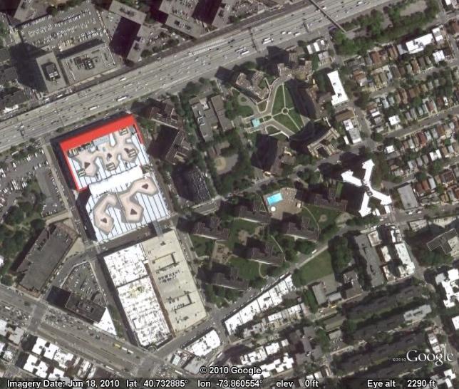
Hot off the heels of early July's imagery update, we've got another batch of new images ready for people to dive into this summer. Have fun exploring the world from Queens, NY to the Queen Hatshepsut's temple in Egypt.
Queens, New York
Queen Hatshepsut's temple in Egypt
High Resolution Aerial Updates: USA: Salt Lake City, Fort Worth, Abilene, Cleveland, New Jersey, and the New York boroughs of Staten Island, Brooklyn, Queens, and the Bronx New Zealand: Otaki
Countries receiving High Resolution Satellite Updates: Mexico, Cuba, Honduras, Jamaica, Haiti, Dominican Republic, Venezuela, Colombia, Peru, Brazil, Chile, Uruguay, Argentina, Norway, Morocco, Algeria, Libya, Egypt, Nigeria, Democratic Republic of the Congo, Mozambique, Russia, Iran, Uzbekistan, Pakistan, India, Nepal, Bangladesh, China, Vietnam, The Philippines, and Australia
Countries receiving Medium Resolution Satellite Updates: Brazil, Sweden, Ethiopia, Tanzania, Tajikistan, and Laos
For a complete picture of where we updated imagery, download this KML for viewing in Google Earth.
Posted by Matt Manolides, Senior Geo Data Strategist
Editor’s Note: Brant Mitchell is Associate Deputy Director of the State of Louisiana Department of Homeland Security. The state of Louisiana Department of Homeland Security is a Google Earth Enterprise customer that leverages Google Earth Enterprise for emergency preparedness and now becomes the first Google Earth Enterprise customer to create a Google Earth Enterprise globe specifically for the public.
For the last three years the State of Louisiana has provided our first responder community a secured access to Federal, State and local geospatial data and high resolution imagery of Louisiana through a Google Earth Enterprise client. In preparation of hurricane season, Louisiana is pleased to announce that we have launched the first public version of a Google Earth Enterprise platform.
Louisiana Earth was released as part of the state's "Get a Game Plan" campaign, to assist citizens in creating evacuation plans by providing access to all of the states evacuation routes, sheltering points historical hazard data and other information that is essential during an evacuation such as locations of and available occupancy of hotels, gas stations, pharmacies, grocery stores, veterinary clinics and banks.
Louisiana Earth will also serve as a mechanism to relay critical data during disasters to help inform the public on the status of response and recovery efforts. Using the Deepwater Horizon Rig incident as an example, there is existing data that Louisiana is making available which includes the latest oil sightings from aerial observations, oyster bed closures, as well as critical environmental data such as bird nesting areas.
During hurricanes and other natural disasters, Louisiana will be able to provide information such as the location of points of distribution (PODs), food stamp offices, unemployment claims offices, disaster recovery centers as well as the status of parishes' power outages as an example.
Finally, while the primary purpose is to utilize Louisiana Earth as a mechanism to provide critical data during emergencies, it will also be utilized to promote Louisiana. We will constantly be adding data that the public can use to take advantage of the many activities and events, such as festivals, that are available in Louisiana.
Louisiana Earth already has information on all of the state parks which consists of lodging accommodations, hiking trails, and camping sites. Historical data and cultural events will also be included and will continue to be updated.
When we started the "Send-To-Car" service on Google Maps more than three years ago with BMW, only a few car makers offered connected services to their drivers. The industry has come a long way since then. Several car manufacturers have made industry-changing commitments to bringing connectivity to the majority, if not the entirety of their car line.
We see more and more cars with connected navigation and entertainment systems leaving the assembly line and the trend is here to stay. That's fantastic news for both drivers and the automotive industry.
The Google Maps Send-To-Car service has grown, and many car manufacturers have joined over time. Just recently, we announced Audi's connected car navigation system which includes Send-To-Car, and the Google Automotive team is thrilled to announce that we have extended the partner base of our Google Maps Send-To-Car service further to include Ford and GM.
As of today, drivers of Ford, Lincoln and Mercury vehicles in the US enabled with Ford SYNC can now send business listings or addresses found on Google Maps directly to their cars.
(Photo credit: Ford)
In addition, millions of OnStar equipped GM vehicles can now make use of this innovative service. Great news if you own a Buick, Cadillac, Chevrolet, GMC, Hummer, Pontiac, Saab or Saturn! Check out this GM video to see the service in action:
Drivers can then use their car maker's turn-by-turn navigation system to be guided to their selected destination. With today’s additions, drivers can send destinations from Google Maps directly to their connected vehicles in 19 countries and more than 20 different brands.
In the US alone, Send-To-Car is now available on more than 15 car brands and we hope to see even more partners join us soon.
We think this is a great convenience for drivers - Prepare your route at your desk, send the destination to your car, and safely enjoy your ride - hands on the wheel, eyes on the road.
We also like to think that in the age of green driving, not having to print paper directions anymore is a great start of a green trip!
You can find more information on Send-to-Car on the Google Maps help center.
Drive safely!
Posted by Markus Mühlbauer, Engineering and Product Manager
A few months ago we released a new type of aerial imagery to our users, first to the developer community through the Google Maps API, and then later as an experimental feature in Google Maps Labs. Today, we’re excited to announce the release of 45° imagery of select cities in the U.S. and worldwide to all users of Google Maps. As you may have guessed from the name, 45° imagery is imagery depicting a location from a 45° angle rather than from the top. This type of imagery allows you to explore the sides of buildings and other locations -- you can even rotate around a particular point of interest using the compass ring to view it from four different perspectives. To see the new imagery, simply zoom into an area while in Satellite mode. Where we have 45° imagery available, the imagery will switch from an overhead to 45° angle as you zoom all the way in. You can then pan smoothly across the map to get a richer view of the area. Here are a few of my favorite spots:
See below for a map of areas where 45° imagery is currently available.
View 45° Imagery on Google Maps in a larger map. 45° imagery is available for portions of the U.S., Europe and South Africa.
We think you will find this imagery particularly helpful when exploring a new area on the map before a visit. After checking out the landmarks from a new angle, it’s helpful to turn on existing map layers like Photos or Wikipedia to get more context on the area. Even when looking at familiar areas, seeing driving directions overlaid on 45° imagery will give you a whole new understanding of the neighborhood. As we expand our coverage over the coming months, I hope you enjoy this new perspective on the world.
In May we announced that we had mistakenly included code in our software in Street View cars that collected WiFi payload data. As soon as we discovered our error, we not only stopped collecting WiFi data entirely, but also grounded our fleet of cars globally to give us time to remove the WiFi scanning equipment and discuss what had happened with local regulators.
The WiFi data collection equipment has been removed from our cars in each country and the independent security experts Stroz Friedberg have approved a protocol to ensure any WiFi-related software is also removed from the cars before they start driving again. *
Having spoken to the relevant regulators we have decided to start Street View driving in Ireland, Norway, South Africa and Sweden again starting next week. We expect to add more countries in time. Our cars will no longer collect any WiFi information at all, but will continue to collect photos and 3D imagery as they did before:
Photos: so that we can build Street View, our 360 degree street level maps. Photos like these are also being taken by TeleAtlas and NavTeq for Bing maps. In addition, we use this imagery to improve the quality of our maps, for example by using shop, street and traffic signs to refine our local business listings and travel directions; and
3-D building imagery: we collect 3D geometry data with low power lasers (similar to those used in retail scanners) which help us improve our maps. NavTeq also collects this information in partnership with Bing. As does TeleAtlas.
We recognize that serious mistakes were made in the collection of WiFi payload data, and we have worked to quickly rectify them. However we also believe that Street View is a great product for users, whether people want to find a hotel, check out a potential new home or find a restaurant. If you want more information about driving schedules, please look here http://maps.google.com/streetview.
*We've updated this paragraph to clarify that both the hardware and software will have been removed from all Street View vehicles before they resume driving.
Posted by Brian McClendon, VP of Engineering, Google Geo
As a former professional cyclist, nothing beats the thrill of being in the peloton and racing towards the finish line. Although I’ve traded in my cycling career for life as a Googler, I’m still a fan and enjoy watching my former teammates and friends battle in races like the Tour de France, which started on Saturday. While the cyclists were preparing to tackle the pave of Arrenberg and the Cols in the Alps, I got to thinking about ways that we can bring that experience to the hundreds of millions of fans who will be following the Tour de France over the next few weeks. Google is home to many other cycling enthusiasts, so we got together to work on ways to build a My Tracks-based gadget that will allow all the other fans to follow the action like never before.
The My Tracks application for Android phones lets you record and share your own outdoor activities, and now Team HTC-Columbia will use a special version of the app with SRM to transmit their telemetry and location in real-time as they make their way through the 3,642 kilometers of the Tour de France. The nine riders (sadly, now eight, as Adam Hanson was injured on Sunday) on Team HTC-Columbia are carrying HTC Legend phones with ANT+ that use My Tracks to capture their location along with their power, heart rate, cadence and speed. On www.google.com/mytrackstour, you’ll see a Google Map showing the team members’ location on the course and a detailed telemetry report. You can observe how Michael Rogers’ heart rate spikes as he attacks the climbs in the Alps on Stage 9, see how many watts Mark Cavendish puts out in the sprint on the famous sprinters’ stage into Bordeaux, and see just how fast riders climb the famous Col du Tourmalet.
From the image above, you can see how Maxime Monfort took the lead during Stage 2 between Bruxelles and Spa yesterday. Right now, the riders are racing in Stage 3, which takes them across the border into France and you can follow all the latest action on our website or directly on your own iGoogle page.
The team also built a map gadget that is available for you to embed on your own website or blog. We’re also publishing an API that any web developer or broadcaster can use to build their own custom application or use to enhance the live television coverage. I'm excited about the potential for web developers and broadcasters to make use of the API and data in creative ways to help all the Tour de France followers (myself included!) get even closer to the action.
This project was the work of many Googlers in their 20% time, and as cycling fans ourselves, we’re happy to be able to share it with the world. We hope you enjoy this unique way of following Team HTC-Columbia over the next few weeks.
We’re happy to announce our latest imagery update, and with America’s 234th birthday today, it’s fitting that we’ve got some great updates for over a dozen cities in the US. Maybe I just have summer travel on the brain, but much of what caught my eye relates to transportation. From left to right, enjoy an airshow in Everett, WA north of Seattle, the battleship New Jersey docked in Camden, NJ near Philadephia, and the Goodyear Blimp off the coast of Miami:
There’s also beautiful imagery of some of the places your family might be interested in visiting, such as the Gateway Arch in St. Louis, the Epcot Center in Orlando, or a tailgate before a baseball game in Philadelphia:
You’ll also find updates in several countries around the globe. One that we found notable is the Three Gorges Dam on the Yangtze River in China:
This imagery is now live in Google Earth and will be available in Google Maps shortly. Of course, if you’re looking at it in Google Earth, don’t forget to use the Historical Imagery feature to compare the newest imagery to what we had before.
Whether today is just another Sunday for you, or you'll be taking in fireworks to celebrate your country’s national holiday, have a happy Fourth of July!
Posted by Jesse Friedman, Product Marketing Manager