Thursday, March 10, 2011

Check in, gain status, and unlock offers with Google Latitude in Austin


Do you have a go-to restaurant you love – a place where everybody knows your name? If you’ve been checking in there from Google Latitude in Google Maps for Android, we want to help you get a little extra love right back. After launching check-ins for Latitude last month, today we’re rolling out our first check-in offers at more than 60 great places in Austin, Texas.

Checking in from Google Latitude lets you easily share the places you go with friends, and you can even choose to get check-in notifications or automatically check in to make it even easier. In addition to sharing places, you can also gain status as a “Regular”, “VIP”, or “Guru” at places depending on how often you’ve checked in there. You can even see your progress along the way by tapping your current status. I’ve been checking in almost everywhere I go, and after a steady stream of caffeination at my favorite coffee shop, I’m proud to be a Guru there!


From the Place page, find available check-in offers (left); tap your status to see where you stand and find your check-in history (right).

In addition to pride, you can now unlock check-in offers that places have created for your status level. So, a restaurant or shop can give their Regulars a reason to keep coming back and their Gurus an awesome reward for their loyalty. Check-in offers can be as creative as places want for any of the three status levels. You can find places where check-in offers are available in Google Maps for Android search results and Place pages.

See if a place has check-in offers available in your Google Maps for Android search results.

You’ll be able to see both available and locked check-in offers. And once you gain status and unlock a check-in offer, just tap Redeem and show your phone to use it. Learn more at google.com/mobile/checkin.

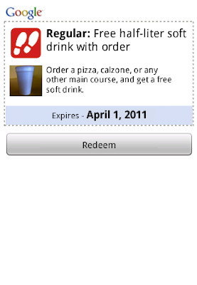
See locked offers and ones available at your status level (left); tap an unlocked one and redeem it (right).

We’re kicking off check-in offers in Austin this week, and we’re working on bringing them to more people and more places. If you’re in town for South by Southwest this week or just happen to live near Austin, find check-in offers at some of its finest establishments, such as:
  • Free coffee for Regulars at Frank
  • Free sundae from the cafe for VIPs at Toy Joy
  • Buy a slice and get one free during certain hours for VIPs at East Side Pies
  • 10% off any upcoming event book for Gurus at BookPeople
  • 20% off select merchandise for Gurus at Waterloo Records
Find all the check-in offer locations in Austin on a map, and then see more details by opening their Place pages in Google Maps for Android.

To get started unlocking offers, update to Google Maps 5.2 in Android Market (requires Android 1.6+) and tap Check in here from a Place page or from Latitude’s menu. If you haven’t yet, join Latitude and check in wherever you go. And if you’ve got an iPhone, the Latitude app for iPhone will be updated with check-ins and check-in offers soon.

Posted by Kenny Stoltz, Product Manager, Google Maps Team

Visit the Hiroshima Peace Memorial in Street View


We’ve added many historic sites to Street View to let you explore these places online, and now we’ve included Street View imagery of the Hiroshima Peace Memorial,  also known as the “Atomic Bomb Dome.” On August 6, 1945 at 8:15am, the first nuclear device to be used in warfare exploded almost directly above this building. The annihilated structure became an iconic symbol of the bomb’s devastation, and despite rebuilding the rest of the city, Hiroshima decided to keep the Dome in its post-war condition to stand as a living testament to the horror of nuclear conflict.


The Atomic Dome has always been an important reminder of history, but also a living beacon for the message of global peace. The desire to experience the Peace Memorial as a physical space makes it a great match for Street View, which both enables people around the world to tour the site virtually and also preserves this important imagery for the next generation. We hope that the imagery will inspire users outside of Japan take a new interest in Hiroshima’s history and think deeply about the importance and meaning of peace.

Along with this Atomic Dome imagery, we have also added special collections of seven places in Hiroshima Prefecture, including Hiroshima Peace Memorial Park and the “floating” Itsukushima Shrine at both high and low tide.

Posted by Setsuto Murai, Strategic Partner Development Manager

Wednesday, March 9, 2011

Find electric vehicle charging stations on Google Maps

[Cross-posted from the Google.org Blog]

At Google, we’ve been supporting environmentally-friendly cars through initiatives such as RechargeIT, an effort to accelerate the adoption of electric vehicles. As consumers embrace electric vehicles, we’ve also been adding information to Google Maps over the past few months to help users find charging stations. Just search on Google Maps for “ev charging station” plus the appropriate area, for example, “ev charging station near mountain view ca.”


We’d like to continue adding more charging stations to Google Maps, so we’re excited that our friends over at the the U.S. Department of Energy’s National Renewable Energy Laboratory (NREL) are working to make more data available.

NREL has launched the GeoEVSE Forum to help develop a detailed, accurate database of electric vehicle charging stations. We’ll be adding more EV charging locations to Google Maps as their database, and others, are updated. As always, you can use the Report a problem tool to inform us of any corrections.

If you represent an automaker, an electric vehicle charging station manufacturer or installer, an EV consumer group or any other interested party, you can join the GeoEVSE Forum by visiting this site.

We look forward to adding even more information to Google Maps to help you recharge your electric vehicle. Happy green driving!

Posted by Cynthia Yeung, Strategic Partner Development Team

Tuesday, March 8, 2011

100 years of celebrating women

[Cross-posted from the Official Google Blog]

As today’s doodle shows, we’re very excited to celebrate the centenary of International Women’s Day. Late last month we teamed up with Women for Women International to announce the Join me on the Bridge campaign, a celebration of the achievements of women taking place on bridges around the world. Since then almost 300 bridge events in more than 50 countries have been added to the map. I’ve found it inspiring to watch all of those little red pins pop up, knowing that each of them represents a group of women and their supporters coming together to let the world know how far we’ve come.


In addition to the flagship events happening throughout the day on the Brooklyn Bridge (New York), the Millennium Bridge (London) and the Golden Gate Bridge (San Francisco), women and men are gathering in places as far-flung as Kabul, Afghanistan, La Paz, Bolivia and Sydney, Australia.

It’s not too late to join the celebrations and show your support—simply find an event on the map. Remember to “check in” to the event on the map before the end of the day, and if you have photos or videos of an event, it’s easy to share them with the world: just click on the pin for the event you attended (or want to support virtually) and start uploading.

We hope you’ll also consider donating to one of the more than 40 incredible women’s organizations participating in our celebration. You can learn more and make a donation at google.com/iwd2011.

Plus, when you use Google Maps on March 8, you’ll notice that Pegman, Street View’s trusted guide, has a new friend. He invited his colleague Pegwoman to join him on the map today to celebrate International Women’s Day!

Post-earthquake images of Christchurch, New Zealand


We’ve been closely following the news about the damage from the magnitude 6.3 earthquake on February 22. We recently published new satellite imagery over the affected area to show an aerial view of the impact. To view this high-resolution imagery, courtesy of our partners at GeoEye, download this KML and explore it in Google Earth. You can also have a look at this Picasa album of before and after shots. Here’s an example of what you’ll see:


Before and after shots of the central business district. The north-south street is Manchester Street.

As a response to this recent catastrophic event, our Crisis Response team also worked quickly to get important information, relevant news and helpful resources to those affected by the disaster and those following developments in New Zealand. We released Person Finder three hours after the earthquake to help people connect with their loved ones. We hope this new updated satellite imagery is valuable for aid workers and the public for illustrating the extent of the damage.

Monday, March 7, 2011

You’ve got better things to do than wait in traffic

[Cross-posted from the Official Google Blog and the Google Mobile Blog]

Ever been stuck in traffic, only to find out you’d have been better off going a bit out of your way to take a less congested route? If you’re like me, you probably hear the traffic report telling you what you already know: traffic is bad on the road you’re currently on, and you should have taken another. It doesn’t need to be this way, and we want to help. So we’re happy to announce that Google Maps Navigation (Beta) will now automatically route you around traffic. With more than 35 million miles driven by Navigation users every day, this should add up to quite a bit of time saved!

On a recent trip to New York, I was running late to meet some friends at the Queens Museum of Art. I had no idea that there was a traffic jam along the route I would normally have taken. Thankfully, Navigation routed me around traffic. I didn’t even have to know that there was a traffic jam on I-495, and I got to enjoy a much faster trip on I-278 instead.


Navigation now uses real-time traffic conditions to automatically route you around traffic.

You don’t have to do anything to be routed around traffic; just start Navigation like you normally would, either from the Navigation app or from within Google Maps. Before today, Navigation would choose whichever route was fastest, without taking current traffic conditions into account. It would also generate additional alternate directions, such as the shortest route or one that uses highways instead of side roads. Starting today, our routing algorithms will also apply our knowledge of current and historical traffic to select the fastest route from those alternates. That means that Navigation will automatically guide you along the best route given the current traffic conditions.

Not only can you save time and fuel, you’re making traffic better for everyone else by avoiding traffic jams. Keep in mind that we can’t guarantee that Navigation will be able to find a faster way, but it will always try to get you where you’re going as fast as possible.

You can begin routing around traffic with Google Maps Navigation for Android in North America and Europe where both Navigation and real-time traffic data are available.

Enjoy your newly found free time!

Thursday, March 3, 2011

Tweet your Hotpot ratings in Google Maps for Android


(Cross-posted from the Google Mobile Blog.)

Whether it’s Google Places with Hotpot or Google Latitude, we’re working on helping you connect the people you care about with places you love. Now, when you’re rating your dinner spot using Google Maps for Android, you can share your review with even more people by posting it to Twitter.

Post your ratings and reviews to Twitter
When you rate and review places like restaurants or cafes from Google Places, you can share valuable recommendations with your Hotpot friends and across Google’s products – in search results, on google.com/hotpot, and on Place pages. But we wanted you to be able to share your recommendations even more broadly. So today, you can start sharing your ratings and reviews with your followers on Twitter directly from your Android-powered device.


When rating on the go using our rating widget, just choose to Post review to Twitter and connect your Twitter account. You’ll get a preview of your tweet and will be able to post your ratings and reviews moving forward.

Post your ratings and reviews to your Twitter followers.

Check-ins: ping friends and search for places

Starting last month, you could share information about the place you were at, in addition to your location, by checking in at places using Google Latitude. Starting today, if you see nearby Latitude friends on the map and want to ask them where they are, you can quickly “ping” them instead of having to text or call. They’ll receive an Android notification from you asking them to check in at a place. And when they check in using your request, you’ll get a notification right back so you know which place to go to meet up with them.

From a friend’s Latitude profile, ping them (left) and they’ll receive a notification (right).

You’ll also be able to more easily check yourself in at the right place. Sometimes there are a lot of nearby places around you, and the right one is missing from the suggested list of places to check in. You can now quickly search for the right place using the Search more places button.

Search for the right place to check in if it’s not among the suggested places.

To start posting Hotpot ratings to Twitter and pinging Latitude friends, just download Google Maps 5.2 from Android Market here (on Android OS 1.6+ devices) everywhere it’s already available. Please keep in mind that both Latitude friends need version 5.2 in order to use the new “ping” feature. Learn more in the Help Center.