Wednesday, May 12, 2010

Save the Date: Google Geo Teachers Institute, July 21-22


For years, Google's Geo products have been identified as a powerful learning toolkit that can help students conceptualize, visualize, share, and communicate information about the world around them.

This July, Google is hosting the first Google Geo Teachers Institute. This event is a FREE professional development experience designed to help educators get the most from Google's Geo products and technologies. The Geo Teachers Institute is an intensive, two-day event where participants get hands-on experience with Google's Geo products: Google Earth, Google Maps, and SketchUp, including a focus on features like Mars, Moon and Sky in Google Earth. Attendees will learn about innovative instructional strategies and receive resources to share with colleagues. The Google Geo Education team hopes this event will empower educators to bring the world's geographic information to students in a
compelling, fresh, and fun way.

To apply, send email to geoedu@google.com.

Tuesday, May 11, 2010

Local marketing 101 at “Local University”


If you manage a small business and happen to be in the Minneapolis/St. Paul area on May 13, come check out the Local University event, at the Westin Edina Galleria. I’ll be there to give tips and tricks for using Google Places most effectively, and will be joined by my counterpart from Bing’s Local Listing Center, as well as respected leaders of the local search field (you can see the full list of“faculty” here.)

There will be two identical half-day sessions (8am - noon and 1pm - 5pm) on May 13th, 2010. The regular price is $129 but if you use coupon code LatLong at checkout, you’ll save $40. You can get more details and register at this link.

This event is part of a nationwide series of events which are organized by GetListed.org, as a primer for business owners who wish to use the internet effectively to promote their business. Keep an eye out for the university to come to an area near you.

Google Maps for Android Gets Biking Directions, Navigation Shortcut, Sharing, and More

[Cross-posted from the Google Mobile Blog]

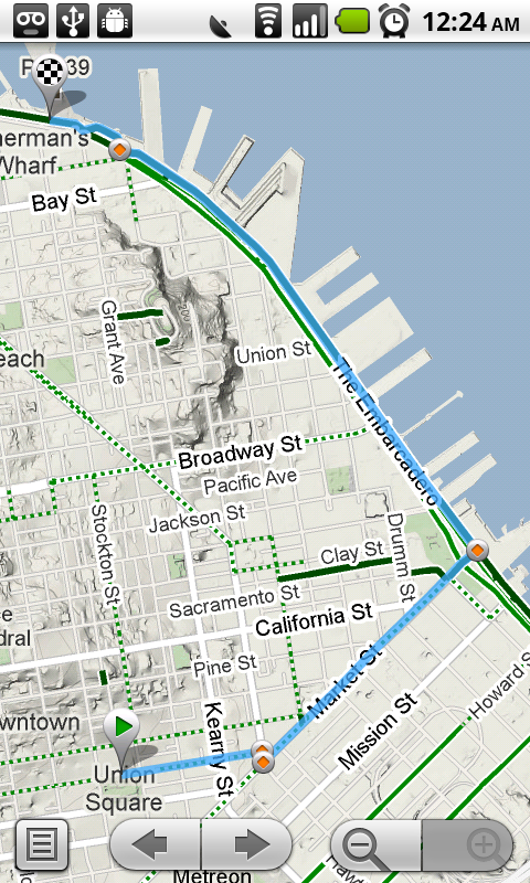
Starting today, Google Maps for mobile has a few new ways to help you and your friends quickly get to where you’re going whether you’re on 4 wheels or 2 (or maybe even 3). With Google Maps 4.2 for Android you can now get biking directions on the go, start Navigation from your Home screen, share places with friends, and more.

Biking directions
Since launching biking directions on desktop Google Maps, we’ve wanted to get you biking directions, lanes, and trails on your phone too. Just in time for National Bike Month, select the bike icon when getting directions to get an optimal bicycling route in the U.S. If you’re in the mood for a more scenic ride, you’ll also see the Bicycling layer on the map which shows dedicated bike-only trails (dark green), roads with bike lanes (light green), or roads that are good for biking but lack a dedicated lane (dashed green). You can always turn on this layer from the Layers menu to pick your own route. Add in the Labs’ Terrain layer, and you can decide to either climb or avoid that big hill on the way home!


Google Navigation shortcut
If you’re driving instead of riding, we wanted to make it easier and faster for you to get on the road with Google Maps Navigation as soon as you’re ready. With the new Navigation shortcut, you can pick a destination and be on your way with as little as 2 taps of your finger. Select the “Navigation” icon in your phone’s app launcher to get the new destination selection view. Then, speak or type your destination, pick one from your contacts, choose a starred place, or select a recent destination. Navigation will begin and you’re good to go. Make it even easier on yourself by adding the Navigation icon right on your Home screen.


Sharing
Once you figure out where you’re going, why not get some friends to meet you there? From any search results page, choose to “Share this place” to send that place’s info, such as its address and phone number, to whomever you like. If you want to meet someone on a street corner or gather friends at an outdoor concert, you can also send an exact location from the map -- even a snapshot of your current location. Just use the share option after selecting a point on the map, your “My Location” blue dot, or yourself in Latitude if it’s enabled. Whether you’re sharing a place or a location, you’ll be able to send it to small groups via an email or text message or send it widely with apps like Google Buzz, Facebook, or Twitter.

Get these new features by searching for Google Maps in Android Market from Android 1.6+ phones (On your phone now? Tap here). Update Maps to version 4.2, available in all the countries and languages where Maps is currently available. Visit our Help Center to learn more, ask questions in our Help Forum, or give us suggestions and vote on other people’s on the Mobile Product Ideas page.

Friday, May 7, 2010

How big is the Deepwater Horizon oil spill?


Crude oil from the Deepwater Horizon oil rig explosion continues to leak into the Gulf Coast. Official estimates state a rate of 200,000 gallons a day, while some private estimates think it could be over a million gallons each day. The spill covers an area of over 2,500 square miles, and shows no signs of slowing down.

2,500 square miles is a large number, but how big is that, really? It's very difficult for us to imagine something that large, and it's doubly hard to grasp the true size when it sits over the vast ocean surface.

To help understand the scale of this ecological disaster, I built a page using the Google Earth Browser Plug-in that will let you see the oil spill in comparison to something everyone has a good grasp on: the size of your own home town. Also, you can compare the oil spill to some very large cities around the world -- is it bigger than San Francisco, New York, London? You'll be surprised at what 2,500 square miles really means.

And it's still growing.


See it here: http://paulrademacher.com/oilspill. If you’re interested in learning more from Google or our data providers, you may want to check out these following sites:


Wednesday, May 5, 2010

Five continents and counting - new cities in Building Maker

[Cross-posted from the SketchUp Blog]

You might have noticed that the Building Maker team has been quiet on the city front in the last month. Well, we’ve been working behind the scenes to make our next set of cities available for modeling. With 11 new cities, Google Building Maker has extended its coverage to include nine new cities in South Africa and two new regions (plus added coverage of two existing regions) in California.


Whether you want to explore the Victoria & Alfred Waterfront in Cape Town, model the cities where the Springboks play or explore the venues of another sporting code, now is your chance. Go to Google Building Maker and choose one of these cities from the top-right drop-down menu or click on a red pin to zoom down. The new cities in Building Maker are:

South Africa

  • Bloemfontein
  • Cape Town
  • Durban
  • Johannesburg
  • Nelspruit
  • Phokeng
  • Polokwane
  • Port Elizabeth
  • Pretoria


California
  • Oakland
  • Berkeley
  • San Francisco (extended coverage)
  • Redwood city (extended coverage)
Happy modeling!

Google & Small Business Administration partner to share tips with businesses

(cross-posted from the Google Policy Blog)

Ben and Jerry turned a $5 correspondence class in ice cream making into a multi-million dollar business. Phil Knight, the founder of Nike, sold sneakers out of the trunk of his car at track meets. And, like many silicon valley startups, Google got its start, literally, in a garage.

Every business starts small and sometimes, with a little luck, they catch on. One way to make sure your business has the best possible chance of success is to make sure it has a strong web presence. A new generation of tools geared especially for even the smallest businesses make this easier than ever. They are easy, low-cost and often completely free and they can ensure that consumers can find you online and learn about what you do.


These tools are great for small business and for our economy and that's why we've teamed with the U.S. Small Business Administration to create a website featuring video testimonials by small business owners who are using online tools to attract more customers. The goal of the partnership between Google and the SBA is to help small businesses understand the tools and resources available to them online and learn savvy tips from other small business owners.
  • Establish your online presence. One out of five searches on Google are related to local information. Massive numbers of consumers are using the Internet to search for everything from taekwondo classes on the south side of town to a trusted vet for the family pet. Small and large businesses can easily create a rich online presence using tools like Google Places and, for businesses that want to take the plunge and create a full-blown website, ready-made site templates and free hosting services like Google Sites make creating one painless and fast.
  • Use free marketing to reach customers. You can build a fan base for your business with free services like YouTube, Facebook and Twitter that will keep your customers in-the-know about new products and special promotions. These services are great "word of mouth" platforms that make it easy for a customer following your business to tell their friends about it.
  • Understand your customers. Online tools can make you smarter about your customers by analyzing the search terms they use to find you and the pages they visit on your site. This data can help you tune your offers and site to what's truly popular and can be used to help you select terms for online search advertising such as Google AdWords.
In addition to the videos, Google also produced a “Tools for Online Success” booklet that will be in nearly 1,000 SBA, SCORE, and Women's Development Centers nationwide. The booklet offers online tips and tricks for businesses of any size.

Tuesday, May 4, 2010

Mapping the Gulf oil spill in Google Earth

[Cross-posted from the Official Google Blog]

Two weeks ago, there was a fatal explosion on the offshore oil rig Deepwater Horizon in the Gulf of Mexico. The rig sank shortly afterwards, and since then the well has been leaking crude oil into the Gulf, spreading an oil slick towards the U.S. Gulf Coast. This spill is pouring as many as 5,000 barrels (210,000 gallons) of oil a day into the Gulf and poses a serious threat to coastal industries, sensitive habitats and wildlife, including numerous species along the coastal areas of Louisiana, Mississippi, Alabama and Florida. Many government agencies and other organizations have made data publicly available, which we’ve compiled on our crisis response site dedicated to the spill.

Last week we made imagery from NASA’s MODIS available as an overlay for Google Earth, which currently shows the extent of the oil spill through April 29, and we’ll continue to add more imagery as it becomes available. We’ve also made radar images from ESA’s ENVISAT available through this KML file. Below, you can see the progression of the spill over time.


To view this imagery and other datasets in Google Earth, turn on the “Places of Interest” layer in the Layers panel on the left-hand side of Google Earth, then navigate to the Gulf of Mexico and click on the red icon.


In addition to this imagery, our site contains maps of the locations of the oil, fishing closures and affected areas, the ability to upload videos directly to YouTube, and a link to a site where people in the area can contribute their observations. We hope these resources are useful to those affected by the spill, those responding to it and those learning about its devastating effects on the people and environment of the Gulf Coast.