(Cross-posted on the Official Google Blog)
This Valentine’s Day, tell your friends, family or significant other that you love them with a fun message from Google Maps.
Location can be a powerful trigger of memories—from the Italian place in San Francisco where you went on your first date to the cabin you rented at Lake Tahoe with your roommates. For that reason, we thought it would be great to create a Valentine’s Day card that’s tied to a specific location. As long as there’s a place that means something special to you and the ones you love, mapping your valentine is a great way to make Valentine’s Day a little more special.
One of my favorite memories is from a family trip we took to Eilat in Israel (check out my awesome fashion sense, I’m on the far left...), so I sent my parents this card:
I hope you'll take a moment to remind the people you love of the places you've shared with them. Visit www.mapyourvalentine.com to get started.
Happy Valentine's Day from Google!
Monday, February 14, 2011
Friday, February 4, 2011
Geotagging photos with Panoramio and Google Latitude
[Cross-posted from the Panoramio Blog]
It is 9 a.m. and the thermometer shows -15°C. I have a Nexus S with Google Latitude in my left pocket and my new Lumix LX-5 in the right one. I am in Davos and I am ready for a fantastic day of skiing when I decide to use the new feature of Panoramio: geotagging photos with Google Latitude.
Panoramio is a community photos website that enables digital photographers to geo-locate, store and organize their photographs -- and to view those photographs in Google Earth.
Google Latitude allows you to share your location with friends and view their location on a map. When enabled, Google Latitude History allows you to store your previous locations and this allows you to match your photos with the locations stored in Google Latitude History.
By combining Panoramio and Google Latitude your photos get geotagged automatically as the time stamp of the photos is matched with your location record in Google Latitude History. To use this feature you need to explicitly enable it in your Settings page in Panoramio. With your permission, Panoramio will access your Google Latitude History to find out your location at the time when your photos are taken, so make sure the time in your camera is correct and it matches the value you entered in the Panoramio Settings page.
Using Google Latitude while skiing allows you to find your friends when you get lost on the slopes, and at the same time it allows you to focus on taking nice photos not worrying about the location where you are taking them.
Mapping photos within the city is normally not a problem as you can easily remember street names, points of interest, etc. It is much more difficult to do it in the countryside and that is why I decided to give the feature a whirl while skiing in Davos:
Thanks to Google Latitude, my photos were geotagged just after uploading them in Panoramio. The day was great, snow was perfect, weather was amazing and when I arrived home my photos were already geo-positioned.
For more information about this feature please check our help content and as always we will be happy to hear your feedback in the Panoramio forum.
It is 9 a.m. and the thermometer shows -15°C. I have a Nexus S with Google Latitude in my left pocket and my new Lumix LX-5 in the right one. I am in Davos and I am ready for a fantastic day of skiing when I decide to use the new feature of Panoramio: geotagging photos with Google Latitude.
Panoramio is a community photos website that enables digital photographers to geo-locate, store and organize their photographs -- and to view those photographs in Google Earth.
Google Latitude allows you to share your location with friends and view their location on a map. When enabled, Google Latitude History allows you to store your previous locations and this allows you to match your photos with the locations stored in Google Latitude History.
By combining Panoramio and Google Latitude your photos get geotagged automatically as the time stamp of the photos is matched with your location record in Google Latitude History. To use this feature you need to explicitly enable it in your Settings page in Panoramio. With your permission, Panoramio will access your Google Latitude History to find out your location at the time when your photos are taken, so make sure the time in your camera is correct and it matches the value you entered in the Panoramio Settings page.
Using Google Latitude while skiing allows you to find your friends when you get lost on the slopes, and at the same time it allows you to focus on taking nice photos not worrying about the location where you are taking them.
Mapping photos within the city is normally not a problem as you can easily remember street names, points of interest, etc. It is much more difficult to do it in the countryside and that is why I decided to give the feature a whirl while skiing in Davos:
Thanks to Google Latitude, my photos were geotagged just after uploading them in Panoramio. The day was great, snow was perfect, weather was amazing and when I arrived home my photos were already geo-positioned.
For more information about this feature please check our help content and as always we will be happy to hear your feedback in the Panoramio forum.
Posted by Gerard Sanz, Panoramio Community Manager
Take a trip to the Super Bowl with Google Earth
We’re two days away from one of my favorite events of the year, the Super Bowl (and I’m sure I’m not alone!). I’m one of those fans who starts watching football during pre-season and can have entire weekends ruined if my team loses. For me, the Super Bowl is the culmination of hours spent glued to the television and more hours doing post-game analysis (read: arguments) with fellow football enthusiasts.
However, what I love most about the Super Bowl is the tradition around it. It’s a time when friends and family get together and stuff their faces with nachos and beer, argue about who they wish were performing at halftime and watch the two best teams in the league slug it out for the storied Lombardi trophy. Even the commercials are good!
Unfortunately, not all of us can have the luxury of being at Cowboys Stadium – site of Super Bowl XLV – for the game, so we thought we’d offer users the next best thing: the Cowboys Stadium in 3D for Google Earth. Watch the video below to fly to Arlington, Texas and see the stadium in 3D.
You can also visit the stadium in Google Earth by searching for “Cowboys Stadium, Arlington TX” (make sure the 3D layer is turned on). Or, click here to see the area in your browser with Earth view in Google Maps.
We hope you enjoy the game as much as we will. Oh, and go Packers!
Posted by Gopal Shah, Google SketchUp team
Update: Go Steelers! -Nicholas Whitaker, Chief Steelers Evangelist
Wednesday, February 2, 2011
It’s Groundhog Day!
[Cross-posted from the SketchUp Blog]
Today is the 125th anniversary of Groundhog Day – a tradition in the US and Canada when a weather-predicting woodchuck named Punxsutawney Phil tells us how long winter will last. Every year on February 2, a group of local dignitaries hold a ceremony at Gobbler’s Knob, about 2 miles outside of Punxsutawney, Pennsylvania. Just after sunrise, Phil emerges from his burrow in front of thousands of spectators. The legend states that if Phil sees his shadow, there will be six more weeks of winter. No shadow means there will be an early spring.
Punxsutawney Phil in Google Earth
You can check out Gobbler’s Knob by entering the coordinates 40°55'48.65"N, 78°57'27.53"W into Google Earth or by clicking here to see the area in your browser.
Posted by Zach Moore, 3D Data Specialist
Today is the 125th anniversary of Groundhog Day – a tradition in the US and Canada when a weather-predicting woodchuck named Punxsutawney Phil tells us how long winter will last. Every year on February 2, a group of local dignitaries hold a ceremony at Gobbler’s Knob, about 2 miles outside of Punxsutawney, Pennsylvania. Just after sunrise, Phil emerges from his burrow in front of thousands of spectators. The legend states that if Phil sees his shadow, there will be six more weeks of winter. No shadow means there will be an early spring.
This year, Phil emerged at 7:25 AM and did not see his shadow! Despite the major winter storm stretching across 2,000 miles of the continent, it sounds like we’ll be enjoying an early spring!
You can check out Gobbler’s Knob by entering the coordinates 40°55'48.65"N, 78°57'27.53"W into Google Earth or by clicking here to see the area in your browser.
Posted by Zach Moore, 3D Data Specialist
Tuesday, February 1, 2011
Google Hotpot now on Google.com and around the world
Back in November, we introduced Hotpot, a new local recommendation engine powered by you and your friends. Using Hotpot is simple: you rate places on google.com/hotpot—restaurants, hotels, cafes—and add friends on Hotpot whose opinions you trust. Then the next time you perform a search, Google will serve up personalized results, listing places based on your tastes, as well as recommendations from your friends.
We’ve watched Hotpot grow and change over the last couple months, and today Hotpot is really going places: to a Google search box near you and around the world.
You can now enjoy Hotpot recommendations in your regular search results on Google.com. So say you’re looking for a restaurant in Barcelona. Go to Google and search [restaurant barcelona]. If a friend has rated a particular restaurant, you might see their rating and what they had to say about it—as well as their name and photo—directly beneath that restaurant’s listing. To see all recommendations by your friends, click “Places” on the lefthand side of the page, and choose “Friends only.” Remember, you’ll need to be logged in to your Google account in order to see recommendations.
Seeing place recommendations based on your tastes and those of your friends across more Google searches will make results more relevant to you and maybe lead you to discover a new gem. If you don’t have Hotpot friends yet, you can invite them to share all the places they love with you by using the “Friends” tab on google.com/hotpot.
But Hotpot will only be half the fun if you can’t share it with all your international friends. So starting today, we’re making Hotpot available in 38 new languages—including Chinese, French, German, Italian, Korean, Polish, Russian and Spanish—allowing people to share their favorite places in their native language.
Start rating and sharing recommendations with Hotpot everywhere, anytime: at google.com/hotpot, on Google Maps, using Google Maps for Android with an easy widget, and on our new iPhone app.
Happy rating!
Posted by Lior Ron, Product Manager
Check in with Google Latitude
[Cross-posted from the Official Google Blog]
Connecting your location with places
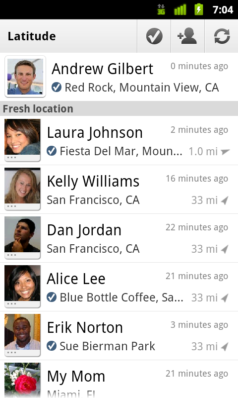
You can still use Latitude to automatically update and share your location, but check-ins let you add context to the location—like captions to a photo. For example, I live in San Francisco but often travel around the world. Until today, sharing my location let friends and family know if I was across the globe or in their neighborhood. Now, check-ins let them see the cool restaurant I’m trying in Taipei or join me for a latte at the cafe nearby.
See where your friends are on a map and where they’re checking in.
Because you can use Latitude to automatically detect your location, we’ve added a few twists to checking in to make it really easy:
- Notifications: Turn on check-in notifications in Latitude’s settings and get a notification to check in at a nearby place once you arrive. Never forget to check in again.
- Automatic check-ins: Choose to automatically check in at specific places you designate, and you’ll be checked in when you’re there. You can talk to friends or finish your bagel without fumbling with your phone.
- Check out: Once you leave, Latitude knows to automatically check you out of places so friends aren’t left guessing if you’re still there.
Explore your world one check-in at a time
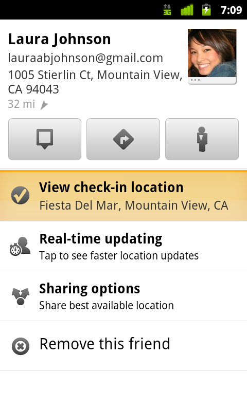
Latitude is built right into Google Maps for Android so check-ins work across Latitude and Maps seamlessly. For example, check in at that new hamburger joint, and you’ll see its Place page with reviews to help you order. When friends check in at a place, you can go straight from their Latitude profile to its Place page to learn about it, fire up Google Maps Navigation (Beta) for turn-by-turn directions to them, and more.
You can also check in at a favorite place to earn special status there; you’ll see if you’ve become a “Regular,” a “VIP” or a “Guru” on its Place page. Keep checking in to hold onto your status or reach the next level.
Latitude check-ins are built right into Google Maps and Place pages.
Choose options for individual check-ins or turn on and off notifications in the Latitude settings.
Start checking in by downloading the latest Google Maps from Android Market (on Android 1.6+; tap here if you're on your phone) and then joining Latitude from the main menu. You can check in everywhere Maps and Latitude are already available. If you’re using the new Latitude app for iPhone, you’ll see your friends’ check-ins, and we’ll update the app soon so you can check in too.
Just the beginning...
Checking in from Latitude is just one step in helping you connect the places you go with the people you care about. We believe in letting you use or share your location however you like, and we’re working on making location and check-ins useful in more places—across Google and the web.
Posted by Joe LaPenna, Software Engineer, Google Latitude Team
Street View takes you inside museums around the world
We’re always excited to share new Street View imagery with users, whether a botanical garden in South Africa or ski slopes in Canada. While Street View has enabled users to visit places all around the world virtually, the demand to show a broader range of popular locations has been great. Today we’re entering new territory with our experiment to take Street View technology indoors.
The Art Project, developed by a group of art-loving Googlers, is a collaboration between Google and 17 of the world’s most acclaimed museums. Select works of art chosen by these partners are now available for you to explore through Street View in Google Maps, and the Art Project site offers an immersive experience to explore museum information, floor plans, more than 1000 high-resolution pieces, and Street View imagery. Learn more about the Art Project on the Official Google Blog.
To take you inside magnificent spaces like the State Hermitage Museum in St. Petersburg, Russia, our team needed to update the way we go about gathering Street View images.
The State Hermitage Museum, St. Petersburg, Russia
Street View imagery is typically collected using cars and we’re able to utilize the ample roof space and interior storage of these vehicles for all of our equipment. To take Street View technology indoors, we needed to fit all of the equipment on a much smaller vehicle, a push-cart lovingly dubbed Trolley.
Pictured with Trolley: Daniel Ratner, Mechanical Engineer and Matt Williams, Program Manager at the Van Gogh Museum in Amsterdam, The Netherlands
Trolley is outfitted with a few components that are key to collecting indoor imagery: a panoramic camera to collect 360-degree views, lasers to capture distances to walls, motion sensors to track Trolley’s position, a hard drive to store data, and a laptop to operate the system.
With this adapted equipment, we were able to gather the imagery and bring it into Google Maps, and you can now drag Pegman directly onto museums like the Metropolitan Museum of Art in New York City to explore their impressive European Paintings wing.
The Metropolitan Museum of Art, New York, United States
You can also enter museums when you’re already looking at Street View imagery of the museum exterior. You’ll notice new double-arrow navigation links from the nearby streets leading you inside, as you can see here for the Palace of Versailles.
Palace of Versailles, Versailles, France
Once inside the museum, you can navigate around rooms freely with the navigation arrows or simply click on a distant spot to jump to a closer view. Movement between floors can also be done with ease by selecting a different level from the new control panel below the Street View compass and zoom controls.
Alte Nationalgalerie, Berlin, Germany
We’re excited to introduce this new imagery in Street View, and will continue to improve and develop this indoor experience. To explore these museums directly through Street View in Google Maps, visit maps.google.com/museums, and to view high-resolution artwork and learn more about the museums, check out the Art Project at www.googleartproject.com.
Posted by Jonathan Siegel, Software Engineer
Subscribe to:
Posts (Atom)