Over the past year, the Google Maps Directions team has been hard at work developing a variety of design improvements to make getting and following directions much easier.
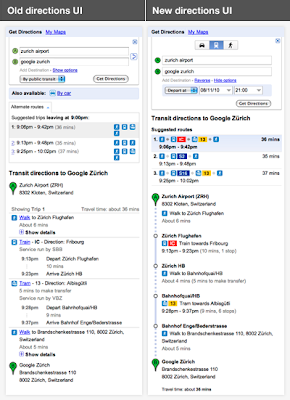
It’s now simpler than ever to switch transport modes, change the time/date of your trip, get a high-level overview comparing different routes, and view details of a single trip at-a-glance.
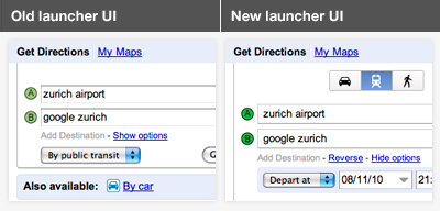
To explore these improvements in more depth, let’s imagine that you’re planning a trip to visit the beautiful city of Zürich, and would like to take public transportation from the airport to your destination in town.
We’ve made it super quick and easy for you to see all the available modes of transportation when you’re planning a route - you can see that driving, public transit, and walking are all available in this area. The options for setting a time and date for your trip are also now open by default for public transit:
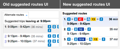
Having selected your start location and end destination, you are presented with a series of suggested routes to take you from A to B. Each description is now much richer, making it easier to differentiate between similar routes:
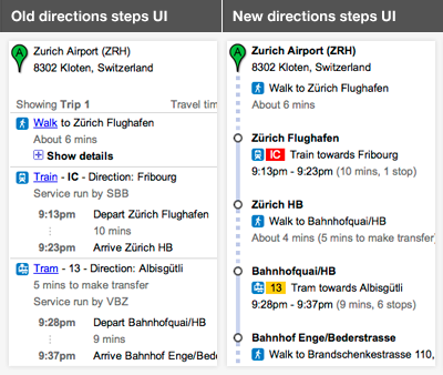
Once you select a route, the individual steps for the trip are dramatically simplified and cleaner in the new design. The stations at which you’ll need to transfer, and the number of stops in between are now much more apparent. The sections of the route that involve walking are also much easier to spot since they’re indicated by a dotted line on the left:
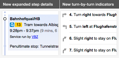
Clicking on any step will also display more information. For example, we now show the stop preceding the one where you’ll need to get off, so that you can get your bags ready and prepare to disembark. And we’ve introduced turn-by-turn direction indicators for walking, driving and cycling:
Stay tuned for further changes as we continue to refine and improve your experience using directions from Google Maps. Enjoy your travels!
Posted by Jonah Jones, User Experience Designer
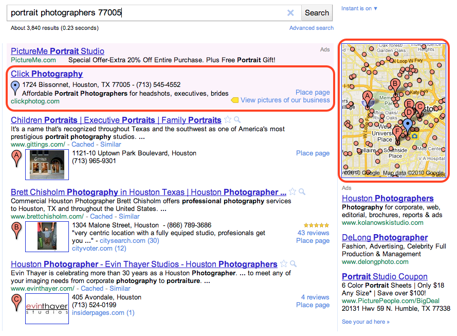
We recently announced that our new search advertising program, Google Boost, is available to local businesses in San Francisco, Houston and Chicago. Based on the great feedback and results from early participants, the beta is expanding to additional U.S. cities. Starting today, select local business owners can sign in to their Google Places account and try Boost if they’re located in San Jose, Seattle, Wichita, Charlottesville (VA), Atlanta, Chapel Hill, Orlando, Washington D.C., Boston, Cross Plains (TX) and Portland (ME). We’ve also made Boost available for all local businesses in Illinois.
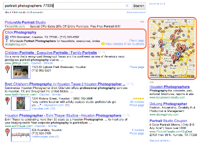 A Boost ad for Houston-based Click Photography, and it’s corresponding blue map pin
For those of you who are not yet familiar with Boost, it’s a quick and easy way for local businesses to market themselves and connect with potential customers in their area. Based on the information you’ve already provided on the Place page for your business, we provide a suggested ad description, a web or Place page, your business categories and a monthly budget. Once you’ve confirmed these four simple elements, our system automatically creates an ad campaign. Your ad may start appearing almost immediately when people in your area search online for products and services related to your offering. And what’s more, you’ll only pay when a potential customer actually clicks on your ad. To be clear, the ranking of Boost ads in the “Ads” section of the Google.com and Google Maps search results pages are based on relevance and quality factors; and Boost ads do not impact the ranking of your free, organic business listings.
Over the next week, eligible businesses in the cities mentioned above will see an invitation to try Boost when they sign in to their Google Places account dashboard. Business owners located outside of these areas can fill out this form to be notified when Boost expands further to their regions.
Posted by Kiley McEvoy, Product Manager
There’s something so exciting about discovering new places. Nothing beats finding a great new place I’ve never been—whether it’s a new bakery with a special dessert, a hole-in-the-wall Mediterranean place I didn’t notice before or a local art gallery where I can let my imagination roam free.
The challenge with finding those great places is that each of us has different tastes. I want to find places I like and I want to find them quickly. So when I’m overwhelmed with possibilities, I turn to sources I can trust. For example, if I’m in a new city, I might chat with the concierge at my hotel and explain to him the kinds of places I like so he can give me personalized recommendations, or I’ll ask my friends for local recommendations because I value their opinions and we have similar tastes. But finding trusted advice is hard; wouldn’t it be great if there was a way for me to get these recommendations all the time, everywhere I go?
We are trying to do exactly that, and today we’re excited to share the first step: an early release of Hotpot - a local recommendation engine powered by you and your friends. With Hotpot, we’re making local search results for places on Google more personal, relevant and trustworthy. There are three main ingredients in the Hotpot recipe:
- Google Places - These are the 50 million places around the world for which we have rich details.
- The places you like - When you rate places you like, we’ll tell you about other related places you’ll love. I love my favorite neighborhood restaurant in Noe Valley, Firefly, so when I rate it 5 stars, Hotpot will try to recommend other places for me in the city with simple, homey food such as Home restaurant.

- The places your friends like - Share your ratings with your friends and see the places they’ve recommended. I’m planning a trip to Barcelona for the holidays and my friend Bernardo is a local. With Hotpot, I can see his recommendations when planning my trip on Google Maps, or when I’m in Spain using Google Maps or Places for Android.
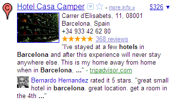
Combining these three ingredients makes the hard task of choosing where to go easy; all you need is to rate places and add your friends. To do that we created the Hotpot rating app: quickly rate all the places you’ve been to and choose exactly which friends you want to invite to Hotpot. Then, when you’re visiting places, you can continue rating on the go from Mobile maps on Android.
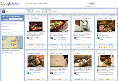 Rate from the Hotpot rating app
 Rate from Mobile maps on Android
Your recommendations are with you whenever you need them. In search results, you can see recommended places by using the new Place Search and clicking on the “Places” filter. You can also see recommendations when searching on Google Maps, Google Maps for Android or when checking the Place pages for a specific business.
 Recommendations on Place Search
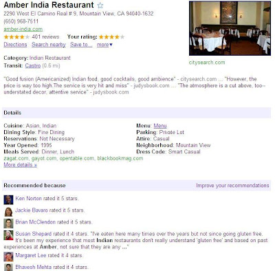 Recommendations on a Place page
 Recommendations on Google Maps for Android
You can set a Places nickname (here’s how) when you start using Hotpot, so you control how you post your ratings. That way, only your friends will be able to see your real name.
Happy hotpotting!
Posted by Lior Ron, Product Manager
Viewing photos in Google Earth has long been a popular activity for avid virtual globe-trotters. It's one of the best ways to "visit" places all over the world without paying for a plane ticket or getting jet lag. Today, the Google Earth photo viewing experience just got better with the addition of panoramic images.
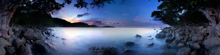
People using Google Earth will find a new "Photos" layer that includes not only the existing 2D photos from the Panoramio community, but also panoramic photos from around the world contributed by users of 360cities.net. These high-resolution panoramic photos are marked in Google Earth as red square icons. When you click on one of these icons, an info bubble containing an image appears, and clicking on the image again will take you into our photo viewing mode. You can then look around in 360-degree views and experience the place as if you’re standing right at the center of it.
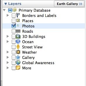 new "Photos" layer on Google Earth
 info bubble on Google Earth
These panoramic photos are shot by average people just like you and me. To contribute your panoramic photos, visit 360cities.net. We invite all users to become part of the community and mark your photo journey in Google Earth.
Check out some of the beautiful images now available right in Google Earth.
Posted by Wei Luo, Senior Geo Data Strategist
Last week, we were informed of a data error regarding the border between Costa Rica and Nicaragua in Google Maps. We said we would update our data for this region. We have now updated the border data on Google Earth, and we are working on updating this border on Google Maps as well.
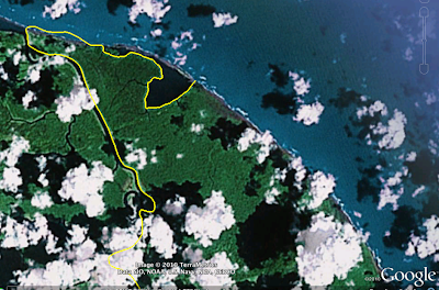
As always, you can report errors about Google Earth through our Data Reporting Page or about Maps through the Report a Problem tool, where available.
Posted by Wei Luo, Senior Geo Data Strategist
We love hearing stories about how people all over the world use Google Earth. Richard Allaway, a teacher at the International School of Geneva - Campus des Nations, recently shared his thoughts on the importance of Google Earth in his classroom. With Google Earth, Richard is able to create a unique experience in which he and his students can travel the world, exploring everywhere from the bottom of the Atlantic Ocean to the peaks of the Smoky Mountains. We loved his story so much, we want to share it with you too!
Here's what Richard had to say:
There are two windows in my classroom. One window looks past the buildings of the International Labour Organization, Geneva's Jet d'Eau, and onwards to the Alps.
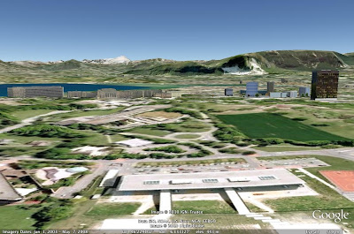 Google Earth’s representation of the view from Richard’s classroom window
Through the other window we can see Mount Etna, the meanders of the Mississippi, all the way to the buildings of Ancient Rome and even significant earthquakes that have happened in the last seven days. This “other” window is Google Earth.
I am a humanities teacher at the International School of Geneva - Campus des Nations working with students ages 11 to 18 years old. But Google Earth is an important tool in any teacher’s toolbox because it provides a free and accessible gateway to far-off places. I use Google Earth to enhance my students’ learning opportunities and help them better understand the places we discuss. From our classroom, we can visit the landscapes that we can’t normally see through the limited viewpoint of a real window.
For example, we’ve taken a tour through the limestone landscapes of the Yorkshire Dales in the United Kingdom. Guided by a Google Earth tour and supporting worksheet, my students explored the unique limestone features and saw for themselves how geological processes shape our environments.
To study the possible eruption of Mount Rainier in the American northwest, we used Google Earth to visualize the hazards and the corresponding management strategies. Students were then challenged to use Google Earth or Maps to plan an escape route for what is considered to be a low-probability, but high-consequence event.
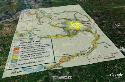 Information in Google Earth about Mount Rainier
GeographyAllTheWay.com is the website I use to organize and deliver my teaching resources. Students can access it from any location, whether they’re at the library, at home, on their computers and on their smart phones. It’s a continually developing project, but also a service that I welcome my fellow educators to use to help support their own lesson planning.
We love hearing inspirational stories like Richard’s, so if you want to share a cool experience you’ve had using Google Earth, tell us - we’re listening!
Posted by Vaishaly Shah, Google Earth Team
Today the Google Maps team is excited to announce that we are releasing a number of improvements to the look and feel of the map for Japan. This redesign is intended to provide our users with an easier to read and more beautiful map, and to help them find the geographic information they want more quickly.
We’ve given a lot of thought to the visuals used to present the multi-faceted information on the Japanese maps, and have arrived at a refined set of style updates for the typography, iconography, colors and line styles.
A picture speaks a thousand words, so here is an example to show you the new and improved style. Unlike western countries, most Japanese roads do not have names. Instead, the cities are organized with a hierarchical block system. In our new design, the more legible font treatment helps the user to distinguish localities, points of interest and transit stations:
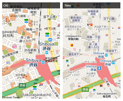
As there are limited street names, landmarks are also an important element for street navigation. The traffic lights, points of interest and prominent local businesses can now be read and found more easily thanks to newly designed icons:
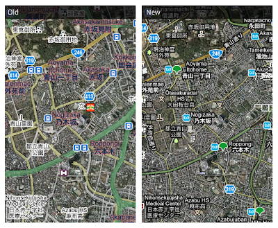 We hope you like the revamped look of Google Maps for Japan, and that it improves your ability to quickly and easily find your way!
Zhou Bailiang, User Experience Designer, Google Maps