We’ve been quite busy this year working on Google Places, Tags, Boost, and our shiny new addition: Hotpot. With so many different products and features now available for local businesses, we wanted to take a step back and explain how the ranking of local listings works when people search on Google and Google Maps.
Product Manager Jeremy Sussman takes us under the hood in this informative video. Below are a few key takeaways, but we encourage you to watch the video, which features helpful examples and visuals.
Local search ranking refers to the placement and order of local information on a Google or Google Maps organic search results page. There are a variety of factors we take into account to provide you with results that match your local search, and three of the primary signals are relevance, prominence and distance. The best way to help potential customers connect with your business is to ensure that your basic company information like its name, address and phone number, are accurate, and then to add rich details like photos, hours of operation and more. You can do this by claiming and verifying your business via Google Places. However, claimed business listings do not receive any special ranking treatment over unclaimed business listings.
Google Tags and Boost are great online advertising solutions for local businesses. Tags make your organic business listings stand out on the Google and Google Maps search results page with a bright yellow marker that highlights specific attributes such as offers, videos or photos. And Boost is an effective complement to your organic Places listing because it quickly and easily creates an ad that can appear alongside the search results - giving your business additional exposure to people searching online. Neither of these advertising products available through your Google Places account affect the organic ranking of your business listing on Google or Google Maps.
Conversely, Hotpot - our new local recommendation engine based on ratings from you and your friends - can definitely affect the ranking of the local businesses you see in your organic search results. If you’re signed in to your Google account and have enabled Hotpot, you’ll get personalized recommendations based on the ratings you and your friends provided - making it easier for you to discover new places you’ll enjoy.
Posted by Brianna Brekke, Senior Strategist, Google Places
At Google we want to make the world's information more accessible and useful to people all over the globe. This includes providing rich local geographic data because a high percentage of search queries have a geographic component. We have often spoken about Google Map Maker, a tool that allows people to help create a map by adding or editing features such as roads, businesses, parks, schools and more.
We are ever grateful to Kenya’s active online cartographers who have helped us build our maps from the ground up. Maps are valuable for users, governments, NGOs, universities and entrepreneurs alike, who can visualise, plan and market the areas and projects that they work on. The mapping session we held recently with 21 volunteers in Korogocho, one of the largest slum neighbourhoods in Nairobi, is one such example of cartographers literally putting their community on the map. We joined forces with Internews and a group of inspiring volunteers from the Korogocho community to build their very own maps.
Ahmed Abdi of Korogocho receives a certificate from Jacqueline Rajuai on completion of the mapping exercise
We only had two and a half days to achieve this task but the group was up to the challenge! After 2 hours of hands-on training on the mapping tools, we embarked on mapping Korogocho and, thanks to the amazing hardworking volunteers from the area, they have now added all sorts of rich information about Korogocho on Google Maps (Map Maker). See below for ‘before’ and ‘after’!
Korogocho before the mapping session
Korogocho after the volunteers mapped the area on Google Map Maker
During this productive mapping exercise, the group mapped social and health infrastructure that is important to their community, including water vendors, public toilets, bio-gas projects, schools, Adopt-a-Light locations and more.
This is the beginning of bigger things that Internews has in store for the area, and we are grateful that they approached us to help them take that first step towards an impressive new map of an important part of Nairobi. We are pleased to continually improve our maps functionality for Africa, and helping to make Africa's information readily available.
Posted by Jackie Rajuai, GIS Specialist, Google Kenya
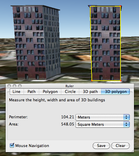
We’re excited to announce a new addition to the Advanced Measurement Tool Suite in Google Earth Pro: you can now measure in 3D!
Pro customers recently ranked Area Measurement as one of the most valuable Google Earth Pro tools, so we wanted to add more to the package. In a continued effort to mirror the real world, allowing you to lift measurements off the ground and extend them in to the 3D realm seemed a natural next step.
We think these tools will be beneficial to our customers as there are limitless applications for their use. 3D Measurements can be used by engineers to plan wind farms, real estate firms to determine skyline views for new high rise buildings, construction companies to measure the materials needed for a retrofitting, architects to calculate the space between buildings, and more.
To measure buildings and distances between buildings, just turn on the 3D Buildings layer and click the Ruler Tool icon in the toolbar. If you’re running Google Earth Pro, you’ll notice two new tabs for measuring in 3D: 3D Path and 3D Polygon.
Here are a few examples of what the new Pro 3D Measurement Tools have to offer.Measure the height or width of a 3D building:
Measure the area of the face of a 3D building:
Measure the distance between a building and a point on the ground or another building:
Today, we launched a new Google Labs product called Google Earth Engine at the International Climate Change Conference in sunny Cancun, Mexico. Google Earth Engine is a new technology platform that puts an unprecedented amount of satellite imagery and data—current and historical—online for the first time. It enables global-scale monitoring and measurement of changes in the earth’s environment. The platform will enable scientists to use our extensive computing infrastructure—the Google “cloud”—to analyze this imagery. Last year, we demonstrated an early prototype. Since then, we have developed the platform, and are excited now to offer scientists around the world access to Earth Engine to implement their applications.
Why is this important? The images of our planet from space contain a wealth of information, ready to be extracted and applied to many societal challenges. Scientific analysis can transform these images from a mere set of pixels into useful information—such as the locations and extent of global forests, detecting how our forests are changing over time, directing resources for disaster response or water resource mapping.
Congo Basin Water Map (detail): Original satellite image (left) and derived water map (right), created using Google Earth Engine [Potapov, P., Hansen,M. - South Dakota State University].
The challenge has been to cope with the massive scale of satellite imagery archives, and the computational resources required for their analysis. As a result, many of these images have never been seen, much less analyzed. Now, scientists will be able to build applications to mine this treasure trove of data on Google Earth Engine, providing several advantages:
Landsat satellite data archives over the last 25 years for most of the developing world available online, ready to be used together with other datasets including MODIS. And we will soon offer a complete global archive of Landsat.
Reduced time to do analyses, using Google’s computing infrastructure. By running analyses across thousands of computers, for example, unthinkable tasks are now possible for the first time.
New features that will make analysis easier, such as tools that pre-process the images to remove clouds and haze.
Collaboration and standardization by creating a common platform for global data analysis.
Google Earth Engine can be used for a wide range of applications—from mapping water resources to ecosystem services to deforestation. It’s part of our broader effort at Google to build a more sustainable future. We’re particularly excited about an initial use of Google Earth Engine to support development of systems to monitor, report and verify (MRV) efforts to stop global deforestation.
Deforestation releases a significant amount of carbon into the atmosphere, accounting for 12-18% of annual greenhouse gas emissions. The world loses 32 million acres of tropical forests every year, an area the size of Greece. The United Nations has proposed a framework known as REDD (Reducing Emissions from Deforestation and Forest Degradation in Developing Countries) that would provide financial incentives to tropical nations to protect their forests. Reaching an agreement on early development of REDD is a key agenda item here in Cancun.
Today, we announced that we are donating 10 million CPU-hours a year over the next two years on the Google Earth Engine platform, to strengthen the capacity of developing world nations to track the state of their forests, in preparation for REDD. For the least developed nations, Google Earth Engine will provide critical access to terabytes of data, a growing set of analytical tools and our high-performance processing capabilities. We believe Google Earth Engine will bring transparency and more certainty to global efforts to stop deforestation.
We’ve been working with several partners to fully develop this platform. In particular, the Gordon and Betty Moore Foundation has been a key strategic and funding partner. The Moore Foundation has also committed over $12 million dollars through its Environmental Conservation Program to projects that support the development of Google Earth Engine. The Moore Foundation’s Environment Program finances practical, enduring solutions to environmental challenges and works to improve the way society uses and manages important terrestrial, freshwater, and coastal marine ecosystems to create working land and seascapes that support resilient and productive ecosystems for current and future generations. They’ve funded the U.S. Geological Survey to scale their infrastructure and accelerate bringing historic Landsat data off tape, and online, through Google Earth Engine.
This animation shows the breadth and depth of the Landsat archive that has been uploaded into Google Earth Engine to date. We are grateful to the USGS for their ongoing technical collaboration.
Support from the Moore Foundation includes funding for several scientists to develop and integrate their desktop software to work online with the data available in Google Earth Engine. Those scientists -- Greg Asner of the Carnegie Institution for Science and Carlos Souza of Imazon -- are also key partners, along with Matt Hansen of the Geographic Information Science Center at South Dakota State University. All are at the cutting edge of forest monitoring in support of climate science.
In collaboration with Matt Hansen and CONAFOR, Mexico’s National Forestry Commission, we’ve produced a forest cover and water map of Mexico. This is the finest-scale forest map produced of Mexico to date. The map required 15,000 hours of computation, but was completed in less than a day on Google Earth Engine, using 1,000 computers over more than 53,000 Landsat scenes (1984-2010). CONAFOR provided National Forest Inventory ground-sampled data to calibrate and validate the algorithm.
A forest cover and water map of Mexico (southern portion, including the Yucatan peninsula), produced in collaboration with scientist Matthew Hansen and CONAFOR.
We hope that Google Earth Engine will be an important tool to help institutions around the world manage forests more wisely. As we fully develop the platform, we hope more scientists will use new Earth Engine API to integrate their applications online—for deforestation, disease mitigation, disaster response, water resource mapping and other beneficial uses. If you’re interested in partnering with us, we want to hear from you—visit our website! We look forward to seeing what’s possible when scientists, governments, NGO’s, universities, and others gain access to data and computing resources to collaborate online to help protect the earth’s environment.
Update on 12/6: Additional information on the Moore Foundation, Google Earth Engine’s Landsat archive, and the Congo Basin Water Map have been added to the post.
Posted by Rebecca Moore, Engineering Manager, Google Earth Engine
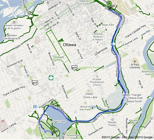
Earlier this year, we added biking directions to Google Maps for the United States, enabling users to more easily find their way when they’d like to take a two-wheeled alternative to walking, driving or public transit. Today we’re expanding biking directions to select regions in Canada: Ottawa, Toronto, Edmonton, Kelowna, Vancouver, Calgary, Winnipeg, Gatineau and Waterloo.
Biking directions on Google Maps enables you to hop on your bike and get from point A to point B, whether you’re planning your daily commute, plotting out your weekend ride, or taking a lunch break. These biking directions easily integrate with all the other Google Maps features, so you can do a local business search to find a great new cafe, read reviews to help you decide if it’s right for you, get biking directions over to it, and pull up Street View to preview your route.
We’ve factored in variables such as hills and bike lanes, and have color-coded roads based on their biking suitability. Dark green indicates a dedicated bike-only trail; lighter green indicates a dedicated bike lane along a road; and the dotted green line indicates roads that do not have bike lanes but tend to be suitable for biking. Just like with driving directions, you can drag the route to customize your trip.
We’ve partnered with a number of Canadian cities, as well as the National Capital Commission, to provide this useful information to cyclists. Ottowa Mayor Larry O’Brien also shared his perspective at the recent Sustainable Mobility Summit.
“The City of Ottawa has always placed a high importance on encouraging residents to use sustainable transportation alternatives like cycling. By having the City's paths, bike lanes and suggested routes available on Google Maps we are providing a convenient, accessible technology for our residents to plan their cycling trips to where they work, live and play.”
City planning agencies can learn more about opportunities to add their data to Google Maps by visiting to maps.google.com/content.
To get started finding biking directions in Canada, visit maps.google.ca/biking. We encourage all riders to help make our biking directions more complete by reporting any missing route information or problems via the “Report a Problem” tool.
From feasting on a turkey dinner to singing carols around the fire, there are certainly plenty of traditions to enjoy during the holiday season. Much to the delight of the child in each of us, the ritual of gift-giving continues today, and I know I still find cheer at the bottom of my stocking every Christmas morning.
Another tradition that brings joy to youngsters everywhere is the one started in 1955 by NORAD, the North American Aerospace Defense Command, which every year counts down to Christmas Eve and tracks Santa’s whereabouts as he delivers presents across the globe. Google similarly started tracking Santa in 2004 and has been partnering with NORAD on this fun project since 2007. Keeping the tradition alive, today marks the kick-off of this year’s countdown at www.noradsanta.org. On the NORAD website, kids can play holiday-themed games (a new one is released each day) and get updates from the North Pole as Santa prepares for his big sleigh ride.
If you haven’t tracked Santa in years past, we hope this is the year you’ll start a new tradition of visiting www.noradsanta.org and following Santa’s journey all around the world. Starting at 2 a.m. EST on December 24, you’ll be able to track him in real-time on Google Maps from your computer or phone as well as on Google Earth with the plug-in by searching for [santa].
So this year, along with my family’s usual tradition of gathering around to hear my mum read “Twas the night before Christmas,” we’ll gather around the computer to see when Santa might be coming to our neighborhood. In honor of the occasion, I wrote a new opening verse:
'Twas the night before Christmas, and Santa was near According to NORAD, he would soon be right here So we hopped into bed and dreamt of new toys And awoke in the morning to much Christmas joy
Happy holidays to all, and to tide you over till Christmas Eve, enjoy this video with highlights from Santa’s journey last year!
Occasionally, we invite distinguished guests to contribute to our blogs and we’re very happy to have Wangari Maathai share her perspective here. In collaboration with Wangari Maathai’s Green Belt Movement and several other partners, the Google Earth Outreach team has created several narrated tours on the topic of climate change in preparation for the UNFCCC’s COP16 Climate Summit 2010 in Cancun, Mexico. Fly underwater to learn about the effects of ocean acidification on sea life with Oceana. Zoom around Mexican mangroves in 3D and learn about the importance of this biodiverse habitat... and what must be done to protect it for future generations. Visit google.com/landing/cop16/climatetours.html to experience these tours. -Ed.
Ask most people what trees mean to them and the first thing that comes to mind is the tree outside their bedroom window or the forest where they played as a child. Trees do occupy a powerful place in our emotions, but the most powerful argument to protect our world’s trees is not based on sentiment. There is a vital interdependency between communities and the trees they rely on for survival. Trees are our watersheds, protectors of the natural environment, and sources of food. Remove the trees from the equation and the community feels the impact.
I came to this realization in the 1970s in Kenya. I was talking to women in my community about their problems: hunger, access to water, poverty, wood fuel. I saw a link between their needs and the condition of the land and thought, “Why not plant trees to address these issues?” Trees hold the soil to the ground so that we can grow food in it, they protect watersheds and facilitate harvesting of rain water, fruits trees supplement food and trees give us domestic energy and wood with which to build our shelters. So while still working at the University of Nairobi, I established a tree nursery in my backyard, planted seven trees at a public park and founded the Green Belt Movement. The organization works to empower communities, to build their capacity to restore Africa's forests and put an end to the problems that deforestation and other forms of environmental degradation cause. As a result of this idea, more than 40 million trees have been planted to restore the environment and improve the lives of the people who are linked to the land.
When we were offered a unique opportunity to partner with the Google Earth Outreach team on a project using new Google Earth technology to visualize trees in 3D, we were thrilled. For accuracy and integrity we worked very closely with Google, advising them on the modeling of unique African trees like the broad-leaved Croton, the Nile tulip tree and the East African Cordia. These tree models illustrate the biodiversity in our tree planting sites, especially in the forests, and how we carefully select trees that are indigenous and sustainable to the natural surroundings.
Broad-leaved Croton, the Nile tulip tree and the East African Cordia (from left to right)
We then used data from real planting locations to “plant” the tree models in Google Earth and create 3D visualizations. Now, for the first time in Google Earth, people from all over the world will be able to virtually visit these planting sites, explore the 3D trees and connect with the work that we are doing.
Green Belt Movement planting site in 3D on Google Earth
Tree planting is a simple activity with tangible results, and anyone can participate. It helps people come together to address common problems and work collectively towards community improvement and sustainability. I hope that seeing our beautiful tree planting sites in 3D on Google Earth will be a source of inspiration for people to engage, plant trees and organize planting activities in their own communities. Taking charge of our lives and the environment around us can help ensure a lasting legacy and healthy future for our children.