Monday, December 13, 2010

Introducing the Google Latitude app for iPhone

[Cross-posted from the Google Mobile Blog]

“Where are you?”


Starting today, you’ll never again have to answer (or ask) that question when you’re on the go with your iPhone. With the new Google Latitude app for iPhone, you can see where your friends are and now, continuously share where you are – even in the background once you’ve closed the app.


Since launching last year, Latitude’s focus has always been on one goal: make it simple to stay in touch with friends and family by sharing where you are with each other. Simple setup. Simple sharing without fumbling for your phone. Now, you can use Latitude on your iPhone just like the more than 9 million people actively using it from Android, BlackBerry, Symbian, and Windows Mobile smartphones. Use the app to:
  • See where your friends are
  • Share your location continuously with whomever you choose
  • Contact friends by phone, text message, or email
  • Control your location and privacy


Watch the Latitude app for iPhone in action

You still get simple control over your privacy. Remember, Latitude is 100% opt-in. You must install the app and add friends (or accept requests) to start sharing your location. You can turn off background updating if you’d like and control the same privacy settings: share only city-level location, hide your location, or sign out of Latitude at any time. Learn more in the privacy tips video.

Though we released Latitude as a web application before the iPhone supported third party background applications, today’s Latitude app was built from the ground up using iOS 4’s new multitasking capability to support background updating. You’ll need iOS 4 and above on an iPhone 3GS or iPhone 4 to use the app.

Download Google Latitude now from the App Store in over 15 languages and 45 countries. It will be appearing in the App Store over the next day, but you can also find it directly now. Learn more in the Help Center or ask questions in the Help Forum.


Directions, the way you want them


We recently released advanced options for getting public transit directions on Google Maps, helping you customize your route based on your personal preferences.

We work hard to provide the right results to get from A to B, but sometimes riders have their own preferences. For example, you might not mind a longer journey if it means fewer transfers; or you may prefer traveling by bus or train, rather than subway, to have views of your route. You can now specify these preferences and alter your route results by clicking the “Show options” link below your destination:


We hope that this new feature makes it easier for you to find your way! To get started, please visit maps.google.com/transit.

Posted by Noam Ben-Haim, Product Manager

How to find directions online (and 50 other things you might want to teach your parents)


Everything really is bigger in Texas, as my parents found out when they moved to Houston from Kansas in early November. Since moving, my mom - who openly admits that navigation isn’t her strongest suit - was getting lost quite often as she settled into her new hometown. She found herself spending just as much time trying to find the grocery store as doing the actual shopping. So when I headed home for Thanksgiving, I gave her a quick lesson on how easy it is to find directions online using Google Maps.

With millions of people travelling across county and state lines for the holidays, my mom probably isn’t the only one who could use a quick tutorial on how to get simple, easy to understand, and accurate turn-by-turn directions.

That’s why a bunch of Googlers got together to create a website - TeachParentsTech.org - that enables kids to send basic how-to videos to mom, dad, or even grandma. Check out this video in which I show just how easy it is to get from Point A to Point B with the help of Google Maps.


To see more videos, or to send someone a tech support care package of your own, make sure to visit TeachParentsTech.org.

Posted by Preston Hershorn, Product Marketing Manager

Thursday, December 9, 2010

Trailblazing in Portland

[Cross-posted from the Hotpot Community Blog]

When we announced the availability of Hotpot last month, we knew from the beginning we were going to take a different approach to marketing the product and engaging with our users, both businesses and consumers.

To that end, we’re excited today to start testing this new approach by launching our first local marketing campaign in Portland, Oregon. Portland is a tech savvy, forward-thinking city with a history of innovation and some of the best coffee houses, microbreweries and parks in the country. Whether you know it as The City of Roses, Stumptown, P-Town, Rip City or just PDX, Portland’s thriving local business community and strong heritage of being a trailblazer made it a great choice for us to try something new.

So starting today and over the course of the next few months, we’ll be out and about in Portland. Here’s a taste of what’s in store:

Business Kits and Window Decals


Every day millions of people search on Google.com to find local businesses, and we want to make it seamless for standout businesses to get discovered online. To achieve this, we’ll be working directly with some of Portland’s top businesses to educate them about Google Places for business and all its benefits. In addition, to help these businesses spread the word, we’re providing owners with special Google Places Business Kits. These kits are a multi-flavored sampler of marketing materials that can help businesses get even more exposure, get them rated and reviewed online, and get more customers through their door. We’re already distributing these to some of Portland’s top businesses, but any business in Portland who has claimed their Place page can request a box.
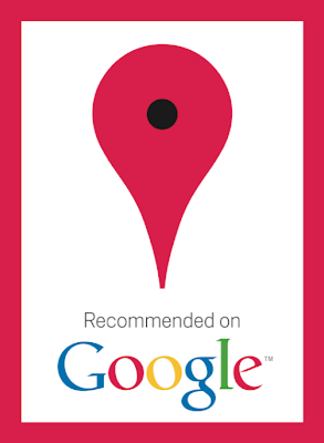

A central part of the kit is the bright red “Recommended on Google” window sticker. This is not your ordinary sticker. Unlike others, this is an interactive sticker that has Near Field Communications (NFC) technology built right in, allowing people with cutting edge phones like the Nexus S to simply touch their phones to the sticker to find out more information about the business. Suddenly stickers are cool again!

Community Events


Sure, Hotpot’s about sharing recommendations with friends online. But we thought it’d be fun to take things offline. To kick things off, we’re partnering with Portland’s beloved Voodoo Doughnut. Because we at Google are such big fans of their tasty treats, we wanted to spread the love — so if you like doughnuts and coffee, be sure to stop by both locations starting this Saturday at 10am for a special treat.

Hotpot Jackpot


We’re also launching our second Hotpot Jackpot competition to encourage Portlanders to start rating the places they know and share them with friends and family. Everyone over the age of 18 who lives within a 50-mile radius of Portland can participate, and the top five raters at the end of the competition will win dinner for 10 at any restaurant in Portland, courtesy of Google. To kick things off, all of the fans at tonight’s Trail Blazers vs. Magic game will receive t-shirts announcing the competition and supporting the Blazers.

This is just the beginning and we’ll be doing a lot more in the upcoming months. For the latest and greatest of what we’re up to in Portland (and elsewhere), keep an eye out by staying up to date via the Hotpot Blog, and by following us on Twitter and liking us on Facebook.

Posted by Bernardo Hernandez, Director of Emerging Marketing

Wednesday, December 8, 2010

Street View in Romania


Bram Stoker’s world famous novel Dracula was believed to have been inspired by fifteenth century Wallachian Prince, Vlad Dracul from Romania (better known to many as Vlad the Impaler). The legend of the vampire is still deeply rooted in Transylvanian culture today, and tourists from across the world come to explore the history and mystery of the many beautiful castles that can be found here.

But of course those aren’t all the sights Romania has to offer, and now you can see for yourself, because today we’re making 360-degree Street View imagery available in Romania for several cities and roads.

From your virtual vantage point, you can now take a look over the bridge onto Lacul Vidraru (Vidraru Lake). This is the starting point of the most beautiful road in Romania, the Transfăgărășan mountain pass, which at its highest point reaches 2,034 meters above sea level:


Or check out the summer residence of Romanian Kings, Castelul Peleș (Peleș Castle):


It’s not just Paris that has an Arc de Triomphe. You can whizz round the Romanian
Arcul de Triumf in the capital Bucharest:


And here’s our parliamentary palace, Palatul Parlamentului (Parliament Palace):


There’s heaps to explore but I’ll leave you with one final tip, and that’s to visit
Vatra Ardealului, my favorite cofee shop in Brasov, which you can see below:


Welcome to Romania and enjoy your virtual exploration!

Posted by Octavian Iercan, Operations Lead, Street View Europe

Monday, December 6, 2010

Cricket Season Has Begun!


Summer has arrived in the southern hemisphere, which in Australia, means cricket!

The Ashes,” a tournament series played between England and Australia, recently began a couple weeks ago so the competition is underway. It’s said to be international cricket's most celebrated rivalry, dating back to 1882.

The series is played biennially, alternating between the United Kingdom and Australia. Since cricket is a summer sport, and the venues are located in opposite hemispheres, the break between series alternates between 18 and 30 months.


In Australia, where the tournament is being played this year, the “grounds” (stadiums) used are "The Gabba" in Brisbane, the Adelaide Oval, the WACA in Perth, the Melbourne Cricket Ground (MCG) and the Sydney Cricket Ground (SCG), in that order.

A view of the Sydney Cricket Ground in Google Earth

So whether you’re a cricket newbie like me, or a veteran “cricketer,” we hope that you’ll explore all of these grounds in Google Earth, or just enjoy our video tour, today!

Posted by Bruce Polderman, Product Manager

Friday, December 3, 2010

Rediscover Historical Imagery in Google Earth 6


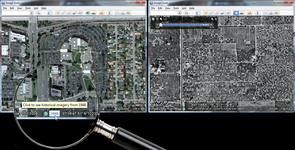
Historical imagery is one of the most powerful features of Google Earth, enabling you to go back in time and browse the visual historical record of our planet - from the evolution and rise of developing communities to the destruction caused by hurricanes, earthquakes and fires. With Google Earth 6, we’ve made it easier than ever to discover historical imagery. In addition to streamlining the timeline interface, we’ve added a date button to the status bar to notify you of past imagery that you might be interested in exploring. So now, when you zoom in on a location in our latest version of Google Earth, the button will appear highlighting specific years. Clicking it enables historical imagery and takes you back to the year you selected. For instance, when I zoom in on the headquarters of a certain company with a fruit namesake nestled in the heart of Silicon Valley, Google Earth suggests imagery from 1948. Clicking the date button reveals the fruit tree orchards that used to inhabit that very location. I wonder if they were apple trees.

Google Earth 6 suggests historical imagery to explore, e.g. of Silicon Valley in 1948

In the almost two years that historical imagery has been available, we have captured several moments of cultural significance, such as the inauguration of the first African American President of the United States, the devastation of Hurricane Katrina, and the transformation of South Africa in preparation for the 2010 FIFA World Cup.

Washington D.C., January 20, 2009. Can you spot where the jumbotrons were installed?

But the feature is more than just what historians deem significant. We built the historical imagery database to enable anyone to see and tell their own personal history. A great example comes from fellow historical imagery engineer Reuel Nash:

In 1979, my wife and I spent the first night of our marriage in a hotel at Dallas/Fort Worth International Airport. It was still there in 1995, which you can see in Google Earth. The hotel and the surrounding area has since been replaced by Terminal D. You can see the terminal construction (and destruction of the hotel) literally from the ground up using historical imagery.

The construction of Terminal D at Dallas/Fort Worth International Airport

We have a vast amount of data in our historical imagery archive, so you’ll be able to tell your own personal stories by browsing those places that are special to you. In fact, we have more square miles of high resolution imagery in our historical imagery archive than in our default view. In the coming years, we look forward to expanding this imagery collection even further. Visit the Historical Imagery Showcase to watch video tours of cities with imagery dating as far back as 1940.


Posted by Chris Co, Google Earth Software Engineer