Monday, July 11, 2011

Let Historypin be your guide


Editor’s Note: Today's guest author is Nick Stanhope, co-founder and executive director of an awesome and inspiring website out of the UK called Historypin. We collaborated with the site for its launch as a beta last year, and Nick is writing a guest post to announce today's official launch of Historypin with a new mobile app and expanded global availability. His team’s labor of love illustrates the amazing ways individuals and organizations can use Google Maps and Street View to share new (or in this case, old) views of the world around us.

A few years ago, just before she passed away, my Gran and I spent a lot of time together looking through some of her old photos and family videos, sharing stories and learning a bit more about each other’s lives. This picture of my Gran and Great Auntie Jenny, working as land girls in the summer of 1943, was one of my favourites.

Everyone can identify with this sense of wistfulness and nostalgia that memories often evoke. Sometimes it’s triggered by talking to a grandparent about what they did at your age, by learning more about the guy in the photo who looks like a Victorian version of your Uncle Phil, or by chatting with an older neighbour about how different Main Street looked fifty years ago.

This is what Historypin is all about: conversations between different generations and neighbours, time spent around sights and sounds of the past, stories remembered and shared and comparisons made between then and now. And today, we’re thrilled to announce its graduation from last year’s beta phase with worldwide availability, the addition of a new mobile app, and a bunch of other exciting new developments.

Historypin is a website and smartphone app that uses Google technology in new and creative ways. You can explore old photos, videos and audio clips that have been “pinned” onto Google Maps (which you can search not only by location but also by date), compare these glimpses of the past with how they look in today by seeing them overlaid onto Street View, immerse yourself in local history using the Android app, journey through Tours and Collections of featured content and, best of all, “pin” your own history as photos, videos, audio clips and stories to the site.

And by continuing to work closely with Google, we’re excited about the improvements to come as well. Later this year, we’ll launch additional new features like embed tools that enable you to put Historypin on your own site, Historypin channels that will allow you to create your own distinct experiences, and pinning games that invite the community to pin content that we and our partners know little about.

But, really, it’s not about the tech. It’s about those conversations - little ones, across families and streets, and big ones, involving millions of citizen historians. Through all of these conversations, we can create a place to explore history in amazing ways and help families and neighbourhoods come together around what we all share: history.


Friday, July 8, 2011

Street View comes to glamorous Monaco


Last week the spotlight was on Monaco for the royal wedding between Albert II, Prince of Monaco, and Charlene Wittstock. Today we are excited to announce that we are bringing Street View in Google Maps to the glamorous principality.

Monaco may be the second smallest country in the world, only the Vatican City is smaller, but it has many interesting sites and roads.

You can now explore the streets made famous by the annual Formula One Monaco Grand Prix, one of the most prestigious automobile races in the world. The circuit snakes around the principality and is known for its tight corners and the legendary tunnel.


View Larger Map


Cathédrale de Monaco

Monaco’s elegant hotels and casinos are also now available on Street View, along with its stunning views of the French Rivieria and the Mediterranean Sea.

Port de Cap d'Ail, Monaco

We hope you enjoy this virtual trip to Monaco, the 30th country where immersive, 360-degree street-level views are now available on Google Maps. We’re thrilled to share the new imagery with you on the heels of last week’s biggest Street View update ever, and look forward to bringing many more locales to Street View for you to explore.

Thursday, July 7, 2011

South Sudanese sing and map their way to independence


On July 9, South Sudan will officially be independent, becoming Africa’s 54th state.

In anticipation of this significant development, the World Bank, UNOSAT, RCMRD, Satellite Sentinel Project and Google organized a South Sudan Community Mapping event in Nairobi on June 30. This was the second in a series of mapping events intended to encourage local people to create accurate and detailed maps of South Sudan, to help them navigate their path to independence. There were over 100 attendees in the room, mostly Sudanese -- university students, humanitarian workers, journalists, developers, donors, citizens -- coming from Nairobi and its surroundings, but also as far as Juba, the capital of South Sudan.

The lives of the South Sudanese are anchored to their history and land. The event started with the sharing of prayers, stories and songs, allowing each of us to visualize the rivers, sheep, roads, and people. Drawn from these songs, the mapping of South Sudan with Google Map Maker began. I was excited to see schools, roads, rivers, historical monuments, and cemeteries being mapped over cities such as Aweil, Boma, Bor, Malakal, Rumbek, Tonga, Torit, and more.

Community Mapping Event in Nairobi on June 30, 2011

Many were interested in health resource mapping which can dramatically impact the lives of their new countrymen. Every year in South Sudan about one in every seven children dies before the age of five; the maternity mortality rate is one of the highest in the world, and only 30% of the population has access to health care. For Charles Mona, Director GIS, Remote Sensing & Cartography of the South Sudan Government, quality health resource maps would be great tools for improved health care planning, resource allocation, advocacy, and also increased access to health services for the local population. This is only one example of how accurate maps can help various organizations provide better services to the the South Sudanese.

Happy independence day to the South Sudanese! Together, let’s continue mapping, and stay connected via our Sudan-specific email discussions. The next Community Mapping event will be in Juba, so stay tuned for more details.

Expanded 3D Buildings coverage


(Cross-posted on the Official SketchUp Blog)

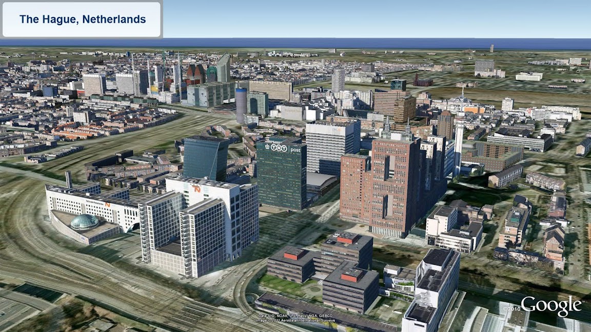
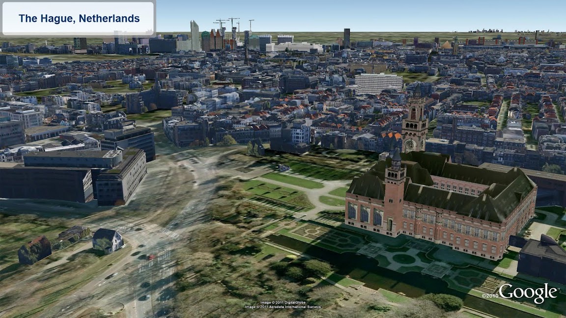
Looking for new 3D cities to explore in far off places? Well, you’re in luck! We’ve been hard at work expanding our 3D coverage by adding ten of thousands of 3D buildings to these cities:
  • Berkeley, California USA
  • Cologne, Germany
  • The Hague, Netherlands
See the new buildings for yourself with the “3D Buildings” layer in Google Earth or by using Google Maps with Earth view.


Happy touring!

“Download map area” added to Labs in Google Maps for Android

(Cross-posted on the Official Google Blog)

One way we bring you new product features is through Google Labs—a collection of fun, experimental features you can turn on if you’re interested in the functionality. In fact, Google Maps itself started as a lab. In addition to our desktop Maps Labs, Google Maps for Android has a few tricks you can try out right from your phone. We’d like to introduce you to one new experimental feature, “Download map area,” but also remind you of two other ones we already have: “Scale bar” and “Measure.”

Download map area
When you’re visiting an unfamiliar location, Google Maps for mobile is great for getting an idea of how close you are to your destination, where streets and landmarks are in relation to each other, or just for getting “un-lost.” But what if you don’t have a data signal, or you’re abroad and don’t have a data plan? We say that if you use Google Maps for mobile, you’ll never need to carry a paper map again. The “Download map area” lab in Google Maps 5.7 for Android is a step in making that statement true even when you’re offline.

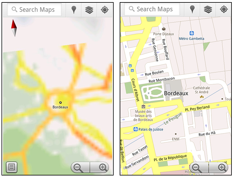
Let’s say later you’re visiting Bordeaux during a trip to France. If you were to open Google Maps for mobile and zoom into Bordeaux without data coverage or wifi, you’d see the image on the left:

Left: Bordeaux with no data or wifi. Right: Bordeaux with downloaded map area

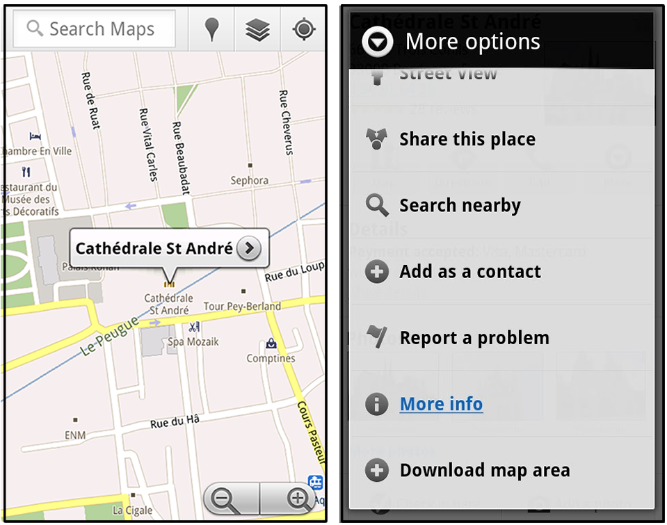
That’s not particularly useful when you’re trying to find out how close you are to the Cathedrale St. Andre. But a little advance planning and “Download map area” can help. Before you take your trip, while you still have access to WiFi or data coverage, you can open up any Places page in the world, click “More” to get the Place page menu, and download Google’s maps for a 10-mile radius.

Left: Tap a landmark to enter its Place page Right: Place page “more options” menu

The download can take as little as a minute or two. This download stores only the base map tiles and the landmarks on the map, so you still need a data connection to see satellite view and 3D buildings, search for Places and get directions. But we hope the level of detail available will help you find your way!

Left: Status screen for download. Right: Coverage of downloaded map area

All your downloaded map areas can be managed in your Google Maps cache settings so you can delete maps you no longer need or if you want to free up storage. After 30 days, all downloaded map areas will be removed from your cache; they can be re-downloaded any time.

Scale bar
Google Maps has approximately 20 different zoom levels that range from a 2,000 mile scale to a 20 foot scale. With finger gestures making it really quick and easy to zoom in and out, sometimes it’s not always clear what zoom level you’re at. What might be just a few streets away can be quite a long walk depending on the scale. To help with this, you can turn on a scale bar, which updates based on your zoom level.

Scale bar in the lower left

Measure
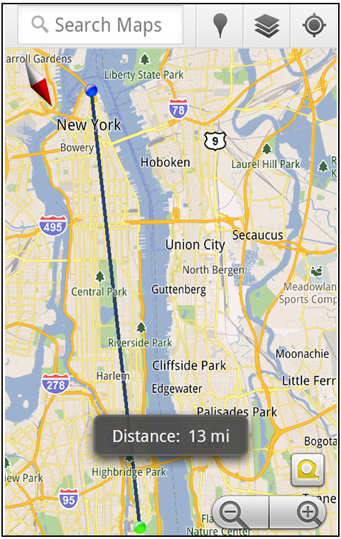
If you ever need to know the distance between San Francisco and New York (about 2602 miles) or between any other two points on the map, the “Measure” lab can help you out. Once it’s enabled, you’ll notice a tape measure icon just above the zoom buttons. After clicking that icon, you’ll be prompted to tap two points on the map and Google Maps will calculate the straight distance between those points (this direct distance is “as the crow flies”).

Example of the “Measure” Labs feature

To access Labs on your phone, press your phone’s menu button once in Google Maps, choose “More” and select Labs. On a tablet, click the menu button in the upper-right corner of Maps. The “Download map area” lab requires Android 2.1+ and the latest version of Google Maps. We look forward to bringing you more experimental features soon and hope you enjoy trying out Labs in Google Maps for Android.

Wednesday, July 6, 2011

Google Maps 5.7 for Android introduces Transit Navigation (Beta) and more


(Cross-posted on the Official Google Blog)

Today we’re releasing Google Maps 5.7 for Android. From Bangkok to Baltimore, we’ve added Transit Navigation (Beta), updated access to directions, better suggested search results, and a photo viewer to Place pages—all of which can help you whether you’re traveling to an unfamiliar part of town or visiting a city across the world.

Transit Navigation (Beta)
Google Maps Navigation (Beta) currently provides over 12 billion miles of GPS-guided driving and walking directions per year. Now, GPS turn-by-turn (or in this case, stop-by-stop) navigation is available for public transit directions in 400+ cities around the globe with Transit Navigation.


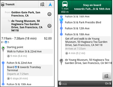
Transit Navigation uses GPS to determine your current location along your route and alerts you when it’s time to get off or make a transfer. This is particularly helpful if you’re in a city where you don’t speak the language and can’t read the route maps or understand the announcements. After starting your trip with Transit Navigation, you can open another application or put your phone away entirely and Google Maps will still display an alert in your notification bar and vibrate your phone when your stop is coming up.

Left: Transit directions without Navigation. Right: with Navigation


Navigation alerts appear even if you switch to another app

Now you can spend more time enjoying the sights out the window and less time worrying about how many stops are left, where you are along the route or whether you missed your stop. Since Transit Navigation relies on GPS signals, we recommend using this feature for above-ground transit.

Updated Directions
Now that we’ve improved our directions services, we wanted them to be incredibly easy to pull up on your screen. If you select the driving or walking icon and your route is supported by Google Maps Navigation, the Navigation icon will automatically appear so you can get access to step-by-step directions in one click. Note: this change is currently only in place for driving and walking and does not appear for public transit.

One-click access to Navigation from directions

We’ve also streamlined how you access directions from within a Place page. Before, clicking directions in a Place page would bring up options for “Driving Navigation,” “Walking Navigation” and “Directions.” Now, you’ll be taken straight to the map and see the new directions box shown above.

Improved Search Suggest
We’ve made two changes to search suggestions that improve their quality and speed. First, we’ve added category icons, so instead of all search suggestions displaying the same icon, the icon next to the listing will reflect the type of result. You’ll see a pin for a Google Places listing, a star for a starred Place or location, a clock for a previously used search term, a person for contacts and a magnifying glass for “anything else.”

Two examples of search suggest with new icons

Also, any place you got directions to or called directly from its Places page will be included as a suggestion for a relevant search. For example, if you recently received directions to the U.S. Post Office on Wilshire Boulevard, afterward, when you begin a search with [p] or [bou], that U.S. Post Office would appear as a search suggestion.

Photo viewer for Place pages
Since we released business photos for Place pages last October, millions of photos have been added to Place pages around the world. To enable you to view these photos on the run, a slick new photo viewer has been added so you can browse photos while deciding where to go.

Left: Business photos in Place pages. Right: New photo viewer

To start using Google Maps 5.7 for Android, download the update here. This update requires an Android OS 2.1+ device and works anywhere Google Maps is currently available. Learn more at our help center and have fun exploring, whether it be by car, transit, bike or foot.

Tuesday, July 5, 2011

Geo Developers at Google I/O 2011


If last year’s Google I/O was about the maturation of many of the Geo APIs, this year’s was more about their sophistication, both in the designs discussed and the applications on display. Like the sun standing still at the solstice, let’s take a moment to reflect on recent events and look ahead to the coming season.

Several new features made their debut at I/O this year. The much-anticipated Places API took the stage, as did its companion the Places Autocomplete API. Dynamic Styling was introduced for Fusion Tables layers in the Maps API, allowing layer styling to be defined by the API application via Javascript. Finally, some extremely helpful open source Javascript libraries were introduced to make Maps API development even easier.

Joining us on stage were several developers who came to share their expertise. Justin O'Beirne of 41Latitude talked about map usability and design in the “Designing Maps Applications for Usability” session. The Guardian UK’s Simon Rogers joined us to talk about how the Guardian is using Fusion Tables to visualize the data they collect in “Managing and Visualizing Your Location Based Data.” Yoni Samlan from SCVNGR also came to discuss developing with the Places API in “Location-based App Development.”

In addition to the sessions led by the Geo team, the developer sandbox featured eight Geo API partners who engaged directly with I/O attendees. Joining us in the sandbox were HistoryPin, Icon Fitness, Ubisense, The Wall Street Journal, Footprint Feed, The Bay Citizen, Arc2Earth, and Travel Game. The apps on display ranged from location-based gaming using the Latitude API to tools for citizen journalists to map public data using Fusion Tables. You can learn more about two of our sandbox partners in these video case studies:
  • The Bay Citizen (video) - The Bay Citizen explains the benefits of the Fusion Tables layer with Google Maps API to build infographics for their online newspaper. The Bike Accident Tracker visualizes the prevalence of bike accidents across San Francisco.
  • Historypin (video) - HistoryPin lets users upload historical photos, geotag them on a Google Maps, and overlay the old imagery on top of new Street View imagery, enabling users to see what their cities looked like at different points in time.


Geo APIs Summer Learning Series (apologies to the Southern Hemisphere)

But at the heart of Google I/O are the sessions themselves. This year, speakers from the Maps, Earth, and Fusion Tables teams covered a wide range of topics, from ensuring high performance and usability across all browsers to visualizing huge data sets with Fusion Tables. The amount of material covered was enormous...but we want to expand upon it.

To that end, we’re pleased to announce the "Geo APIs Summer Learning Series” on the Geo Developers Blog. Over the coming weeks, each talk will be getting its own blog post from the session speaker, pulling in what was discussed at I/O and then digging deeper into the technical content. Here is how the series will unfold:

Week of July 6th
Connecting People and Places
Location Based App Development using Google APIs
Secrets and Surprises of the Google Geo APIs

Week of July 11th
Managing and visualizing your location based data with Fusion Tables
Designing Maps Applications for Usability on Mobile and Desktop

Week of July 18th
High Performance KML for Maps and Earth
Speedy Maps

Week of July 25th
Map your business, inside and out
GIS with Google Earth and Google Maps

If you’d like a head start, videos of all the I/O sessions are linked above. Be sure to visit the Geo Developers Blog throughout July for even more great content from the Maps, Earth, and Fusion Tables teams.