Showing posts with label Google Maps. Show all posts

Thursday, September 1, 2011

New 45° imagery available for 24 cities

This month’s update to 45° imagery in Google Maps includes coverage of more U.S. and international cities, particularly in Spain.


For example, Girona, a city in the autonomous region of Catalonia and close to the French border, has many historical monuments in the city center. One of these monuments, Santa Maria Cathedral, features several different architectural styles because it was erected during a period of more than 400 years, beginning in the 14th century.


View Larger Map


Another new city with 45° imagery is the city of Merida, the capital of the autonomous region of Extremadura. The city is a Roman foundation for military veterans and is full of monuments around 2,000 years old such as two Roman bridges, an amphitheater, the Circus Maximus (a horse race track), a Roman theatre, temples and more.


View Larger Map


In the U.S. we expanded coverage to cities such as Knoxville, Little Rock, Reno, Spokane, and Tallahassee to name a few. Little Rock, the capital of Arkansas, features a statehouse similar to the Capitol in Washington. The city was founded in 1812 by William Lewis but archaeological research indicates the area was settled by Native Americans much earlier.


View Larger Map


Here is a complete list of updated cities:


Augusta, GA; Badajoz, Spain; Boise, ID; Boston, MA; Fairfield, CA; Girona, Spain; Knoxville, TN; Lausanne, Switzerland; Little Rock, AR; Lodi, CA; Merida, Spain; Modesto, CA; Montgomery, AL; Murrieta Hot Springs, CA; Provo, UT; Reno, NV; Salem, OR; Sebastopol, CA; Spokane, WA; Tallahassee, FL; Vacaville , CA; Vallejo, CA; Victorville, CA; Wichita, KS; Yucaipa, CA;


*Updated the post to reflect the fact that Catalonia is an autonomous region


Monday, August 29, 2011

+1 your favorite custom maps


Today, we’ve launched the +1 button for custom maps in Google Maps. By clicking the +1 button you can tell other viewers that a particular map is helpful. It’s also a way to thank the specific map author for creating a useful custom map. For instance, say your friend created an awesome map of Hawaii Hikes and Surfing. Now you can let them know it was handy by clicking the +1 button. You can find the +1 button underneath the map description on public maps when you‘re signed into to your Google account.


New! +1 custom maps


You can keep track of your +1’d maps by going to your Google+ profile, and clicking the +1 tab. Your +1's are always public, but your +1's tab doesn't have to be. You can choose to show this tab to the world, or simply use it to manage your record of things you love around the web. Currently, the +1 button only shows up on maps.google.com and not on embedded views of maps.


Maps you +1 show up on your profile


But don’t just +1 other peoples’ maps, get +1’d yourself! Create your own custom maps and share your must-stop-spots for travel destinations or your own neighborhood. Custom maps enable you to highlight sites, restaurants, shops, routes and more for anyone you choose to send your map to. To get the link for your map, open the map and then click the link button in the upper right. Copy and paste this link into an email or IM or post it to your Google+ profile so others can find it.


Send out links to your custom map


Create Maps. Share Maps. +1 Maps.


Friday, August 26, 2011

Mapping Hurricane Irene


With Hurricane Irene headed towards the East Coast of the United States, the Google Crisis Response team has assembled a collection of map data to help you keep track of the storm. From this map, you’re able to get most recent hurricane-related information from such sources as NOAA’s National Hurricane Center and FEMA.


To help explore this information, we’ve created the Google Crisis Map, a map viewer with the latest available geographic information. Here’s some more information about the map’s content and features:

  • Google Crisis Map always shows the latest, valuable information we've been able to uncover on the most current situation
  • You can zoom and pan the map using the on-screen controls, and turn layers of information on or off just by clicking
  • You can find out more about the map layers by visiting the linked websites of the content owners
  • The site is optimized for mobile, so you can look at the map on a mobile phone as well as your desktop
  • You can also share the map, or embed it on your website or blog by clicking share to find the URL and HTML code


Hurricane Irene map viewer


To provide feedback or comments on the map, or if you’re aware of map layers or other datasets that you would like to see included on our maps, please submit them for our consideration at google.org/crisismap. We’ll continue to update the Crisis Response website with other valuable resources on Hurricane Irene and relevant preparedness tips.


To view the projected and historical path of Hurricane Irene in Google Earth you can visit the Google Earth Gallery or download the KML file.


We hope these tools help keep you and organizations better informed about diaster preparedness.


Thursday, August 25, 2011

Search Google Maps out loud


Tired of typing? Without using your keyboard, you can now talk into Google Maps to look for places and get directions. If you’re using a Chrome web browser in the U.S. (English only for now), simply click the microphone icon and speak into your computer.


Click the mic and ask for a place to get started


Using voice search can make it easier to find hard-to-spell places (like Poughkeepsie or Liechtenstein) or simply get directions without typing (for example, say “Directions from Los Angeles to San Francisco”). Or if you’re interested in exploring the world through the Earth layer (using the plugin), you can just say where you want to go and fly over to that location directly within your browser!


Fly to places just by saying your query


If you didn’t already know, you can also use voice commands on Google.com, your Android device or on the Google app for your iPhone. Take a look at this video for desktop voice search to find out how voice actions can make your life easier.


Have fun talking out your searches on Maps!


Wednesday, August 24, 2011

Panoramio Groups: Join a photo community to match your interests


Cross-posted on the Panoramio and Official Google blogs.


I'm from Barcelona, and once a year I go to Costa Brava on the Mediterranean with my friends to enjoy good food and nice weather. I always carry my camera with me to capture the beach when the light is just right, take photos of my favorite meals or document my latest hike. When I get home, I upload my photos to Panoramio and position them on the map. Pictures uploaded to Panoramio can be featured in the “Photos” layer of Google Earth and Google Maps, which means that I can share my travel experiences with others and, in return, explore places around the world through the eyes of other photographers.


Starting today, you can share your passions through photographs more collaboratively with Panoramio Groups. This new feature lets you create a sub-community within Panoramio around a topic you’re passionate about, so you can easily engage with like-minded photographers and hobbyists.


Panoramio is an online community of people that share and explore photos of the world.


For example, in my trips around the world, I always take the time to enjoy the local cuisine, like Costa Brava’s arròs negre. So I created a group called “Food,” to give others a "taste" of that region and get a glimpse of what fellow foodies are feasting on. My fellow group members—and by all means I hope you’ll become one of them!—can add their own photos, browse others' and get culinary and travel inspiration.


Panoramio Groups allow members to share photos and start discussions on a given topic.


To share your own interests and passions through photos, hop over to Panoramio and create your own group or join an existing one from the Groups Directory. You can show off your photos of your favorite restaurant, the most beautiful sunset you’ve seen, the latest lighthouse you’ve visited, or the cutest dog from each continent. Whatever it is, try starting a discussion about your favorite topics and share what matters to you with others.


Visit www.panoramio.com/groups to get started. We hope you enjoy this new addition to Panoramio—let us know what you think in the Panoramio Forum!

Tuesday, August 23, 2011

Just a Short URL away


A little over a year ago, we began testing a feature in Google Maps that automatically generated a Short URL (aka URL Shortner) to link to any page on Google Maps. This quickly became one of our most popular experiments, and today we’re excited to announce that we have graduated the Short URL into an official feature of Google Maps.


Starting today, when obtaining a link to a Google Map using the 'Link' button on the upper right-hand corner of the page, you now have the option of obtaining a convenient, shortened link by clicking on the 'Short URL' check box. Shortened URLs can make it easier to coordinate events and share maps with your friends.


Click on the link button to create a Short URL for a location


All shortened URLs generated by Google Maps take advantage of Google’s recently announced g.co shortening service. We only use g.co to send you to Google web pages, and only Google Maps can generate a g.co/maps URL. This means that you can visit a a g.co/maps shortcut with confidence, and always know you will end up on a Google Maps page.


Monday, August 22, 2011

Introducing GTFS-realtime to exchange realtime transit updates

(Cross-posted from the Google Code Blog)


In June, we launched Live Transit Updates, a feature that adds realtime public transport information to Google Maps and Google Maps for mobile. This feature is powered by the GTFS-realtime feed format. Today we’re making the specification of this format public on Google Code. GTFS-realtime allows public transport agencies to provide realtime updates about their fleets. If you’re developing a trip planner or similar application, you can process these feeds and keep your users up-to-date with realtime information.


GTFS-realtime is an extension to GTFS, the General Transit Feed Specification, published by Google in 2006. Nowadays, GTFS is a very commonly used feed format that public transport agencies use to (publicly) provide their transport information. As opposed to GTFS feeds, GTFS-realtime feeds contain very dynamic information. This means that they have to be updated frequently and applications that use them have to fetch them frequently as well. This requires a significant infrastructure from the transport agency’s side, but it results in a continuously updated description of the current situation.


The specification currently includes three types of realtime updates: Trip Updates, Service Alerts and Vehicle Position updates. Each type of update has to be provided in a separate feed, and can be used independently.


Trip Updates are a way to present changes in the timetable. When a trip is delayed, canceled, added or re-routed, a Trip Update can be used to provide this information in realtime. Service Alerts can be used to notify passengers about special circumstances in the public transport network. In a Vehicle Position update, an agency provides the current location of an individual vehicle.


To encode realtime updates, Protocol Buffers are used. Protocol Buffer data structures can be processed very efficiently, resulting in low processing times compared to other popular data encapsulation standards. Because Protocol Buffers are compressed, they also use communication bandwidth efficiently. Protocol Buffers are very easy to work with, and there are libraries available for many programming languages.


The specification was designed through a partnership of the initial Live Transit Updates partner agencies, a number of transit developers, and Google. It has been published under the Creative Commons Attribution 3.0 license, the same license used for GTFS. You can discuss the specification and propose changes in the discussion group.


MBTA (Boston) and Trimet (Portland) have already made their GTFS-realtime feeds available for use in your applications. BART (SF Bay Area) and MTS (San Diego) have committed to making their feeds available in the future as well. We hope that many more agencies will follow!


Friday, August 19, 2011

Google Maps now available on 40+ new country domains


Here at Google our goal is to make all the world’s information accessible and useful; providing relevant local data to each country has been the heart of what motivates us on the Google Maps team.


Back in 2005 we started with one domain, .com, and now almost six years later we are happy to announce today that we are adding more than 40 new domains on Google Maps. In total we have more than 130 countries with their customized maps domains and we support 60+ user interface languages.


A Maps domain is a customized entry point to our maps, tailored for a particular country, which makes searches for places and localities in the country more efficient. For example when someone in Argentina searches for “Córdoba” we know that he probably meant the one in Argentina and not the other Córdoba in Spain.


This means that whether you are in Sri Lanka, Venezuela or Cameroon you will have now a unique domain to get directions, local information and find new favorite places.


We’ve highlighted in the map below where we have added new domains:


New country domains are in dark green


Thursday, August 18, 2011

Rain or shine, see the weather in Google Maps


Whether you’re organizing a trip overseas or a picnic at a local park, knowing the weather forecast is a crucial part of the planning process. Today, we’re adding a weather layer on Google Maps that displays current temps and conditions around the globe, and will hopefully make travel and activity planning easier.


To add the weather layer, hover over the widget in the upper right corner of Google Maps and select the weather layer from the list of options. When zoomed out, you’ll see a map with current weather conditions from weather.com for various locations, with icons to denote sun, clouds, rain and so on. You can also see cloud coverage, thanks to our partners at the U.S. Naval Research Lab. And, if you look closely, you can also tell if it’s day or night around the world by sun and moon icons.


Enabling the weather layer also gives you an instant weather report for friends and family living around the world. For example, it looks like my family in London isn’t experiencing the best summer weather right now:


Weather near London, UK


Clicking on the weather icon for a particular city will open an info window with detailed data like current humidity and wind conditions, as well as a forecast for the next four days. Below is the upcoming forecast for my location in wintertime Sydney, which seems to have the similar weather as London!


Weather near Sydney, Australia in satellite view


Changing the units of wind speed (Mph/KMph) and temperature (F/C), and enabling or disabling the clouds (when you’re zoomed out), can also be done from the left-hand panel.


Weather left hand panel


Get started now and check out the weather layer here.


Update 8/18/11 at 3:30pm: We've updated the post to clarify that while the cloud data for this layer comes from U.S. Naval Research Lab, the weather data is from our partner weather.com.


Wednesday, August 17, 2011

Street View goes to the Amazon

With Google Street View, you can do amazing things such as hike around Stonehenge or even ski down Whistler’s slopes—all without leaving home. Soon, you’ll be able to float down the Amazon and Rio Negro Rivers of northwest Brazil and experience some of the most remote and biodiverse areas in the world.


A few members of our Brazil and U.S. Street View and Google Earth Outreach teams are currently in the Amazon rainforest using our Street View technology to capture images of the river, surrounding forests and adjacent river communities. In partnership with the Amazonas Sustainable Foundation (FAS), the local non-profit conservation organization that invited us to the area, we’re training some of FAS’s representatives on the imagery collection process and leaving some of our equipment behind for them to continue the work. By teaching locals how to operate these tools, they can continue sharing their points of view, culture and ways of life with audiences across the globe.


We’ll pedal the Street View trike along the narrow dirt paths of the Amazon villages and maneuver it up close to where civilization meets the rainforest. We’ll also mount it onto a boat to take photographs as the boat floats down the river. The tripod—which is the same system we use to capture imagery of business interiors—will also be used to give you a sense of what it’s like to live and work in places such as an Amazonian community center and school.


Image of the Tumbira community in the Rio Negro Sustainable Development Reserve


In this first phase of the project, the Google and FAS teams will visit and capture imagery from a 50km section of the Rio Negro River, extending from the Tumbira community near Manaus—the capital of the state of Amazonas—to the Terra Preta community. We’ll then process the imagery of the river and the communities as usual, stitching the still photos into 360-degree panoramics.


Image of the Tumbira Community


For many outdoor enthusiasts, travelers and environmentalists, this creates an opportunity to experience the wonders of the Amazon, which will be accessible in a way they’d previously only dreamed about. We’re honored to work with FAS on this project to bring the Amazon online for those who can’t visit in person, and help our partners share with the world the unique stories of its inhabitants and the beauty of this place they call home.


Click the below album for more photos of our team's work in the Amazon, and the communities with which they're working.


Update 8/18/11: We've added a photo album to this post.


Tuesday, August 16, 2011

The journey to bring Iraq’s National Museum to Street View


Over the years, our Street View technology has been used to showcase images from a variety of amazing locations around the world. Without the stress of travelling, we’ve all been able to tour places like Stonehenge, Palace and Park of Versailles, and even Half Moon Island (with the penguins!) in Antarctica. Starting today, you can view Iraq’s National Museum in Baghdad on Google Maps, in our Street View Gallery and on the museum’s own website.


View Larger Map

Street View of Iraq National Museum


The project began in October 2009, when the Street View team had the opportunity to visit Baghdad to collaborate with the museum. By this time, the Iraqi National Museum had recovered a slew of articles that were infamously looted during the US invasion of Iraq in 2003. The collection hosts a staggering wealth of artifacts dating back to some of the earliest human settlements, which developed around present day Iraq. The history of this area is often underrepresented, or otherwise inaccessible, in large part due to the political strife that has plagued Iraq. For this reason, we considered it an important opportunity to showcase Iraq’s National Museum in our Street View Gallery.


Dan Ratner, Matt Williams and myself in front of the museum.


This was our first attempt to capture an indoor collection at a museum, and we met a host of logistical and technical challenges. While we already had Street View cars visiting cultural landmarks, taking panoramic photos indoors was an untested idea. We had recently completed a prototype of our indoor trolley - which was later used and refined for the Google Art Project, but we were unsure that it would perform how we had envisioned on-site.


For security reasons, we could only spend 4 consecutive hours at the museum per visit. This meant our time there was frantic. We spent most of our first trip assembling and testing the Street View Trolley, installing car batteries that had been hastily acquired in Baghdad, testing GPS antennas, and making numerous satellite phone calls to our Mountain View headquarters to debug issues. While some of us worked on setting up the Trolley, others were photographing everything possible in the museum, trying not to get distracted by artifacts dating back over 6000 years.


Using the Street View indoor trolley to collect imagery


With the Street View Trolley working, we spent our second visit collecting images of the main exhibit halls. We also used high-resolution imaging equipment that enabled a close-up 360-degree view of individual artifacts, a selection of which are viewable on the Antiquities page of the Museum website. We imaged a Mother Goddess figurine that predates recorded history, cuneiform tablets that exemplify one of the earliest forms of writing, and several exquisite examples of early Middle Eastern pottery.

Goddess Figurine
This piece, a clay figurine of a female from the Samarra period, was found at Tell Songor A. The 10.2 cm statue dates back to 5000 BC.


Although we only spent a week in Baghdad, we returned with tens of thousands of still photos. We spent months processing the images - which includes stitching them into the immersive panoramic images you’re accustomed to when using Street View in Google Maps - and working closely with the National Museum to incorporate the imagery into their new website. At long last, we’re thrilled to jointly release the imagery, enabling users anywhere in the world to virtually visit the museum’s exhibit halls and learn more about Iraqi culture through this collection.


For those whose interest is piqued by the collection and are considering visiting the museum in person, we hope these online images tides you over until the official museum reopening planned for later this year. You can experience the the Iraqi National Museum for yourself through our Street View feature in Google Maps, via our Street View Gallery, or take a virtual tour on the museum website.


Imagery Update: Week of August 15th


The Google Earth and Google Maps Imagery Team just published a new batch of aerial and satellite imagery, and as always, there’s all kinds of fascinating sites and features to check out.


We’re now deep into the dog days of summer. When I was growing up in Chicago, my siblings and I would be acting a bit stir crazy by this time in our summer breaks. So what did our wise parents do? They’d pile us into the confined space of the family car and proceed to road-trip it for a few weeks. My parents are history buffs, so our destination spots were typically of historical significance. To commemorate these fond memories, in this post we’ll look at locales seen in our newly published imagery that would typically fit the destination profile of my family.


Our first example seen below is from high-resolution aerial imagery acquired this past June. The locale is a U.S. National Park located in San Juan County, New Mexico and contains 11th to 13th century structures constructed by the Anasazi Indians, the ancestors of the more commonly known Pueblo Indians. This site is included in the UNESCO list of World Heritage Sites.


Aztec Ruins National Monument, New Mexico


Family vacations outside of the U.S. happened on occasion and when they did, my dad’s fondness for Led Zeppelin would often lead us to any castle or related ruin in sight. In this aerial image, we can see the Broch of Gurness village located on the northwestern coast of Mainland Orkney, Scotland. The top of the central, circular broch structure has collapsed, and we can see the settlement remains that encircle the broch. The site dates to at least 60 AD.


Broch of Gurness, Scotland


Finally, if we were good children and did not get our peanut butter sandwiches all over the car upholstery, we might be treated to visit a place such as the National Toy Hall of Fame, located in the Strong National Museum of Play, Rochester, New York. Some of the 47-and-counting enshrined toys include road-trip friendly icons such as the stick, cardboard box, ball, and of course Silly Putty!


National Toy Hall of Fame, Rochester, New York


Do you have a place you love for which you’d like to receive a notification when the Earth and Maps Imagery team updates the site? We’ve got just the tool: The Follow Your World application!


As always, these are but a few examples of the types of features that can be seen and discovered in our latest batch of published imagery. Happy exploring!


High Resolution Aerial Updates:

USA: Abilene, TX; Avenal, CA; Bakersfield, CA; Big Spring, TX; Bowie, AZ; Buckeye, AZ; Carlsbad, NM; Casa Grande, AZ; Columbia, MO; Dalhart, TX; Dayton, OH; Des Moines, IA; Farmington, NM; Ft Worth, TX; Joplin, MO; Junction, TX; Monahans, TX; Nogales, AZ; Omaha, NE; Paducah, KY; Payson, AZ; Rochester, NY; Sacramento, CA; Sioux City, IA; Tulsa, OK; Visalia, CA; Wilcox, AZ


Scotland: Aberdeenshire, Clova, Islay, Jura, the Orkney Islands, and the Shetland Islands


Sweden: Dalarnas Län, Gotlands Län, Norrbottens Län, Oland, Örebro Län, Västerbottens Län, and Västernorrlands Län


Countries/Regions receiving High Resolution Satellite Updates:

Albania, Algeria, Angola, Antarctica, Argentina, Armenia, Australia, Austria, Azerbaijan, Bahrain, Bangladesh, Benin, Bhutan, Bolivia, Bosnia and Herzegovina, Botswana, Brazil, Bulgaria, Burkina Faso, Burundi, Cambodia, Cameroon, Canada, Cape Verde, Central African Republic, Chad, Chile, China, Colombia, Cuba, Côte d'Ivoire, Democratic Republic of the Congo, Djibouti, Dominican Republic, Ecuador, Egypt, Equatorial Guinea, Eritrea, Ethiopia, Fiji, Finland, France, Georgia, Ghana, Greece, Greenland, Guatemala, Guinea, Guinea-Bissau, Honduras, Hong Kong, Iceland, India, Indonesia, Iran, Jamaica, Japan, Jordan, Kazakhstan, Kenya, Kuwait, Laos, Lesotho, Liberia, Madagascar, Malawi, Malaysia, Mali, Marshall Islands, Mauritania, Mexico, Mongolia, Morocco, Mozambique, Myanmar, Namibia, Nepal, Netherlands Antilles, New Zealand, Nicaragua, Niger, Nigeria, North Korea, Norway, Oman, Pakistan, Panama, Papua New Guinea, Paraguay, Peru, Philippines, Poland, Republic of the Congo, Romania, Russia, Rwanda, Saudi Arabia, Senegal, Serbia, Singapore, Somalia, South Africa, South Korea, Spain, Sri Lanka, Sudan, Svalbard, Sweden, Switzerland, Syria, Tanzania, Thailand, Togo, Turkey, Turkmenistan, Uganda, Ukraine, United Arab Emirates, United Kingdom, United States, Uruguay, Venezuela, Vietnam, Wallis and Futuna, Western Sahara, Yemen, Zambia, and Zimbabwe


These updates are now available in both Google Maps and Google Earth. To get a complete picture of where we updated imagery, download this KML for viewing in Google Earth.


Monday, August 15, 2011

Map Makerpedia: A Worldwide Community of Mapping Knowledge


The collective expertise of the Google Map Maker community has benefitted millions of people who use Google Maps. Users have helped put cities, road networks, and universities on the map for the first time in over 187 countries and regions. Now, users have the ability to contribute more than their mapping edits; they can also share their experiences, knowledge, and local expertise.


Map Makerpedia homepage


Map Makerpedia is a new crowdsourced guide for Google Map Maker that features lessons, articles, and tutorials. Alongside the Lat Long Blog and Map Your World community, Map Makerpedia is part of Google’s effort to highlight the contributions of individuals and organizations. Similar to a Wiki, the site allows users to both submit content and make edits.


Students at the University of Ibadan in Nigeria are using Map Makerpedia to showcase their campus mapping project. Their contribution is more than a simple account of activities taking place but also contains information on event planning, preparation, and important challenges faced. These experiences serve as a guide for groups in other schools to follow, and these groups, in turn, can share their own experiences on the university mapping page.


Mapping in groups at the University of Ibadan in Nigeria


Map Makerpedia features a ‘Maps 101’ section, which puts Map Maker tutorials in a lesson-based form. Additionally ‘Map Maker on the Ground’ highlights the unique applications of the tool in the field, such as flood mapping in Pakistan, health mapping in Africa, and slum mapping across the world.


Map Makerpedia was designed for flexibility and collaboration at all levels, from new submissions to revisions. The initial design and much of the original content was shaped by the Map Maker Advocates, as well as Dr. Rob Lemmens from ITC.


Google Map Maker allows users to add and update geographic information for millions to see. Map Maker encourages users to make their mark on the map. Map Makerpedia enables users to build their Map Maker knowledge and also make their mark on the greater community.


Friday, August 12, 2011

Mapping towards crisis relief in the Horn of Africa


In the wake of intense drought, the Horn of Africa is gripped by its worst famine in more than 60 years. Over 12.4 million people across Kenya, Ethiopia, Djibouti and Somalia are threatened with hunger and disease as they are unable to access basic survival means. UN agencies and other humanitarian organizations are rallying to support refugees on the move, particularly to the thousands fleeing Somalia. Valerie Amos, OCHA Emergency Relief Coordinator, has stated that “This will not be a short crisis.” The emergency is expected to persist at least three to four months, and the number of people needing humanitarian assistance could increase by as much as 25 percent.


Ethiopia/Somali refugees. Water point in Kobe camp. Dollo Ado Region. UNHCR, G. Puertas, July 2011.


Fresh and accurate maps are among the many critical factors in assessing such a state of crisis, as they provide vital information to facilitate emergency response and planning. Thanks to the efforts of our satellite imagery partner, GeoEye, we now have high resolution imagery of locations with the most pressing humanitarian needs. This has made Google Map Maker community mapping efforts even more effective, by allowing the creation of improved maps over refugee camps in Kenya, Ethiopia and the city of Mogadishu. Volunteers are mapping roads, hospitals, schools, community centers, and water resources, among other vital landmarks. The map data contributed is being shared periodically with the UN agencies engaged in this crisis. Google has also donated 1 million USD to help local and international organizations provide famine and drought relief support in the Horn of Africa.


Bokolmanyo Refugee Camp, Ethiopia. IKONOS imagery, July 29th 2011, © 2011 GeoEye


You can help the Horn of Africa during its time of crisis by creating detailed maps using your local knowledge of places, such as cities, roads, and natural landmarks. If you’re unfamiliar with the region, try pairing up with people who have local knowledge, who can help by reviewing and correcting your edits. To participate in these ways and more, and offer feedback, please join our Africa mailing list and visit the Horn of Africa community mapping site as we all map the way toward crisis relief.


Wednesday, August 10, 2011

A big push for big ideas in Pakistan


Pakistan continues on a trajectory of exciting technology initiatives, sparked most recently by three consecutive Google Map Maker events in Karachi, Islamabad and Lahore in early June. Following on the heels of these successful MapUps, P@SHA (Pakistan Software Houses Association for IT & ITES), in collaboration with Google, launched a fund to drive social innovation in Pakistan.


Islamabad: Chairman Pakistan Telecommunication Authority Dr. Mohammed Yaseen inaugurating “Social Innovation Fund” by P@SHA at PTA headquarters. Dr. Khawar Siddique Khokhar, Ms. Jehan Ara, President of P@SHA, Mr. Badar Khushnood, Country Consultant for Google, MD PSEB Mr. Zia Imran are also pictured


The purpose of the P@SHA Social Innovation fund is to encourage big ideas by providing the Pakistani people with financial support and guidance for social innovation projects. Google has provided a seed grant of US$250,000, which will be allocated to 25 all-star proposals that incorporate technology as a means of addressing a specific social need, such as flood relief or disease prevention. The idea is not simply to fund the creation of software, but to fund ideas that use Information and Communication Technologies as a platform for delivery and as a means for empowerment.


Contributed by Outreach Guru, Rabia Garib of CIO Pakistan


In addition to offering funding, P@SHA has established an oversight committee, advisory board, and outreach gurus from the business IT community to guide the shortlisted proposals from inception to reality. The hope is to create a safe harbor for eager entrepreneurs to jump-start ideas without the fear of failure. P@SHA President Jehan Ara anticipates that many of these ideas will emerge from Pakistani youth. According to Jehan, one of Pakistan’s main strengths is that 60% of the population is below the age of 24, something the country can leverage. Jehan believes a large number of these individuals are passionate about making a difference in the communities in which they live--and, to some extent, are already doing so.


P@SHA launch in Karachi, Pakistan: Mr. Ashraf Kapadia, Chairman of P@SHA, Mr. Badar Khushnood, Google Pakistan Country Consultant, Ms. Jehan Ara, President of P@SHA, Mr. Amin Hashwani and Mr. Danish Lakhani, members of the P@SHA Fund Advisory Board


Google Map Maker has already witnessed several such innovations in Pakistan, such as Sindh Flood Maps, FloodMAPS of Dr. Sohaib Khan, and http://www.local.com.pk/, which implement the Google Maps API to assist in disaster relief management. Proposals are being accepted through August, and are not limited by age, gender, caste or creed. P@SHA requires only that applicants be Pakistanis who are based in Pakistan and ready to share their innovations with the world.


Amongst others, we anxiously await any future mapping projects that may be in store following P@SHA’s announcement of winners in the early fall, and encourage all our avid Pakistani mappers and brilliant innovators to submit their big idea!


Friday, August 5, 2011

Visit the Hiroshima Peace Memorial with Google Maps


This past March, we announced Street View imagery of the Hiroshima Peace Memorial. Known as the “Atomic Bomb Dome,” the Memorial bears witness to the devastation of nuclear war. The once proud pre-war structure nearly destroyed by the bomb still stands unrestored -- a monument to those lost and a powerful symbol of peace.

Yesterday in Japan, we went one step further, making new imagery of the interior of the Memorial available via its Place page. While millions have visited the Memorial, you can only safely view it from the outside, standing behind a fence, because of the extent of the damage.


View Larger Map

However iconic the Dome may be, it’s difficult to comprehend the magnitude and scope of the devastation from the outside of the building. But with the support of the Hiroshima city government, we gathered hi-resolution imagery that actually enables you to “walk” through the building room by room, using the same technology we’ve used to photograph other historic monuments around the world. The difference here is that while you can wander the gardens of Versailles or streets of Rome in person, the only way you can access the interior of the structure is digitally.

We launched this imagery in Japan on August 5th, one day before the 66th anniversary of the bombing of Hiroshima. You can access this collection via the Memorial’s Place page, or start exploring via this link. As with all of our special collections, we hope this imagery helps people around the world virtually travel to places they’d never otherwise have a chance to see.

Tuesday, August 2, 2011

The View from the Summit: Celebrating Geo Users Across North America

Across the globe, a steadily growing community of passionate users are blazing new trails in the world of online geographic content. With the help of products like Google Map Maker, Google SketchUp and Building Maker, and Panoramio, Geo enthusiasts are harnessing the ability to add and edit various aspects of geography across 180 countries and regions in Google Maps and Google Earth.

To celebrate the valuable contributions of our users, particularly in light of Map Maker’s United States launch in April, we felt it was time to connect with our amazing U.S. Geo Community in person. From July 20th-22nd, the Google Geo team welcomed avid mappers, 3D modelers and Panoramio photo contributors from throughout North America to our Mountain View campus for the first ever United States Geo User Summit.


Brian McClendon addresses a rapt audience of Geo users

The summit was an opportunity for our most active contributing users to come together to learn, teach and share best practices with one another. A Map Maker workshop brought everyone up to speed on solid mapping practices and ways to add that next level of comprehensiveness to the map. Google reviewers also made the trip to Mountain View, CA to connect directly with users and give them the inside scoop on what goes into reviewing an incredible number of mapping edits each day, while offering insight to both new and experienced mappers. The user-generated unconference sessions also gave everyone a chance to troubleshoot, voice ideas, and brainstorm potential new product features with Googlers. There was also plenty of playtime, including an RC Car Scavenger Hunt, which had teams of summit attendees chasing remote controlled toy cars to points of interest across the Google campus. Ultimately, however, the event served as a forum for users to share their amazing and inspiring stories with fellow members of the Geo community.


Geo users mark their place on the map

Hearing their stories and perspectives was definitely the highlight of the summit. For example, Sophia Sallas-Brookwell, an undergraduate at the University of Chicago, introduced her plan to implement Map Maker as a means of addressing the inequitable distribution of healthy food options in Chicago’s South Side. Educator Jon Walker described his extensive use of mapping and 3D modeling in his Gresham, Oregon classroom, and how he encourages his high school students to leave a thoughtful footprint in the world. Many other users also shared their tips, tricks, and motivations, igniting a noticeable enthusiasm among attendees.


Googlers and Geo users join forces on Google’s Mountain View Crittenden Campus

If you weren’t among the crowd at this summer’s U.S. Geo User Summit, feel free to visit the event website, where you can browse photos of featured speakers, brainstorming sessions, and RC toy cars escaping into the sunset. Extensive session notes and presentations are also available. If you’re interested in attending future events, please see the Map Maker Events Calendar, 3D Events Calendar and Panoramio Events Calendar. This summit was just the beginning of an ongoing celebration of the passionate mappers, modelers, and photo contributors around the world.

New 45° imagery available for 35 cities

This week we are expanding 45° imagery available in Google Maps to include many US cities, as well as some new international locales, such as Córdoba, Spain.

In Córdoba, the third largest town in the Spanish region of Andalucia, you can now explore in highly resolved images from four directions. Check out the world famous Mezquita-Catedral, a former mosque from the times when that part of Spain was ruled by the Moors, now a Roman Catholic Cathedral. Its construction as a mosque began around 800 and it was turned into a church after 1200.


View Larger Map


A major update in the U.S. comprises Houston, the largest city of Texas and fourth largest of the United States. Take a look at the Houston Ship Channel with all its refineries and oil tanks alongside, erected for one Million Dollars in 1902 when oil was first discovered in the area.


View Larger Map


If you like sports you’ll be interested in the Rice University’s athletics stadium west of downtown or the Toyota Center, used by the Houston Rockets basketball and the Houston Aeros hockey teams.

Or take a look at William P. Hobby Airport just southeast of the city center which was the former main hub even for international flights. Nearby the largest American flag can be seen on top of a building.


View Larger Map


Full list of updated cities:

Augsburg, Germany. Barstow, CA. Bartlett, TX. Big Bear, CA. Blackstone, VA. Catalina Foothills, AZ. Córdoba, Spain. Delano, CA. Desert Hot Springs, CA. Richmond, VA. Elgin, TX. Healdsburg, CA. Helendale, CA. Hemet, CA. Houston, TX. Mendoza, Argentina. Midlothian, VA. Napa Valley, CA. New Braunfels, TX. Ojai, CA. Ottawa, Canada. Pensacola, FL. Porterville, CA. Plant City, FL. Rancho Del Lago, AZ. Rosario, Argentina. Santa Clarita, CA. Sarasota, FL. Taylor, TX. Temecula, CA. Treasure Island, CA. Troy, IL. Twentynine Palms, CA. Wakefield, VA. Yucca Valley, CA.

Thursday, July 28, 2011

Catch the London Underground with Google Maps

(Cross-posted from the Official Google Blog)

Starting today, you can get public transport directions for London within Google Maps. One of Europe’s largest metropolitan areas, London is a major destination for both business travelers and tourists. More than 1 billion passengers are serviced by Transport for London (TfL) every year across over 18,000 bus stops and over 250 Underground stations.

Let’s say you’re at Trafalgar Square, and you want to visit Madame Tussauds. With a simple directions search, you’ll see all the possible public transport connections. In Maps, click “Get directions” in the left-hand panel, and then the train icon to see public transport directions. Enter your departure location next to A, and your destination next to B. These can be either street addresses or names of popular places, businesses or restaurants. When you’re done, click the “Get directions” button and suggestions for your trip will appear below.


Public transport directions are available on both Google Maps and Google Maps for mobile, so you always have access to a trip planner. When you’re on mobile, Maps even uses your current location to determine the best trip to your destination. Just search for your destination location, select it on the map and choose the “Directions” option. The suggested trips will be based on your location by default, and provide you multiple alternatives whenever possible.

If you’re using an Android-powered device, you can also get public transport directions with Transit Navigation (Beta) in Google Maps. With this new feature, which we launched earlier this month, you’ll get alerts when it’s time to get off the bus or train at your destination or to make a transfer. Transit Navigation is available in all regions where public transport directions are available, including London.


TfL is among the first agencies in a major European city to make its timetable information publicly available through the London Datastore. We’re strong supporters of open data and bringing information out into the open, and believe that making information publicly accessible can be an enormous engine of economic growth and innovation. ITO World has been a great partner in this launch by ensuring TfL’s data was adapted correctly and ready for our use.

Public transport directions are available for all Underground, bus, tram and Docklands Light Railway (DLR) lines, and we’ll include more public transport information as soon as it’s available. Whether you use public transport every day or infrequently, as a commuter, on a business trip or as a tourist, we hope that public transport directions in London make planning your trips more convenient!

Wednesday, July 27, 2011

Google Maps 5.8 for Android adds photo uploads, My Places, and more


Today, Google Maps 5.8 for Android improves Places and Latitude with:
  • Upload photos for a Place
  • My Places as a simple way to manage the Places you’ve starred and recently viewed
  • Descriptive terms for Places in search results
  • Add a new Place on-the-go when checking in
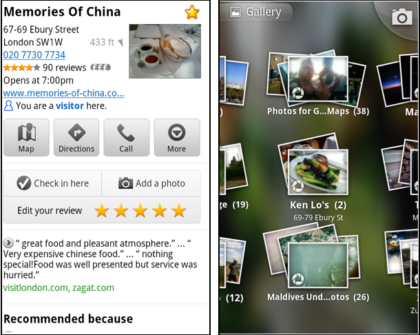
Photo upload for a Place

When deciding on a place to go, people often want to know what a place looks like in addition to seeing ratings and reviews. You can now contribute photos to help others get a sense of places. You can now attach your photos to Places, and yours may even become the profile picture for that page. If you want to view or delete any photos you’ve contributed to Places, you can manage uploaded photos in the “Photos for Google Maps” album on your Picasa account.

Left: Uploading pictures to a place. Right: Photos in Android Gallery

My Places and descriptive terms for mobile

In June we announced descriptive terms and ‘My Places’ for the desktop. Both these features are now in Google Maps for mobile. Descriptive terms appear in search results for Places to inform you what businesses are ‘known for,’ such as their ‘eggs benedict’ or being ‘worth the wait.’

Also, My Places for mobile provides quick access to starred and recent Place pages you’ve looked at. You can access My Places by pressing your phone’s menu button while in Google Maps.

Descriptive terms and My Places in Google Maps for mobile

Add a new Place ‘on-the-go’ for check-ins

If you’re out and about and want to check in, we want to make sure you can quickly add a new Place to check into if one isn’t available. This might happen for new businesses or those that haven’t set up a Place page yet. For example, let’s say you’re at Xoogle Xtreme Sports, a new sports shop in your neighborhood. You go to check in but don’t see Xoogle in the list of places to check into and when you do a search still nothing comes up.

Add a Place when checking in, if needed

To solve this, you’ll now see an “Add place” option at the bottom of suggested places. Select that option, and you’ll be prompted to confirm the name and location of the new place. Then a brand new place is added (and you’re checked in). This place will be available for you and others to check into from Latitude, but will not appear as a search result in Google Maps or Google Places.

We’ve also added ‘Bigger text’ to our experimental Labs features and ‘Download map area’ has been renamed ‘Pre-cache map area.’

To start using Google Maps 5.8 for Android, download the update here. This update requires an Android OS 2.1+ device and can be used anywhere Google Maps is currently available. Learn more in our help center.