Wednesday, July 6, 2011

Google Maps 5.7 for Android introduces Transit Navigation (Beta) and more


(Cross-posted on the Official Google Blog)

Today we’re releasing Google Maps 5.7 for Android. From Bangkok to Baltimore, we’ve added Transit Navigation (Beta), updated access to directions, better suggested search results, and a photo viewer to Place pages—all of which can help you whether you’re traveling to an unfamiliar part of town or visiting a city across the world.

Transit Navigation (Beta)
Google Maps Navigation (Beta) currently provides over 12 billion miles of GPS-guided driving and walking directions per year. Now, GPS turn-by-turn (or in this case, stop-by-stop) navigation is available for public transit directions in 400+ cities around the globe with Transit Navigation.


Transit Navigation uses GPS to determine your current location along your route and alerts you when it’s time to get off or make a transfer. This is particularly helpful if you’re in a city where you don’t speak the language and can’t read the route maps or understand the announcements. After starting your trip with Transit Navigation, you can open another application or put your phone away entirely and Google Maps will still display an alert in your notification bar and vibrate your phone when your stop is coming up.
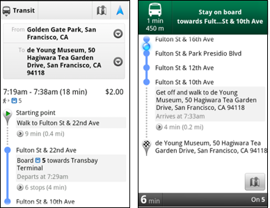
Left: Transit directions without Navigation. Right: with Navigation


Navigation alerts appear even if you switch to another app

Now you can spend more time enjoying the sights out the window and less time worrying about how many stops are left, where you are along the route or whether you missed your stop. Since Transit Navigation relies on GPS signals, we recommend using this feature for above-ground transit.

Updated Directions
Now that we’ve improved our directions services, we wanted them to be incredibly easy to pull up on your screen. If you select the driving or walking icon and your route is supported by Google Maps Navigation, the Navigation icon will automatically appear so you can get access to step-by-step directions in one click. Note: this change is currently only in place for driving and walking and does not appear for public transit.

One-click access to Navigation from directions

We’ve also streamlined how you access directions from within a Place page. Before, clicking directions in a Place page would bring up options for “Driving Navigation,” “Walking Navigation” and “Directions.” Now, you’ll be taken straight to the map and see the new directions box shown above.

Improved Search Suggest
We’ve made two changes to search suggestions that improve their quality and speed. First, we’ve added category icons, so instead of all search suggestions displaying the same icon, the icon next to the listing will reflect the type of result. You’ll see a pin for a Google Places listing, a star for a starred Place or location, a clock for a previously used search term, a person for contacts and a magnifying glass for “anything else.”

Two examples of search suggest with new icons

Also, any place you got directions to or called directly from its Places page will be included as a suggestion for a relevant search. For example, if you recently received directions to the U.S. Post Office on Wilshire Boulevard, afterward, when you begin a search with [p] or [bou], that U.S. Post Office would appear as a search suggestion.

Photo viewer for Place pages
Since we released business photos for Place pages last October, millions of photos have been added to Place pages around the world. To enable you to view these photos on the run, a slick new photo viewer has been added so you can browse photos while deciding where to go.

Left: Business photos in Place pages. Right: New photo viewer

To start using Google Maps 5.7 for Android, download the update here. This update requires an Android OS 2.1+ device and works anywhere Google Maps is currently available. Learn more at our help center and have fun exploring, whether it be by car, transit, bike or foot.

Tuesday, July 5, 2011

Geo Developers at Google I/O 2011


If last year’s Google I/O was about the maturation of many of the Geo APIs, this year’s was more about their sophistication, both in the designs discussed and the applications on display. Like the sun standing still at the solstice, let’s take a moment to reflect on recent events and look ahead to the coming season.

Several new features made their debut at I/O this year. The much-anticipated Places API took the stage, as did its companion the Places Autocomplete API. Dynamic Styling was introduced for Fusion Tables layers in the Maps API, allowing layer styling to be defined by the API application via Javascript. Finally, some extremely helpful open source Javascript libraries were introduced to make Maps API development even easier.

Joining us on stage were several developers who came to share their expertise. Justin O'Beirne of 41Latitude talked about map usability and design in the “Designing Maps Applications for Usability” session. The Guardian UK’s Simon Rogers joined us to talk about how the Guardian is using Fusion Tables to visualize the data they collect in “Managing and Visualizing Your Location Based Data.” Yoni Samlan from SCVNGR also came to discuss developing with the Places API in “Location-based App Development.”

In addition to the sessions led by the Geo team, the developer sandbox featured eight Geo API partners who engaged directly with I/O attendees. Joining us in the sandbox were HistoryPin, Icon Fitness, Ubisense, The Wall Street Journal, Footprint Feed, The Bay Citizen, Arc2Earth, and Travel Game. The apps on display ranged from location-based gaming using the Latitude API to tools for citizen journalists to map public data using Fusion Tables. You can learn more about two of our sandbox partners in these video case studies:
  • The Bay Citizen (video) - The Bay Citizen explains the benefits of the Fusion Tables layer with Google Maps API to build infographics for their online newspaper. The Bike Accident Tracker visualizes the prevalence of bike accidents across San Francisco.
  • Historypin (video) - HistoryPin lets users upload historical photos, geotag them on a Google Maps, and overlay the old imagery on top of new Street View imagery, enabling users to see what their cities looked like at different points in time.


Geo APIs Summer Learning Series (apologies to the Southern Hemisphere)

But at the heart of Google I/O are the sessions themselves. This year, speakers from the Maps, Earth, and Fusion Tables teams covered a wide range of topics, from ensuring high performance and usability across all browsers to visualizing huge data sets with Fusion Tables. The amount of material covered was enormous...but we want to expand upon it.

To that end, we’re pleased to announce the "Geo APIs Summer Learning Series” on the Geo Developers Blog. Over the coming weeks, each talk will be getting its own blog post from the session speaker, pulling in what was discussed at I/O and then digging deeper into the technical content. Here is how the series will unfold:

Week of July 6th
Connecting People and Places
Location Based App Development using Google APIs
Secrets and Surprises of the Google Geo APIs

Week of July 11th
Managing and visualizing your location based data with Fusion Tables
Designing Maps Applications for Usability on Mobile and Desktop

Week of July 18th
High Performance KML for Maps and Earth
Speedy Maps

Week of July 25th
Map your business, inside and out
GIS with Google Earth and Google Maps

If you’d like a head start, videos of all the I/O sessions are linked above. Be sure to visit the Geo Developers Blog throughout July for even more great content from the Maps, Earth, and Fusion Tables teams.

Wednesday, June 29, 2011

Lots of 45º imagery just in time for summer vacation


School is out and it’s time to pack those bags and get ready for summer vacation! We’ve been working hard to get everyone the latest imagery from all over the world. Does your family have any annual traditions? If not, now is a great time to start some, check out our latest additions for some great ideas on where to travel this summer.

What a better way to start a tradition than to visit the happiest place on earth, Disneyland in Anaheim, CA! Use Google Maps to scout out the area, plan out your multi-day adventure all in the comfort of your own home before you head out and enjoy the sites and scenes found there.


View Larger Map

While you’re in sunny Southern California, you can check out Downtown Los Angeles, Universal Studios in Hollywood or visit the Staples Center, home of the 16-time NBA Champions Los Angeles Lakers.


View Larger Map

If you’re a baseball fan, nothing says summer like a good ole fashioned baseball game. Grab your baseball cap and head over to the Baseball Grounds of Jacksonville in Jacksonville, FL, home of the Suns! Downtown is just around the corner from the stadium.


View Larger Map

So whether it’s by plane, train or automobile, from all us at Google, have a great and safe summer. Check out the this map that shows you where all of our 45º imagery lies.

Full list of updated cities:
Anaheim, CA. Jacksonville, FL. Tampa, FL. North Las Vegas, NV. Los Angeles, CA. Downey, CA. La Chaux de Fonds, CH. Visalia, CA. Corona, CA. Meadowlake, NM. Continental Ranch, AZ .Picture Rocks, AZ. Greater Sun Center, FL, Bastrop, TX. Martinez, CA. Paradise Valley, AZ. West New Orleans, LA. Fentress, VA.

Google Earth API and StrataLogica: Changing Education

Cross-posted on the Google Enterprise Blog

Editors note:
The Google team encounters fun and new ways of using the Google Earth and Maps API. Here’s an example of how a century old educational map and globe publishing company realized more students wanted to learn online and transformed their teaching methods to include a program built on the Google Earth API. Don Rescigno, from Herff Jones | Nystrom, explains how students and teachers benefit from technology in the classroom with StrataLogica.


With today's technology enabling information to travel at a much more rapid rate than in the past, students feel more advanced than what many of us can remember from our own days in school. Elementary school students use a school computer, manage multiple usernames and passwords, work with spreadsheets, develop their own blogs and websites, and more. They’re tech savvy and they’re connected.

The challenge for educators is to use tools and resources that take advantage of students' advanced technological skills. Combining educational content with technology like the Google Earth API gave us the opportunity to foster a new and immersive experience that changes the way students see our world.

StrataLogica—combined with the Google Earth API —provides students with powerful tools to visualize and comprehend the ways in which geography has impacted events, politics and populations throughout human history. Students have the ability to see current events, taking place around the world, from their classroom.

Using a computer or interactive whiteboard, students uncover layers of educational content and can then drill down to Google Earth’s satellite imagery, see what’s actually there, and even use historical imagery to compare then and now. Recently, I had to play the role of a teacher when one of my children overheard a CNN report on Japan and asked, “Dad, what made the earthquake and tsunami?” The ability to access and interact with so many resources—aerial imagery of the earthquake, videos, and photos posted by Japanese citizens, local news stories—allowed me to teach him about the Earth’s processes and their impact. It helped to create a better understanding beyond the news story. It fostered critical thinking and a global perspective.


Like so many with children, I want to see students learning in a new way that
inspires them. It’s important for our future generation to understand how we are all connected — to think globally and comprehend world impact. We want them to truly become global
citizens. StrataLogica and the Google Earth API are helping change the way students see the world; they can “fly” to any location in a matter of seconds, zoom in to imagery and see street views of historical sites that they may never have an opportunity to visit, embed videos and photos, and experience their own virtual field trips.

If you’re an educator interested in teaching geography, history, earth science and
more, visit stratalogica.com to learn more.

Street View: Our biggest update yet

Since we launched Street View on Google Maps in the U.S. in 2007 we’ve added 26 more countries and enabled you to explore images across all seven continents. Today we’re excited to share with you the latest expansion of Street View because it’s our biggest update yet.

New imagery is now available for 13 of our established Street View countries: Denmark, Ireland, Italy, Spain, Netherlands, Norway, Sweden, Romania, South Africa, Taiwan, Japan, the United States, and the United Kingdom.

I like wine so I’m particularly interested in seeing the new imagery around Italy’s famous Chianti region and other beautiful areas of Tuscany. Across the mediterranean in Spain, the home of another renowned wine is available with the addition of the Rioja province.

Pechina, Rioja Region, Spain

And as a food lover I’m keen on discovering Denmark’s beautiful chain of Smålands Islands - famous for its fruits that have inspired many Danish chefs and the new Nordic cuisine movement. In neighbouring Sweden there has been a significant increase in coverage across the country with Lake Siljan now included, along with the popular tourist towns of Rättvik, Leksand and Mora.

Leksand, Sweden

The southernmost tip of Africa is also now available with the addition of South Africa’s Cape Agulhas. The cape is where the Indian and Atlantic oceans meet and is notoriously hazardous for sailors.

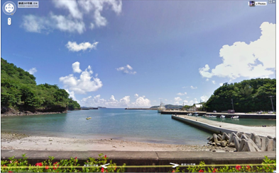
And across the other side of the world, you can view the Pacific Ocean from Japan’s Hahajima, one of the remote Ogasawara islands.

Haha-Jima, Japan

In addition, this latest batch of street-level imagery includes higher resolution panoramic views of places throughout the San Francisco Bay Area, Los Angeles and San Diego. This is great for both locals and potential visitors of these popular California destinations, who can now see even more realistic views of landmarks like the Golden Gate Bridge, Staples Center, and USS Midway.

Golden Gate Bridge, California

Of course, these are just a few of the many fascinating places in today’s release of new Street View imagery, so we encourage you to look around and virtually experience them for yourself right in Google Maps. Be it for armchair travel from the comfort of your computer, or to figure out where you might want to visit on your next vacation, we’re thrilled to continue our expansion of Street View.

Tuesday, June 28, 2011

A Refocused Map


Over the years we’ve made some significant improvements to our map style. This summer, we’re starting a new project to give you more map and simplify the overall look and feel. As part of a larger effort, Google is bringing you an experience that’s more focused, elastic, and effortless.


Before


After


Whether you use Google Maps to discover new places, or to seek out destinations you know well and love, we hope you’ll find our updated look as familiar and reliable. It’s simple polish with focus on what’s most important—your map.

Monday, June 27, 2011

Discover Your World in 3D, again

[Cross-posted from the SketchUp blog]

Today, we’re unveiling a totally redesigned Your World in 3D website. If you’re new to geo-modeling -- the term given to creating 3D buildings for Google Earth and Google Maps -- the Your World in 3D website has all the tools and info you’ll need to get up and running quickly. The new website showcases several examples of what fellow modelers are building and will help connect with other geo-modelers around the world.

So that’s the what, here’s the why. Five years ago, Google acquired a Boulder-based startup called @Last Software, which was making waves in the architectural world with their 3D modeling software, SketchUp. Google had an ambitious idea to add a 3D model of every building on the planet to Google Earth, and SketchUp was a tool up to the task. Not only that, by opening SketchUp to a wider audience, users would have the opportunity to help build a virtual mirror of their world.

Times Square showcases some of the very first user contributed models


Today, the 3D virtual world is in full bloom: hundreds upon hundreds of villages, towns, and cities have been added to the 3D map representing hundreds of thousands of 3D buildings from every corner of the globe -- truly, a testament to the power of open collaboration.

In the intervening half decade, we’ve introduced several new ways of adding buildings to the 3D map, including Google Building Maker and the Cities in 3D program. And you may have noticed 3D buildings surfacing on Google Maps and Google Maps for mobile as well. With so many different ways of creating and viewing 3D models, we realized we needed a destination that would demystify the process of geo-modeling,

Enter: the new Your World in 3D website. We call the website Your World in 3D because it is you, the user, who is helping build this virtual world, and perhaps more importantly, it is you who is finding innovative and surprising ways of using this data.

Your World in 3D has been redesigned from the ground up


Why geo-model? When asked, most geo-modelers say they do it because geo-modeling is just plain fun, but building your town in 3D can also be a great way to show civic pride and encourage tourism for your town. It can also provide an interactive way to promote your business or contextualize the urban planning. 3D modeling has also been used in crisis response situations as we saw in the grassroots modeling effort that happened after the earthquake in L’Aquila, Italy.


Why create 3D models for Google Earth?

We hope you’ll join us on this mission (and adventure) of building the most comprehensive 3D virtual mirror of planet Earth.

Happy modeling!

Posted by Nicole Drobeck, Geo Community Program Manager