As Americans gear up for the midterm elections on November 2, we wanted to share a few tools that make it easier to gather voting information.
When you search on Google for [polling place] or [where to vote], you’ll see a search box to help you find your polling place, candidates, and local election office. Just type in the home address where you’re registered to vote. The search looks like this:
This feature is powered by the Google Election Center, an experimental service that lets election officials provide data directly to Google in order to create a set of search tools. Anyone with a website can also provide this same functionality by embedding the open source Election Center gadget on your site, or use the gadget code or API to build your own.
And you don’t need to be at your computer to easily find this information. If you’d rather get it on your mobile device, we’ve also created a mobile landing page: m.google.com/elections.
As for election news, you’ll find a special Google News section with stories for each state so you can easily catch up on the latest headlines.
We hope all of these tools help you get and stay informed throughout the election season.
Posted by Dan Berlin, Public Sector Engineering Manager
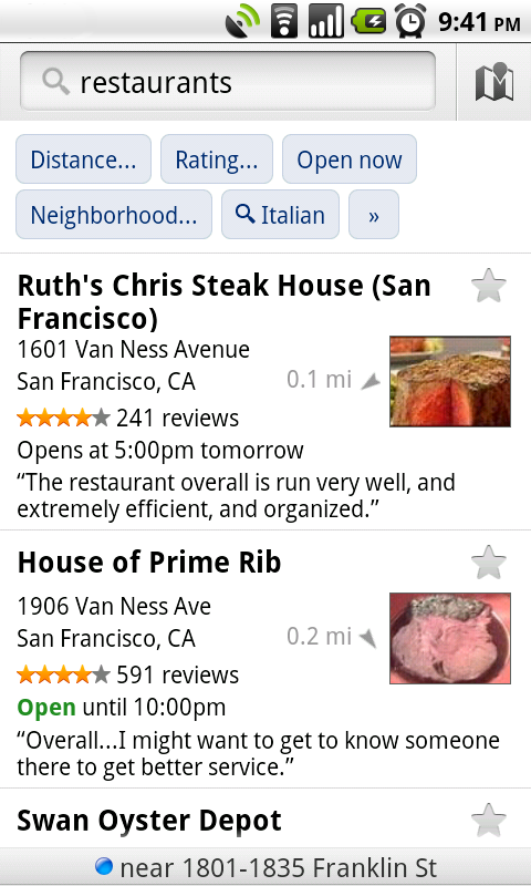
Lately, we’ve been working on giving you even better ways to find nearby places with Google Maps for Android, such as the Places icon and rich Place pages. Today, we are launching Google Maps 4.6 with a new design for Place page reviews, more options to filter search results, and a Google Latitude real-time updating option.
Place page reviews Now, you’ll see that Place pages on Android Maps share the same new design for displaying reviews as used by Place pages on your computer. You can see:
“Reviews from around the web” for highlighting sites that have high-quality reviews about the place.
“Reviews from Google users” for reviews posted directly to Google Maps by other users
Filter search results Of course, you’ll first need to narrow down which Place page reviews to check out. In addition to distance and ratings, you can also filter results for some searches by:
Open now
Neighborhood
Related searches
Find the right place with the updated reviews section (left) or search results filters (right).
Google Latitude real-time updating In Latitude, you can also choose an experimental “Real-time updating” option from an individual Latitude friend’s profile page to help meet up with them by temporarily seeing faster location updates (friends must have Maps 4.6 and Android 2.2+).
Get Google Maps 4.6 for Android 1.6 and above everywhere Maps is already available. Just search for Google Maps in Android Market (or tap here from your phone).
Visit our Help Center to learn more or tell us your feedback and questions in our Help Forum.
Posted by Michael Siliski, Product Manager, Google Mobile Team
Six months ago, we announced the pilot of a project to take photos of business interiors. Through this program, business owners located in the U.S., Australia and Japan could invite our photographers into their establishments to take high-quality images of their businesses. Excitement from interested business owners grew quickly, and we’ve since taken photos of businesses in about 30 cities.
Starting today, the images we’ve taken as part of the pilot can be viewed on the Place pages of participating businesses. Users and potential customers who look online for local businesses can now see more high-quality photos that give them a sense of what a place is really like. The photos may include the storefront, decor, layout, merchandise, food, signage about hours and accepted payment types, and other items that help people learn more about a business and decide if they want to go there. For example, if you’re looking for the perfect restaurant to make a good impression on a first date, the high-quality interior photos might help you decide if the ambiance and atmosphere of a particular place are right for the occasion you’re planning.
Here are a few examples of these high-resolution photos:
Business owners who worked directly with our photographers across these three regions will see the photos from Google on their Place page within the coming weeks. Thanks to all of you who welcomed us into your businesses. We’re continuing to take photos at more business locations, and urge others to let us know if you’d like us to visit you as well.
In the meantime, you can also upload your own photos and videos of your business by signing in to Google Places. By building out your Place page with visuals and other relevant business information - such as hours of operation, offers and more - you’ll help potential customers learn more about you and feel like they know what to expect when they actually walk through your doors.
As a local business owner in today’s day and age, you know that it’s important to have an online presence because that’s where your customers are. In fact, research shows that 97% of people conduct research online before buying locally. Hopefully you’ve gone to Google Places to claim your free business listing that appears on Google and Google Maps. That enables you to share accurate information about your business such as your hours of operation, photos and videos - and now you can do even more.
Today, we’re announcing the availability of a new online advertising solution to help local businesses connect with potential customers in their area. Boost enables business owners to easily create online search ads from directly within their Google Places account. No ongoing management is needed after the initial set up, and this beta is currently available to select local businesses in San Francisco, Houston and Chicago.
Boost ads are eligible to appear in the “Sponsored Links” section of Google.com and Google Maps search result pages. For example, if you’re a restaurant owner in San Francisco who has signed up for Boost, your ad may show up when someone does a related search like the one below, indicating a cuisine and location that matches yours. Beyond the basics like your company name, address, phone number and website, your ad may also include the number of reviews you’ve received, an average star rating and a link to your Place page to help potential customers find additional useful information about your business. When a map appears alongside the results, a blue pin will help folks quickly find your location on the map. Businesses using Google Tags will also see their yellow tag appear in the ad.
To create your ad, all that is required is a short business description, a web or Place page, your business categories and a monthly budget. From there, our system automatically sets up your ad campaign - figuring out the relevant keywords that will trigger your ad to appear on Google and Google Maps, and how to get the most out of the budget you allotted. You’ll only pay when a potential customer actually clicks on your ad, and you can also view basic ad performance data from your Google Places dashboard.
Here is an example of the simple sign up page within Google Places, which takes just a few minutes to complete. To make the process even easier, the “description” and “categories” fields may be pre-populated with suggestions based on the information you provided on the Place page for your business.
We hope Boost provides busy local business owners with a quick and easy way to share information about themselves with the people who look for them online. Placement in the “Sponsored Links” section of the page will, as always, depend on factors such as your ad’s relevance and quality. Boost does not affect the ranking of the free, organic business listings in any way.
As we do with all beta features, we’ll carefully review the data and effectiveness of this trial and may make changes before making decisions about any future expansion. In the meantime, business owners can sign in or claim their listing in Google Places, and select businesses in San Francisco, Houston and Chicago will see an invitation to try Boost in the account dashboard. Interested businesses outside these areas can sign up to receive notification when Boost comes to their area by filling out this form.
Few events in human history have the scale of World War II. Its spatial breadth and temporal extent make it difficult to comprehend by those of us too young to have lived it. There are history books, movies, and photographs, but they portray isolated places and events more than the connected whole. We’ve addressed this by launching historical imagery in Google Earth in a number of new areas, including London in 1945, in coordination with archivists in these countries.
This newly published data shows clearly the reality of everyday life back then — bombed buildings, deprivations, militarization, and the normal appearance of what where then secret facilities. Here, for example, are the “Then” and “Now” views above and around the Map Room — a favorite of the Google Geo team — from which Winston Churchill and his wartime Cabinet led a great nation to victory through perseverance, and of course, maps:
And here are “Before” and “After” images of Heathrow Airport:
Nearly all of 1945 London awaits your exploration. Enjoying it is easy. Just start Google Earth (install it here if you're not one of the 700 million who already have) and type London as your destination in the upper left. Then, click on the clock icon to enable historic imagery. Scroll back to 1945, and feast your eyes on imagery like the intersection of The Cut and Short Streets near Waterloo station showing the bombed/cleared area that is now the Young Vic theatre:
Turning back 66 years of visual history is also possible in war-time Paris, France. Here, you can see monuments to Napoleonic-era victories during war-time occupation, and study scenes of everyday life in those historic times:
the Seine River
the Eiffel Tower
Both of these countries emerged from these tragedies with renewed vigor and optimism, and also, with openness and respect for mapping. You can see both countries today, not only via aerial viewpoints but also in Street View images in Google Earth and Google Maps. For Earth, just click to enable the Street View layer (one of many) in the lower left; and in Maps, drag the Pegman onto your viewport when you’re looking at most anywhere in France or the United Kingdom.
Historical imagery is also already available for several other cities in Europe. Last year we published photos such as the ones below depicting both pre- and post-war Warsaw. In 1935 we see a vibrant city full of people, but in 1945 we are witness to the destruction of 85% of the buildings, along with palaces and bridges:
Thanks to archivists around the world, photos of past times and places are making their way to Google Earth through the historical imagery feature. Once enabled, you can scroll back and forth through time to make and unmake history with your fingertips. In fact, these images might provide you with the view you’ve needed to share your memories of former places and times with others.
Posted by Michael T. Jones, Chief Technology Advocate
Earlier in the year, we were approached by the National Trust for Historic Preservation to discuss how their member communities might leverage Google’s 3D modeling and visualization tools to support downtown revitalization programs. The concept for developing a digital model of a downtown area was conceptualized by the town of McMinnville, Tennessee, which was among the first small towns in the U.S. to organize a community modeling effort. With city budgets under pressure, the Trust was keen to explore how a community modeling approach could be expanded by downtowns across the nation.
The result was “Main Streets in 3D.” The concept was simple; a contest would be held among local Main Street programs where they would outline a vision for how their downtown would leverage a digital model. Five towns would be selected to receive a full day of training to develop 3D models of their downtown using SketchUp and Google Earth. The winning communities were announced in July.
Contest submissions varied from using the digital model for tourism promotion, to city planning, to creating an urban forestry plan – all ideal use-cases for having a publicly available 3D model. Despite the different goals, all five shared a common vision to use their Main Streets in 3D projects to attract entrepreneurs, jobs, investors, and visitors to their towns.
Igloo Studios, an authorized training center for SketchUp, coordinated with leaders in each community to schedule the training sessions. In early October, the last of the five communities gathered its volunteers to learn how to put their downtown on the digital map. Alex Oliver, CEO of Igloo Studios recently blogged about the experience.
With volunteers now trained, the project transitions to the development phase. Models such as these from Oregon City are beginning to appear in Google Earth.
All five communities will deliver a report on their progress at the National Main Streets conference in May 2011.
Reading reviews is one of the key things that people do before deciding if a place is right for them. Whether it’s figuring out where to go to dinner, or deciding which wedding venue to book, reading about other people’s experiences tends to be a critical step in the process. That’s why we think it’s important to help users find the most useful reviews, and sources of reviews, from around the web.
Today, we’re announcing a new design for how reviews are displayed on Place pages. Now, when you look at a Place page for a business, you’ll see a section on the page called “Reviews from around the web.” This section highlights reviews from a variety of sources, and helps you identify the sites that have high-quality, relevant information about a particular place. In many cases, this newly formatted section also provides a quick summary of what you can expect to see, including the number of reviews from each source and the average star rating that reviewers on that site gave a place.
For example, when looking at the Place page for wd~50, you can see that Yelp has some reviews about this restaurant, another bunch are provided by Zagat, and still more are available on Citysearch. If you want to learn more about this place, you can just click through on yelp.com, zagat.com or citysearch.com and read what people on those sites had to say about their experiences there.
In the section called “Reviews from Google users,” you can also read the additional reviews that individuals have posted directly to Google Maps. And of course, you can write your own review to share your opinions about this place and help future potential customers decide if they want to eat here.
We hope these changes to the way reviews are organized help you discover the most useful information about the places you care about from a diverse set of sources and voices. Enjoy checking out the new and interesting places you find!
On October 20th, Comet Hartley 2 will swing by Earth, passing a scant 19 million kilometers overhead. If your 15" telescope is at the shop, it's too cold to star-gaze in your pajamas or you're just having a spate of cometophobia, don't fret, we've got your back.
We've teamed up with the great folks at Slooh.com to deliver a live stream of images straight from their user-controlled robotic telescope network into Sky in Google Earth. Our new Slooh layer features thousands of images taken by Slooh users, with new images being added every few minutes.
You can find this latest addition to Sky in Google Earth by clicking on the planets icon at the top of Google Earth to switch to Sky mode. Then, in the layers panel, open the Current Sky Events folder and click on the Slooh Space Camera layer.
Opening any of the icons in the Slooh layer displays a list of images that have been taken of that object, and clicking any of those will load the image into Sky.
Check out our new layer and see what’s “up,” or head over to slooh.com and try it for yourself. It’s fun and free to sign up. It’s even OK to show up in your pajamas.
Posted by Noel Gorelick, Chief Extraterrestrial Observer
Users search on Google.com and Google Maps because they’re looking for relevant, high-quality content that answers a question or fulfills a need. This useful information often appears in the form of business listings on the search results page, and these free listings are an important way for local business owners to connect with potential customers. We want to help you make the most of your business listing, so this is the first post in three-part blog series about how to set up a clear and effective business listing via Google Places. This first installment delves into the specific topic of business listing titles — also known as your company or organization name — and highlights some of the common issues business owners encounter when creating a listing.
Example of business listings displayed on google.com
Accurately list your basic business information
If you already have a business listing and want to tweak it, or if you haven’t yet claimed your business listing, sign in or visit Google Places here. The “Company/Organization” field will also serve as your business listing title, so you’ll want to enter in the exact name of your business. For example, for a business called “Fly Fishing Frankie’s Ltd.” the following would be its correct business and contact details:
Company/Organization: Fly Fishing Frankie’s Ltd. Street Address: 88 Fish Road City/Town and Postal Code: Fishtown, CA 90210 Main Phone: (555) 555-5555 Website: www.example_for_flyfishingfrankies.com
A clean, easy-to-read title
The title of your business listing should reflect the exact name of your company or organization as it’s used in the real world. While it’s acceptable to leave off company extensions like Ltd, GmbH or Inc, since those identifiers aren’t helpful to users, be sure to avoid adding any descriptions that aren’t part of the official business name or making any modifications to the official name. Your business listing title must match the business name you use in the real world (e.g. on signage, letterheads or business cards) in order to comply with our Google Places quality guidelines. Listings that are in violation of these guidelines may be suspended and won’t appear in Google search results.
Here are some additional reminders about business titles based on some of the offending listings we see and have to suspend. We also let you know how and where to include specific information you want to provide potential customers, while complying with our quality guidelines.
Descriptors and keywords — The following are common examples of modified business titles. These are instances in which either descriptive phrases are used in lieu of the correct business name, or additional keywords and phrases have been added to the business name. These examples are not in accordance with our quality guidelines:
[Example title violation] Professional fishing travels
[Example title violation] Fly Fishing Frankie’s Ltd. entertaining cutter travels
Note: While the “Company/Organization” field may only contain the name of your business, if you’d like to provide more information about your business’s classification or industry, you can do this by selecting the appropriate categories. You can also provide a more detailed description of your business - such as what you do and the the services you provide - in the “Description” field or on your company website.
Location names — Unless the official name of your business includes the name of your city, town or other geographic indicator, adding superfluous location terms to the business title violates our guidelines:
[Example title violation] Fly Fishing Frankie’s Ltd. Fishtown
[Example title violation] Fly Fishing Frankie’s Ltd. in Market Place Shopping Mall
Note: To indicate the location of your business, please use the appropriate fields marked “Street Address,” “City/Town” and “Postal Code.” Adding location-specific information in the title of your listing is not necessary since our system automatically uses your address details to determine the search queries for which your listings would be geographically relevant. If you’re concerned that your business is difficult to find or part of a shopping mall or complex, you can provide users with further guidance about where to find you by adding that information in the “Description” field.
Phone numbers and websites — Phone numbers and website URLs should not appear in your business title. These details should only be entered into their respective fields in your Google Places listing. The following examples of titles violate our quality guidelines:
[Example title violation] Fly Fishing Frankie’s Ltd. (555) 555-5555
[Example title violation] Fly Fishing Frankie’s Ltd. www.example_for_fishingfreddys.com
Capitalization and Punctuation — Some users may be tempted to use special characters or excessive capitalization in the business title to draw attention to their listing. However, this practice is not compliant with our quality guidelines:
[Example title violation] FLY FISHING FRANKIE’S LTD.
[Example title violation] **!!**Fly Fishing Frankie’s Ltd.**!!**
Note: In order to ensure that the Google Places business listing results are useful and easy to read, please refrain from using visual gimmicks. Business titles, as well as addresses, should always use standard capitalization and punctuation.
The above examples may not cover all cases of business title violations, but we hope we were able to highlight some of the common mistakes we’ve seen. By avoiding these errors when setting up your business listing title, as well as reading through the rest of our Google Places quality guidelines, you should be in good shape to create an optimal and compliant listing.
If you realize that your existing listing is not compliant with our quality guidelines, we encourage you to sign in to your Google Places account to make the required changes and avoid getting temporarily suspended for violating the guidelines.
We hope you find this information helpful, and if you have further questions about business listing titles, visit our Google Places help forum.
One-hundred and fifty years ago today, on October 13, 1860, James Wallace Black shot the earliest still-existing aerial photograph in the U.S. He took the picture from a hot air balloon suspended above Boston Common, and the result, titled "Boston as the Eagle and the Wild Goose See It," is truly beautiful. The photo is part of the archive at the venerable Boston Public Library, along with other important historical images of the Boston area, and is particularly significant because most of the area visible in the photo was destroyed by the Great Fire of 1872.
James Wallace Black, Balloon View of Boston, 1860.
From the collections of the Boston Public Library, Print Department, Boston Pictorial Archive.
Flash forward 150 years: Aerial imagery is widely available and used in countless professions, from archaeology to conceptual art. The folks who created Google Earth devised a way to stitch aerial and satellite imagery together into a seamless, searchable map of the world and make it available to anyone with a computer. On top of that basemap of imagery, Google Earth users have contributed to the creation of a 3D, photo-realistic virtual world by using tools like Google Building Maker, which makes it easy for anyone to use aerial imagery to model 3D buildings for display in Google Earth.
We at Google owe James Wallace Black a debt of gratitude; without his early experimentation with aerial imagery, Google Earth may never have come to be.
In a happy coincidence, October 13 is also the first anniversary of Building Maker, and we’re taking the opportunity to celebrate the contributions of a dedicated community of 3D modelers in the 101 cities around the world where Building Maker is available. Here’s a look at two of our top modelers and their creations:
Peter Sih (aka PeterX), lives in San Jose, Calif., but has created models all over the world. He tells us: “Modeling with Building Maker you get almost instant gratification. I learn a lot by modeling places I don't know as well as places I know well. Modeling for GE ties together my lifelong fascination with geography, architecture, travel, photography and computers."
Pavilhão Carlos Lopes - Lisbon, Portugal
Grant Firl (aka Grant F) lives in Fort Collins, Colo., but concentrates most of his modeling efforts on Albuquerque, N.M. He tells us: “I choose to model with 3D Building Maker for many reasons. Principally, I think that the 3D buildings layer is a very worthwhile tool and I view it as both a privilege and a kind of duty to help fill in content. Secondly, it is both fun and rewarding to create models of physical buildings, especially given the opportunity to share them to Google's users for their use and enjoyment. Thirdly, the 3D buildings layer provides a unique way to preserve and share the hard work and inspiration of actual builders and architects.”
Albuquerque Plaza - Albuquerque, N.M.
If you haven’t tried Building Maker yet, it’s very easy and fun. You pick a building and construct a model of it using aerial photos and simple 3D shapes—both of which we provide. When you're done, we take a look at your model. If it looks right, and if a better model doesn't already exist, we add it to the 3D Buildings layer in Google Earth. You can make a whole building in a few minutes.
Technology has come a long way since James Wallace Black took his photo of Boston, and glass-plate-negative box cameras in hot air balloons have given way to airplanes with mounted camera arrays. But what hasn’t changed is how technology gives us new ways to look at out world. Check out Google Building Maker and build the picture of your world.
Posted by Nicole Drobeck, Building Maker Community Advocate
Hot off the satellite, we’ve received brand new Ikonos imagery of the recent sludge spill in Hungary. See the below screen shots for before/after images; you can also view the the imagery in Google Earth using this KML overlay. Special thanks to GeoEye for making updated imagery available so quickly.
Image credit: DigitalGlobe (left) and GeoEye (right)
Image credit: DigitalGlobe (left) and GeoEye (right)
Image credit: DigitalGlobe (left) and GeoEye (right)
Posted by Matt Manolides, Senior Geo Data Strategist
The Google Earth and Maps Imagery team has just finished pushing out a new set of images for you to explore and enjoy. Fall - when the weather isn’t too hot or too cold - is typically a beautiful season in the the American Northeast, and we’ve made some timely updates in the Poconos and Connecticut to help you see the places you might be planning to visit. For all you folks heading to Washington, D.C. for this month’s Rally to Restore Sanity and the March to Keep Fear Alive, we also recently updated our imagery of the D.C. metro area. Check out the all the sites, prepare for you trip, and don’t forget that you can find metro stops from your Google Maps for mobile app!
Jim Thorpe, Pennsylvania
Washington, D.C.
High Resolution Aerial Updates: USA: Allentown (PA), Bridgeport (CT), Stamford (CT), Camden County (NC), Washington DC French Polynesia: Manihi
Countries receiving High Resolution Satellite Updates: Mexico, Cuba, Guatemala, Honduras, Nicaragua, Costa Rica, Panama, Colombia, Venezuela, Ecuador, Peru, Brazil, Bolivia, Paraguay, Uruguay, Argentina, Chile, Poland, Hungary, Slovenia, Croatia, Austria, Serbia, Albania, Montenegro, Macedonia, Bulgaria, Greece, Russia, Turkey, Morocco, Algeria, Tunisia, Libya, Egypt, Mauritania, Senegal, Guinea, Sierra Leone, Liberia, Mali, Ivory Coast, Burkina Faso, Ghana, Benin, Niger, Nigeria, Cameroon, Chad, Central African Republic, Sudan, Eritrea, Ethiopia, Somalia, Kenya, Uganda, Tanzania, Rwanda, Burundi, Democratic Republic of the Congo, Congo, Angola, Zambia, Malawi, Mozambique, Botswana, Namibia, South Africa, Madagascar, Lesotho, Saudi Arabia, United Arab Emirates, Qatar, Jordan, Israel, Syria, Iran, Uzbekistan, Turkmenistan, Pakistan, India, Nepal, China, Myanmar, Thailand, Cambodia, Vietnam, Indonesia, Philippines, Korea, Mongolia, Australia, New Zealand
Countries receiving Medium Resolution Satellite Updates: Cuba, China, India
These updates are currently only available in Google Earth, but they'll also be in Google Maps soon. To get a complete picture of where we updated imagery, download this KML for viewing in Google Earth.
Posted by Matt Manolides, Senior Geo Data Strategist
We’re happy to introduce an easier way to use Google Latitude from your computer at google.com/latitude. You can now see where your friends are, start using Latitude apps, and share your location all from one place when you’re at your computer.
Find your friends We launched Latitude with a desktop iGoogle gadget to help you stay in touch with friends and family that may not have a smartphone. We’ve since learned that a desktop experience is important to you even if you’re already using Latitude on your phone. Today, you can now visit a dedicated site that makes it easier than ever to use Latitude when you’re already on your computer. From the Friends tab, you can:
See where your friends are on Google Maps
Add friends and accept sharing requests
Control your privacy settings
Do more with Latitude You’ll also now find Latitude and Latitude apps together in one place. After browsing your friends list, go to the History or Apps tabs to turn on optional Latitude apps such as:
Share your location Just like on your phone, you can choose to share your location with friends and family from your WiFi-enabled computer. Before you can share your location, you’ll need to first give Latitude permission to access your location when prompted by your supported browser. You can always change your browser or Latitude privacy settings later. Learn more in the Help Center.
To get started, go to google.com/latitude on your computer. If you’re new to Latitude, you can then start on your phone by sending yourself a text message or choose to start on your computer.
Posted by Kenneth Leftin, Software Engineer, Google Mobile Team
Panoramio is a community photo-sharing site for geo-located images. Photos uploaded to Panoramio show up on its website, as well as other places such as Google Earth and Google Maps.
We’re excited to announce that detailed statistics are now available to users directly within their Panoramio account. Think of Panoramio Stats as a photo-specific version of Google Analytics for Panoramio - in other words, a powerful web analytics tool that helps you measure the performance of your photos. With this new feature, you can track the sites from which your photos have been viewed in visually appealing and intuitive reports.
These statistics are available for every photographer and surface granular information about each photo. For example, a reports for the last 30 days can be broken down by referral domain so photographers can see how many times their photos were viewed within Panoramio, on Google Earth, Google Maps, and through Panoramio’s Widget API.
Additionally, Panoramio Stats helps you identify your most recently viewed and most popular photos, and lets you know about new referral sites so you can track the latest online activity around your photos and figure out what types, styles or genres of your photos generate the most interest and help you improve your craft.
As always we’d love to hear your thoughts on this cool new feature, so feel free to leave us your comments in the Panoramio Forum.