Tuesday, November 30, 2010

A whole new world of Street View


Google Earth has always enabled you virtually fly around the world from the comfort of your home, but there are a lot of great places to explore on the ground as well. So when we sat down to enhance the Street View experience for version 6, we focused on improving not only how you fly around but also how you land and explore the world at street level. Although Street View is technically a big collection of photos, we want you to feel like you’re actually walking down the street instead of jumping from photo to photo. Today, we’re proud to show off this concept in the new version of Street View in Google Earth 6.


To do this, we took the ideas that were developed for Smart Navigation in Google Maps and pushed them even further. Using the panoramic images and 3D depth data from our Street View vehicles, we built 3D street scenes and integrated them into Google Earth. As you move along the street, we blend together different panoramas to create the illusion of one continuous 3D scene.

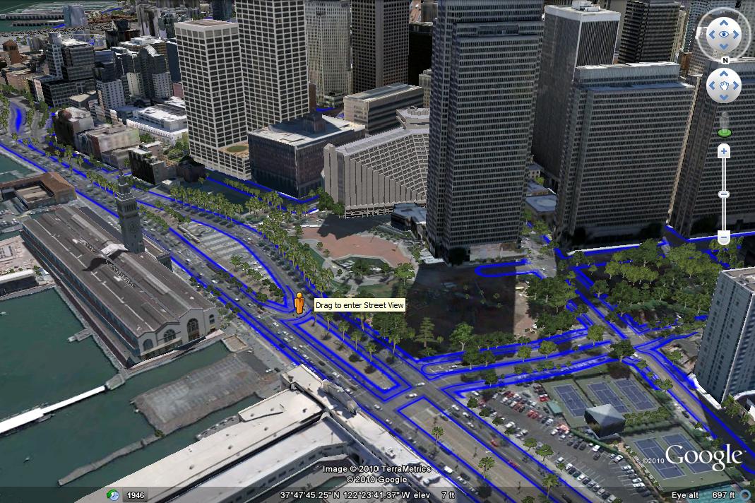
To help you navigate, we’ve also added new controls for ground-level viewing: use the scroll-wheel to move forward and backward, double-click to move towards a point, and click-and-drag to look around. Since we don’t have images for every viewpoint in the world, moving away from the spot where a photo was taken can look weird at times. So using the double-click and scroll wheel features will navigate you to the clearest view. For the more adventurous, the keyboard arrows also enable you move freely through the environment but with some distortion.

Because Street View is now fully integrated into Google Earth, your place in Street View matches your location in 3D. This means that you can easily see 3D buildings, terrain, and now 3D trees by toggling from Street View to ground-level view — simply click on the building icon in the navigation controls. Take a look at these two different images of the same location, one in Street View and one in ground-level view.


The easiest way to enter the new Street View experience is by grabbing the Pegman from the navigation controls, and dropping him wherever there is a blue highlighted road. You can also enter Street View by zooming in close to the ground. And of course, you can exit at any time by clicking on the “Exit” button.

So head out and explore the world from the streets! Here’s a tutorial video to demonstrate how to use the new Street View in Google Earth 6:


Posted by Greg Coombe, Google Earth Engineer

Video: How To Hotpot

[Cross-posted from the Hotpot Community Blog]

As you know, we recently announced the launch of Hotpot, our new local recommendation engine for Google Places, powered by you and your friends. In the following video, Mat Balez, a Google product manager, talks more about how to find the places you'll love using Hotpot.


Posted by Vanessa Schneider, Hotpot Team

Learn about the human side of climate change with Kofi Annan

[Cross-posted on the Google.org and Official Google Blog]

Climate change is too often misunderstood to be simply an environmental issue, rather than a human issue. For our children and grandchildren, climate change is an issue of public health, economics, global security and social equity. This human side of climate change is explained in a new Google Earth tour narrated by former U.N. Secretary General Kofi Annan. Within these stories, you’ll find data and tools to explore this topic in more depth, and meet some of the people who are actively working on managing the risks of climate variability and change. We encourage you to take the tour to learn more about these human issues and the inspiring work of groups like the Alliance for a Green Revolution in Africa (AGRA) that are helping farmers cope with climate change. We hope this video will serve as a useful tool as educators help students around the world understand the complexity of this issue.


This is the latest in our series of climate change tours that we’re releasing leading up to the global U.N. Framework Convention on Climate Change (COP16) talks in Cancun, Mexico this week.

As part of the Google Earth for Educators Community, we’ve also created a special Climate Change Educators Resources page that teachers can use in their classrooms. Here, teachers can find the tools they need to create lesson plans about climate change, including all the individual Google Earth KML layers available for download. Teachers and students can overlay multiple data layers that help illustrate climate change, and discuss and analyze them as part of K-12 and higher education curriculum. We’re also looking for lessons plans for any school grade that use this narrated tour or these Google Earth KML layers, so if you’re a teacher or instructor, please submit your lesson plan for review now.


Visit google.com/landing/cop16/climatetours.html or the Climate Change Educators Resources page to learn more about climate change today.

Monday, November 29, 2010

Mapplets to transition out of Google Maps

[Cross-posted from the Google Geo Developers Blog]

Earlier this year we announced the deprecation of Google Mapplets. As part of the deprecation plan for Mapplets we will shortly be switching from rendering Mapplets within Google Maps, to rendering them on a dedicated Mapplets page:

http://maps.google.com/maps/mapplets?moduleurl=http://www.google.com/ig/modules/geoscratchpad.xml

In conjunction with this transition the Google Maps Directory will be closed, and links to Mapplets will be removed from the My Maps tab in Google Maps.

Bookmarks for existing Mapplets will continue to work. They will be automatically redirected to the new Mapplets page for the relevant Mapplet. The Mapplets page also has the minimum necessary UI elements so that it is better suited to embedding in third party sites using an iframe.

However because the Mapplets page is not part of the Google Maps application, Mapplets will no longer have access to Google Maps user profiles, which means that User Preferences will no longer be stored between sessions. Users accessing Mapplets will now always see the default behaviour when the Mapplet first loads.

The above changes will be made on or shortly after Wednesday December 8th 2010. If your web site recommends one or more Mapplets by linking to the Directory we recommend that you update your site to link directly to the Mapplets page, or embed the relevant Mapplets page in your site, as soon as possible.

3D Trees in Google Earth 6


We strive to provide as much realism as possible in Google Earth, but until now, trees have largely been missing from the landscape of our product. Trees have been modeled individually in a handful of locations, such as Disney World and the Eiffel Tower, and we’ve learned from those instances to make sure we could represent trees in a realistic way that could scale to places where trees exist en masse, like urban parks and large forests.

Over time we’ve developed a way to produce highly detailed, photo-textured versions of specific tree species and reproduce them at large scale. In the new release of Google Earth 6, people in several cities will now be able to browse 3D trees in some of their favorite parks, and maybe even pick out a spot for their next picnic! Our urban tree coverage includes San Francisco (downtown and Golden Gate Park), Chicago (Grant, Millennium and Lincoln Parks), New York City (Prospect and Riverside Parks), Athens (Thiseio Park, the National Gardens, Lykavittos Hill and around the Acropolis), Berlin (Tiergarten Park) and Tokyo (Yoyogi Park, Shinjuku Gyoen and the Akasaka Imperial Grounds). Prospective students can even scope out the beautiful greenery on campus at the University of California, Davis.

With 3D trees in Google Earth, we’ve brought characteristic trees to life, from the palm trees that dot San Francisco's bayfront Embarcadero Street, to the olive trees that cling to the Acropolis in Athens, to the flowering dogwoods found in Tokyo’s parks. All told, there are around 50 different tree species to explore in Google Earth and counting!


Of course trees also grow and flourish outside of cities. In fact, urban trees only make up a very small percentage of the estimated more than 400 billion trees on our planet. In order to tell the greater story of trees on our planet, we worked with several environmental organizations to model reforestation projects and protected forests in Google Earth. Working with Nobel Prize winner Wangari Maathai’s Green Belt Movement, we modeled five tree replanting sites in Kenya. These sites represent just a small part of the Green Belt Movement’s work planting more than 40 million trees to restore the environment and improve the lives of people who are linked to the land.

We also worked with the Surui people, an indigenous group in the Amazon who are working to protect their rainforest from illegal logging. The Surui and one of their partners, the Amazon Conservation Team, selected some of their most culturally significant trees, including the acai palm and the cashew tree, to be modeled for this project. The resulting 3D visualization enables Google Earth users from all over the world to experience the magic of the Amazon rainforest.

Our third partner, CONABIO, supports and protects Mexico’s biodiversity through an ambitious forest monitoring project that tracks changes in forest health and cover over time. This project has helped define priority forests that need urgent attention and protection, like the two mangrove forest areas that we’ve modeled in Google Earth. These forests that hug the Mexican coastline provide unique habitats for wildlife animals like crocodiles and jaguars that depend on these sensitive ecosystems to survive.

This first release of 3D trees in Google Earth includes more than 80 million trees to study and explore. But we’re not content to rest on our virtual laurels, so look out for trees in more cities and forests soon!

To start exploring 3D trees in Google Earth, first download Google Earth 6. Then explore our tree showcase, where you will find links to tours of trees in San Francisco, Tokyo, Athens, the Surui forest, and more.

A view of the 3D trees in Chicago's Lincoln Park

Posted by Raleigh Seamster, Program Manager, Google Earth

Introducing Google Earth 6—the next generation of realism

(Cross-posted from the Official Google Blog)

Today we’re introducing the latest version of Google Earth, our interactive digital atlas. Now you can explore your childhood home, visit distant lands or scope out your next vacation spot with even more realistic tools.

In Google Earth 6, we’re taking realism in the virtual globe to the next level with two new features: a truly integrated Street View experience and 3D trees. We’ve also made it even easier to browse historical imagery. Over the next several days, we’ll be digging deeper into these great new features, but here’s an overview to whet your appetite.


Integrated Street View
When Google Earth was first introduced, people were wowed by the ability to virtually fly from outer space right down to the roof of their house. While flying over rooftops gives you a super-human view of our world, the ground level is where we experience our daily lives. We took our first baby steps toward bringing the Google Earth experience to street level with our implementation of Street View in Google Earth in 2008, which enabled flying into Street View panoramas. In Google Earth 6, the Street View experience is now fully integrated, so you can journey from outer space right to your doorstep in one seamless flight.

Now, you’ll notice that Pegman is docked right alongside the navigation controls—an ever-present travel companion ready whenever you want to get your feet on the street and take a virtual walk around. Just pick up Pegman and drop him wherever you see a highlighted blue road to fly right down to the ground. Once there, you can use the navigation controls or your mouse to look around. And unlike our earlier Street View layer, you can now move seamlessly from one location to another as if you’re walking down the street by using the scroll-wheel on your mouse or the arrow keys on your keyboard. If you want to visit somewhere farther away, simply click the “exit” button and you’ll immediately return to an aerial view where you can easily fly to your next destination.

Drag and drop Pegman to enter Street View. The blue lines indicate where Street View imagery is available.

3D trees
I think we can all agree that our planet without trees would be a pretty desolate place. Besides the ever-important task of providing us with the oxygen we breathe, trees are an integral part of the landscape around us. In Google Earth, while we and our users have been busy populating the globe with many thousands of 3D building models, trees have been rather hard to come by. All that is changing with Google Earth 6, which includes beautifully detailed, 3D models for dozens of species of trees, from the Japanese Maple to the East African Cordia to my personal favorite, the cacao tree. While we’ve just gotten started planting trees in Google Earth, we already have more than 80 million trees in places such as Athens, Berlin, Chicago, New York City, San Francisco and Tokyo. Through our Google Earth Outreach program, we’ve also been working with organizations including the Green Belt Movement in Africa, the Amazon Conservation Team in Brazil and CONABIO in Mexico to model our planet’s threatened forests.

To enjoy these leafy additions to Google Earth, make sure you turn on the 3D buildings layer on the left side panel. As a starting point, try a search for “Palace of Fine Arts San Francisco.” Once you arrive at your destination, click the zoom slider. You’ll then be taken down to the ground where you can use our new ground-level navigation to walk among the trees.

3D trees in San Francisco, California

Easy-to-use historical imagery
One of the features people told us they liked best in Google Earth 5 was the availability of historical imagery, which enables you to visually go back in time to see such things as Warsaw in 1935, London in 1945, and Port-au-Prince Haiti before and after the devastating earthquake of January 2010. But it wasn’t always obvious when historical imagery was available for a particular place, making this feature one of Google Earth’s lesser-known gems.

So with this new version, we’ve made it very easy to discover historical imagery. When you fly to an area where historical imagery is available, the date of the oldest imagery will appear in the status bar at the bottom of the screen. If you click on this date, you’ll instantly be taken back in time to view imagery from that time period. You can then browse through all the historical imagery available for that location, or simply close the time control and return to the default view.

The site of Google's Mountain View campus in 1948

To download Google Earth 6, or to see videos of our newest features, visit http://earth.google.com.

Wednesday, November 24, 2010

How ratings and reviews work on Google Places


Ratings, reviews and recommendations play an important role in helping people find great places they love. Now that Google Hotpot is available, we want to take the opportunity to share some details on how the Google ratings and reviews system works and remind you of some of the features we’ve launched over the last couple of months.

Whether you’re trying to find a restaurant for some out-of-town relatives or looking for a reputable watch repairman in your neighborhood, your decision-making process is likely to include reading reviews online so you can pick a place that’s right for you. Google helps you find these helpful perspectives about local businesses and services regardless of where on Google you started your search.

Where reviews appear
On the Place page of a business, the “Reviews from around the web” section shows results from the most relevant review sites from across the Web.

In the “Reviews from Google users” section you can read additional reviews that people have posted directly on Google Places. And of course, you can rate the place and write your own review to share your opinions with your friends and other users.


And now with Hotpot, some Place pages may also include a new section called “Recommended because,” which shows you what the friends you’ve added in Hotpot think about various places through their star ratings and reviews.


Also with the addition of Hotpot, if you’re signed in, we’ll use the ratings and reviews from you and your friends to show personalized recommendations in Google search results. These opinions from the people you trust will also be available when searching on Google Maps and Google Maps for Android.


How we handle reviews
We want people to see ratings, reviews and recommendations that are relevant, helpful, and trustworthy. Unfortunately not all reviews and ratings found across the web are entirely honest or legitimate. So to protect both business owners and customers from fake or malicious reviews, we have systems in place that may remove individual reviews from appearing in our products. Our review posting guidelines offer tips for writing thoughtful reviews and provide reasons why reviews are sometimes removed.

Sometimes our algorithms to combat abuse may flag and remove legitimate reviews by mistake. We know this is frustrating when it happens, so we work hard to minimize these instances in our effort to provide reviews that are authentic and useful.

How to flag or respond to reviews
If you believe a review in the “Reviews by Google users” section violates our posting guidelines, you can use the “Flag as inappropriate” link next to the review to report it. We will then investigate if the review violates our guidelines.


However, it’s important to remember that reviews are a forum for users to share both positive and negative opinions. We do not arbitrate disputes and more often than not, we leave the review up.

If you received a review you do not agree with for your business, you can publicly respond on your Place page using business owner responses to reconcile the situation. We know a negative review can be frustrating, but don’t be discouraged. We also provide suggestions on how to engage with customers online to address their concerns and potentially turn an initially negative experience into a positive one.

For the benefit of users who read about other people’s experiences to determine where they want to go, we’re constantly working to improve our review system. At the same time, these continual tweaks also help business owners who use these methods of feedback to learn more about what their patrons think about their offerings.

We hope you continue sharing your thoughts to help yourself and others discover great places, and that the reviews and recommendations you receive from us help you find spots you really love. And if you’re a business owner, we also hope these ratings and reviews bring happy customers through your door.

Posted by Stephan Seyboth, Product Manager

Monday, November 22, 2010

Even smarter Street View navigation: single click to go (anywhere!)

Last year we introduced Smart Navigation to Street View, which allowed you to jump to a new panorama just by double-clicking on a place or object. Now you can quickly navigate to those images with just a single click.

For those of you who haven’t used this click-to-go feature before, notice that as you move your mouse around in a street view panorama, a disk or rectangle follows the cursor (what we call the “pancake”). This pancake not only makes the panorama feel three-dimensional, but shows you where you can jump to a new panorama to get a different view. For instance, let’s say you’re checking out the town of San Miguel de Allende in Mexico because you read about the large community of artists and writers living there. You can get a closer look at the Parish of San Miguel by clicking on the pancake and navigating around the church.


A few more clicks will take you through the colorful neighboring streets. Through your virtual exploration, you can see a restaurant in the distance behind the below rectangular pancake:


With a single click on the pancake, you’re transported right in front of that location and the pancake reappears - this time with a magnifying glass. This means you can zoom in to get an even closer view:


To read the menu at “El Infierno” and see what kind of food they may have, the single click to zoom also applies here. We’ve also made it easier to zoom out. Once you’ve zoomed in all the way, the magnifying glass changes from a plus sign to a minus sign, signifying that the next click will zoom all the way out.


QUE VIVA single click navigation!

Posted by Daniel Filip, Senior Staff Engineer

In Africa, citizen cartographers tell their stories through their maps


Earlier this month, we invited 60 of Google Map Maker’s top users in Africa to a community workshop in Nairobi. The event celebrated the contributions of exceptional mappers from across Africa who have collectively mapped hundreds of thousands of roads, cities and buildings, covering more than half the population in Africa. Participants from places including Burkina Faso, the Democratic Republic of Congo, Ethiopia, Gambia, Kenya, Morocco, Uganda, Rwanda, and Tanzania came together for this unique and inspiring opportunity to tell their stories, learn from each other, and share their mapping experiences using Google Map Maker. Check out the the Super Mappers Conference site for more details.


Meeting these passionate online mappers inspired all of us to think not only about creating maps to fulfill a practical need, but also about why we map and the deeply personal stories a map can tell. During these two days, we traveled to places that we perhaps may never see in person, but now mean more to us when we see them on a map because of the stories of mappers such as Noé Diakubama.

Noé grew up in the Democratic Republic of Congo (formerly Zaire), a country that has suffered many years at war. He is now living in Belgium and proud to give back to his country and people via mapping.

His mapping story began in Mbandaka, where he grew up. Noé liked to walk. Walking was about exploration and discovery. And Noé had many places to go, including secret spots to find wild vegetables and the EALA botanical garden. But without a map it was easy to get lost, so he could never wander too far from home. With his uncle, Noé sketched a small paper illustration of Mbandaka and its landmarks - that was his first experience with mapping! A few years later, he was surprised to find Mbandaka poorly represented on Google Maps; it only showed the city airport and two roads. Using Google Map Maker, he began mapping the roads by himself, and then asked friends and family to help him with adding local roads, their names and so on. Together, they created the first map ever of Mbandaka!


When I asked Noé why he maps, he replied:

Everyday, I spend hours and hours in front of my computer… mapping. My rewards include seeing a smile on the face of someone who sees for the first time the name of his/her street on the Internet, and knowing that someone benefited from the maps I created - kids journeying in the neighborhoods, business owners, or tourists. And ultimately, I want to see Africa being mapped and these maps made accessible to everyone. My message to other Africans: don’t be just a spectator, let’s all share our knowledge and start mapping cities and remote areas. We will soon, together, complete the mapping of our continent!

I’m used to seeing maps and thinking of them as a collection of edits or points of interests. It was an incredible feeling to personally meet and interact with the people behind the creation of the many dots on our maps. This was a gentle and welcome reminder that maps are not static. They’re alive, they’re personal, and they tell the stories of the people who create them. Mapping allows each of us to be a driving force for change and growth in both our immediate communities and the rest of the world. Let’s continue mapping, let’s stay connected through the Map Your World Community, and let’s continue doing amazing things together!

Posted by France Lamy, Program Manager, Google.org

Friday, November 19, 2010

Earthquake motivates New Zealanders to model their town


Last week, local volunteers in Christchurch and Dunedin New Zealand invested a day of their time learning how to create 3D models using Google SketchUp. The workshops focused on learning how to geo-model, a process that involves creating 3D models of buildings from photographs for display in Google Earth.

The workshop was led by local architect and geo-technology expert Jason Mill of ZNO, who was inspired to organize the events following the recent earthquake in his hometown of Christchurch. As an architect, Jason recognized the value of having a publicly accessible digital model of the city, and has invested considerable time over several years modeling the central business district of Christchurch.

The value of these models took on new meaning when many of the heritage buildings in town disappeared, leaving the community to decide what should stand in their place.

Five hours away, the city of Dunedin was unaffected by the earthquake, but given its large number of heritage buildings, local residents there decided that it shouldn’t assume that they will be there forever. They suddenly felt a greater sense of urgency around creating a historical record of these buildings.


Historic preservation and city planning are two reasons that many people model their town, but there are numerous other benefits. Local business owners are keen to be represented on the 3D map, enabling virtual tourists another means to locate them on the Internet. Downtown organizations responsible for promoting their city are other beneficiaries. Exploring a destination virtually, whether for business or leisure, is becoming as common as reading a web site.

Google supports these workshops because it aligns with our mission to build a comprehensive atlas of the world online. This atlas is a dynamic, collaborative, open platform for visualizing, sharing, and searching geographic information—whether it’s in your local neighborhood or on the other side of the globe.

By providing free authoring tools like SketchUp and Building Maker, we’re making it easy to introduce 3D buildings to the map. Maps are no longer just 2D static images on paper, they’re living reflections of the local world around us. Everyone has the ability to help shape the map and contribute their local knowledge, experiences and points of view. Adding 3D buildings to the map is just one way to achieve that.

Local residents such as those in Christchurch and Dunedin are doing more than just putting their cities on the map, they’re contributing to an atlas of the world, and becoming the curators of the special places that their cities have to offer.

Posted by Bruce Polderman, Product Manager

Thursday, November 18, 2010

Street View comes to 20 German cities


Two weeks ago, we celebrated with the people of Oberstaufen when we made available the first ever images for Street View in Germany. Today I’m pleased to let you know that you can explore even more of Germany because we’ve just released 360-degree, street level imagery of Germany’s 20 largest cities, including Berlin, Hamburg, my home town of Munich and more.

If you haven’t yet been to Germany, or if you simply want to refresh your memory from a previous visit, here are some places that might be fun to explore. These panoramic images that virtually transport you without the hassle of a plane ticket are now accessible directly from Google Maps.

Okay, I know it’s obvious, but the Brandenburg Gate in Berlin is one of Europe’s most iconic monuments:


For a complete change of scenery, check out this traditional German architecture, near Hamburg’s historic port in Speicherstadt:


And here’s a personal recommendation for a place where I spend a lot of time and is a good example of a traditional German cafe:


In this latest Street View release, we’re also making some improvements to the way we obscure images of houses, cars or people when asked to do so using our “Report a problem” tool. Our new manual blurring process completely blocks out a house, car or person, but no longer cuts out all the surrounding scenery as well, such as a nearby street sign or trees. This enables us to respect requests for removal without blacking out the entire area. You can see an example below.


Since first using this new blurring method in Germany a couple of weeks ago, we’re now rolling this out everywhere Street View is available for all new removal requests. As always, people should continue to use the “Report a problem” tool and we’ll review all requests promptly.

We hope you enjoy your virtual travels to Germany!

Posted by Andreas Tuerk, Product Manager

Wednesday, November 17, 2010

New Japanese 3D cities available in Google Earth

[Cross-posted from the SketchUp Blog]

Today, we’re happy to announce that three more Japanese cities are viewable in 3D in Google Earth: Yokohama, Sendai and Saitama.

Sun rising over Yokohama.

You can now tour photo-realistic, 3D buildings in these cities without leaving your house—or climbing aboard a shinkansen.


If you’d like to extend your virtual stay in Japan, you can take a tour of Tokyo, Kobe, Osaka or Kyoto, which are also available in Google Earth’s 3D Buildings layer.

We want to thank the many users who modeled and contributed 3D buildings for these Japanese cities. If you’re interested in creating buildings for your town—or for any town—we have several easy-to-use tools to get you started.

With Google Building Maker, you can create and contribute a building in as little as 10 minutes. In Japan, Building Maker is available for the following cities: Fukuoka, Hiroshima, Kobe, Kyoto, Nagoya, Osaka, Saitama, Sapporo, Sendai, Tokyo and Yokohama. And if you’d like to refine your building bring it into Google SketchUp for fine-tuning.

Happy modeling!

Posted by James Therrien, Google Geo Group

Tuesday, November 16, 2010

Getting from A to B just got a little easier


Over the past year, the Google Maps Directions team has been hard at work developing a variety of design improvements to make getting and following directions much easier.

It’s now simpler than ever to switch transport modes, change the time/date of your trip, get a high-level overview comparing different routes, and view details of a single trip at-a-glance.


To explore these improvements in more depth, let’s imagine that you’re planning a trip to visit the beautiful city of Zürich, and would like to take public transportation from the airport to your destination in town.

We’ve made it super quick and easy for you to see all the available modes of transportation when you’re planning a route - you can see that driving, public transit, and walking are all available in this area. The options for setting a time and date for your trip are also now open by default for public transit:


Having selected your start location and end destination, you are presented with a series of suggested routes to take you from A to B. Each description is now much richer, making it easier to differentiate between similar routes:


Once you select a route, the individual steps for the trip are dramatically simplified and cleaner in the new design. The stations at which you’ll need to transfer, and the number of stops in between are now much more apparent. The sections of the route that involve walking are also much easier to spot since they’re indicated by a dotted line on the left:


Clicking on any step will also display more information. For example, we now show the stop preceding the one where you’ll need to get off, so that you can get your bags ready and prepare to disembark. And we’ve introduced turn-by-turn direction indicators for walking, driving and cycling:


Stay tuned for further changes as we continue to refine and improve your experience using directions from Google Maps. Enjoy your travels!

Posted by Jonah Jones, User Experience Designer

Google Boost: Now available in additional U.S. cities


We recently announced that our new search advertising program, Google Boost, is available to local businesses in San Francisco, Houston and Chicago. Based on the great feedback and results from early participants, the beta is expanding to additional U.S. cities. Starting today, select local business owners can sign in to their Google Places account and try Boost if they’re located in San Jose, Seattle, Wichita, Charlottesville (VA), Atlanta, Chapel Hill, Orlando, Washington D.C., Boston, Cross Plains (TX) and Portland (ME). We’ve also made Boost available for all local businesses in Illinois.

A Boost ad for Houston-based Click Photography, and it’s corresponding blue map pin

For those of you who are not yet familiar with Boost, it’s a quick and easy way for local businesses to market themselves and connect with potential customers in their area. Based on the information you’ve already provided on the Place page for your business, we provide a suggested ad description, a web or Place page, your business categories and a monthly budget. Once you’ve confirmed these four simple elements, our system automatically creates an ad campaign. Your ad may start appearing almost immediately when people in your area search online for products and services related to your offering. And what’s more, you’ll only pay when a potential customer actually clicks on your ad. To be clear, the ranking of Boost ads in the “Ads” section of the Google.com and Google Maps search results pages are based on relevance and quality factors; and Boost ads do not impact the ranking of your free, organic business listings.

Over the next week, eligible businesses in the cities mentioned above will see an invitation to try Boost when they sign in to their Google Places account dashboard. Business owners located outside of these areas can fill out this form to be notified when Boost expands further to their regions.

Posted by Kiley McEvoy, Product Manager

Monday, November 15, 2010

Discover Yours: Local recommendations powered by you and your friends


There’s something so exciting about discovering new places. Nothing beats finding a great new place I’ve never been—whether it’s a new bakery with a special dessert, a hole-in-the-wall Mediterranean place I didn’t notice before or a local art gallery where I can let my imagination roam free.

The challenge with finding those great places is that each of us has different tastes. I want to find places I like and I want to find them quickly. So when I’m overwhelmed with possibilities, I turn to sources I can trust. For example, if I’m in a new city, I might chat with the concierge at my hotel and explain to him the kinds of places I like so he can give me personalized recommendations, or I’ll ask my friends for local recommendations because I value their opinions and we have similar tastes. But finding trusted advice is hard; wouldn’t it be great if there was a way for me to get these recommendations all the time, everywhere I go?

We are trying to do exactly that, and today we’re excited to share the first step: an early release of Hotpot - a local recommendation engine powered by you and your friends. With Hotpot, we’re making local search results for places on Google more personal, relevant and trustworthy. There are three main ingredients in the Hotpot recipe:
  • Google Places - These are the 50 million places around the world for which we have rich details.
  • The places you like - When you rate places you like, we’ll tell you about other related places you’ll love. I love my favorite neighborhood restaurant in Noe Valley, Firefly, so when I rate it 5 stars, Hotpot will try to recommend other places for me in the city with simple, homey food such as Home restaurant.
  • The places your friends like - Share your ratings with your friends and see the places they’ve recommended. I’m planning a trip to Barcelona for the holidays and my friend Bernardo is a local. With Hotpot, I can see his recommendations when planning my trip on Google Maps, or when I’m in Spain using Google Maps or Places for Android.

Combining these three ingredients makes the hard task of choosing where to go easy; all you need is to rate places and add your friends. To do that we created the Hotpot rating app: quickly rate all the places you’ve been to and choose exactly which friends you want to invite to Hotpot. Then, when you’re visiting places, you can continue rating on the go from Mobile maps on Android.

Rate from the Hotpot rating app


Rate from Mobile maps on Android

Your recommendations are with you whenever you need them. In search results, you can see recommended places by using the new Place Search and clicking on the “Places” filter. You can also see recommendations when searching on Google Maps, Google Maps for Android or when checking the Place pages for a specific business.

Recommendations on Place Search


Recommendations on a Place page


Recommendations on Google Maps for Android

You can set a Places nickname (here’s how) when you start using Hotpot, so you control how you post your ratings. That way, only your friends will be able to see your real name.

Happy hotpotting!

Posted by Lior Ron, Product Manager

Friday, November 12, 2010

New panoramic photos in Google Earth


Viewing photos in Google Earth has long been a popular activity for avid virtual globe-trotters. It's one of the best ways to "visit" places all over the world without paying for a plane ticket or getting jet lag. Today, the Google Earth photo viewing experience just got better with the addition of panoramic images.

People using Google Earth will find a new "Photos" layer that includes not only the existing 2D photos from the Panoramio community, but also panoramic photos from around the world contributed by users of 360cities.net. These high-resolution panoramic photos are marked in Google Earth as red square icons. When you click on one of these icons, an info bubble containing an image appears, and clicking on the image again will take you into our photo viewing mode. You can then look around in 360-degree views and experience the place as if you’re standing right at the center of it.

new "Photos" layer on Google Earth


info bubble on Google Earth


These panoramic photos are shot by average people just like you and me. To contribute your panoramic photos, visit 360cities.net. We invite all users to become part of the community and mark your photo journey in Google Earth.

Check out some of the beautiful images now available right in Google Earth.

Golden Gate Bridge on Google Earth and on 360cities.net


Gapang Beach, Pulau Weh, Indonesia on Google Earth and on 360cities.net


Lion's Head, South Africa on Google Earth and on 360cities.net


Diving New Caledonia Amedee Island on Google Earth and on 360cities.net


Umag Asanas, Istria at sunset on Google Earth and on 360cities.net


Panthéon and Foucault pendulum, Paris on Google Earth and on 360cities.net


Posted by Wei Luo, Senior Geo Data Strategist

Costa Rican-Nicaraguan Country Border Updated on Google Earth


Last week, we were informed of a data error regarding the border between Costa Rica and Nicaragua in Google Maps. We said we would update our data for this region. We have now updated the border data on Google Earth, and we are working on updating this border on Google Maps as well.


As always, you can report errors about Google Earth through our Data Reporting Page or about Maps through the Report a Problem tool, where available.

Posted by Wei Luo, Senior Geo Data Strategist

Thursday, November 11, 2010

Google Earth: a window to greater learning


We love hearing stories about how people all over the world use Google Earth. Richard Allaway, a teacher at the International School of Geneva - Campus des Nations, recently shared his thoughts on the importance of Google Earth in his classroom. With Google Earth, Richard is able to create a unique experience in which he and his students can travel the world, exploring everywhere from the bottom of the Atlantic Ocean to the peaks of the Smoky Mountains. We loved his story so much, we want to share it with you too!

Here's what Richard had to say:
There are two windows in my classroom. One window looks past the buildings of the International Labour Organization, Geneva's Jet d'Eau, and onwards to the Alps.

Google Earth’s representation of the view from Richard’s classroom window

Through the other window we can see Mount Etna, the meanders of the Mississippi, all the way to the buildings of Ancient Rome and even significant earthquakes that have happened in the last seven days. This “other” window is Google Earth.

I am a humanities teacher at the International School of Geneva - Campus des Nations working with students ages 11 to 18 years old. But Google Earth is an important tool in any teacher’s toolbox because it provides a free and accessible gateway to far-off places. I use Google Earth to enhance my students’ learning opportunities and help them better understand the places we discuss. From our classroom, we can visit the landscapes that we can’t normally see through the limited viewpoint of a real window.

For example, we’ve taken a tour through the limestone landscapes of the Yorkshire Dales in the United Kingdom. Guided by a Google Earth tour and supporting worksheet, my students explored the unique limestone features and saw for themselves how geological processes shape our environments.

To study the possible eruption of Mount Rainier in the American northwest, we used Google Earth to visualize the hazards and the corresponding management strategies. Students were then challenged to use Google Earth or Maps to plan an escape route for what is considered to be a low-probability, but high-consequence event.

Information in Google Earth about Mount Rainier

GeographyAllTheWay.com is the website I use to organize and deliver my teaching resources. Students can access it from any location, whether they’re at the library, at home, on their computers and on their smart phones. It’s a continually developing project, but also a service that I welcome my fellow educators to use to help support their own lesson planning.
We love hearing inspirational stories like Richard’s, so if you want to share a cool experience you’ve had using Google Earth, tell us - we’re listening!

Posted by Vaishaly Shah, Google Earth Team

Wednesday, November 10, 2010

Refining the Google Maps tiles for Japan


Today the Google Maps team is excited to announce that we are releasing a number of improvements to the look and feel of the map for Japan. This redesign is intended to provide our users with an easier to read and more beautiful map, and to help them find the geographic information they want more quickly.

We’ve given a lot of thought to the visuals used to present the multi-faceted information on the Japanese maps, and have arrived at a refined set of style updates for the typography, iconography, colors and line styles.

A picture speaks a thousand words, so here is an example to show you the new and improved style. Unlike western countries, most Japanese roads do not have names. Instead, the cities are organized with a hierarchical block system. In our new design, the more legible font treatment helps the user to distinguish localities, points of interest and transit stations:


As there are limited street names, landmarks are also an important element for street navigation. The traffic lights, points of interest and prominent local businesses can now be read and found more easily thanks to newly designed icons:

We hope you like the revamped look of Google Maps for Japan, and that it improves your ability to quickly and easily find your way!

Zhou Bailiang, User Experience Designer, Google Maps